
Summary 10/25/18
Decent snowfall broke out in New England Tuesday/Wednesday with up to 12 inches being reported in the White Mountains of New Hampshire. Maine was the winner as forecasted (Over performed) with 12 inches being reported at Sunday River and 10 inches at Sugarloaf. Wildcat in New Hampshire reported 10 inches on Wednesday morning. Per our last forecast, the models are consistent in bringing a colder and wetter pattern into much of the west in the extended forecast. Some additional snow is likely at upper elevations of New England this weekend but warmer than the previous storm.
Wildcat Ski are last Wednesday! Photo: Via FB- @wildcat
Short Term Forecast
Wet and warm conditions continue in the Pacific Northwest this week with a break in the action on Saturday. Some light snow is possible at the upper peaks near Whistler on Friday (Some snow fell there in the last 24 hours). Amounts will be light (1-3 inches). Colder air moves in late this weekend for the Pacific Northwest late Sunday. Moderate snow is possible for the Alpine around Whistler by early Sunday. Amounts might exceed 5-9 inches at the summit. Light to moderate snow may be falling at the upper elevations of the Cascades Sunday/Monday especially above 5,000 feet. The Cascades of Washington and Oregon will see the first accumulating snowfall of the season on Sunday/Monday. West/Southwest winds will favor Mount Rainier and push moisture north to Baker. Crystal may be shadowed initially by Rainier (SW wind). The heaviest amounts will be found near Mount Baker at the summit by early Monday morning (Excess of 6 inches). Crystal or Stevens may not be too far behind as winds shift a bit more westerly late in the weekend. Look for some surprises to occur in these areas by late Monday (Wildcard) but we don't expect significant amounts. Models currently show light snow pushing south into most of the Oregon Cascades (Mount Hood, Bachelor etc.) by Monday.
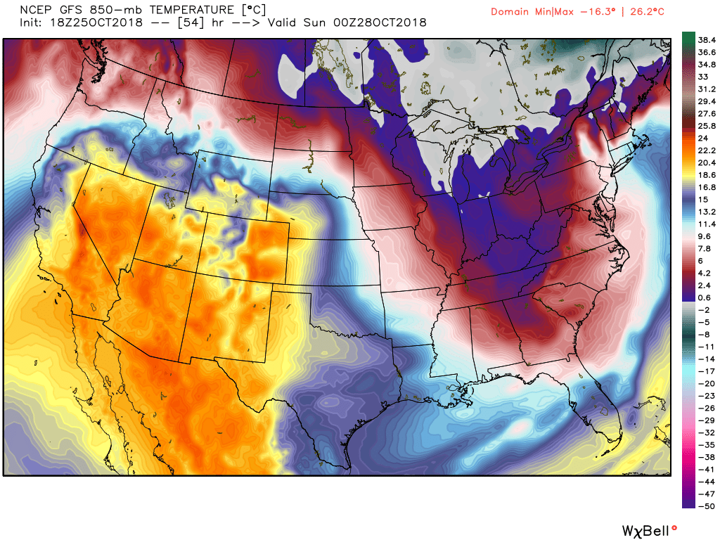
Below: Moisture is spreading into the Cascades with cooler temps on Sunday pushing into Idaho late in the day.
Image: Meteostar


BC will also see snowfall especially late in the weekend. My confidence is low on amounts for Interior BC due to fairly warm temps. Its possible the summit of Revelstoke and areas near Banff all pick up some freshies Sunday/Monday. Whistler will see decent amounts at the summit Sunday. Cooler air will be moving into the northern Rockies early next week dropping south into Colorado and New Mexico by mid week. Several period of light snowfall are likely in the extended forecast below for most of the Rocky Mountain forecast zones. Halloween will likely see light snow near Denver! Moderate snow is likely for much of the Rockies late next week as winds shift to the NW.
Extended Forecast
Cold air pushing down into the Rockies will kick off snow showers for the northern Panhandle of Idaho on Sunday night (Schweitzer) before settling into central Idaho on Monday. Areas in the southern Panhandle extending to Brundage (North Central Idaho) should see steady light snow Sunday night or Monday. Amounts will be highlighted in a later forecast. I am a bit more bullish for Brundage than the mountains of northern Idaho. Schweitzer is on the wildcard list especially at the summit. The Tetons will also get into the action by Monday morning with snowfall at mid and upper elevations. Amounts will most likely not exceed 2-4 inches.Light snow showers will most likely continue in the Tetons through Wednesday with some warming noted on Tuesday. Snow showers will continue at times late next week. Both Targhee and JHMR will be reporting higher totals late next week as winds shift to the Northwest and usher in a better chance of snowfall. This may also impact areas near Big Sky (Late next week) who appear to be in range of some moderate snow on Thursday.
Below: Cooler air impacting most of the PNW late Sunday and extending into the northern Rockies. Utah and Colorado remain on the warm side initially.
Snow will eventually get into Colorado mid next week. Models this far out are not providing me enough to forecast amounts. It appears that with North or NE wind direction the front range resorts closest to Denver will be favored. Amounts mid next week are not impressive on the Euro, and a bit more bullish on the GFS. Most of the energy may drop south of Denver. Peak snowfall will be late Tuesday night into Wednesday just in time for Halloween (BOO). Some snow will also be falling at upper elevations of northern New Mexico (Taos).
Additional snow is possible for much of Colorado late next week but I will address that in a later forecast (This is likely to bring snow to the I-70 corridor). The Wasatch sits just south of the heaviest moisture next week. NW flow and colder temps may offer some decent orographics to some areas of northern Utah. It's possible that 5-7 inches fall in the Wasatch especially on Thursday. This will be addressed on a later post as models gain confidence.
Below: Total snowfall for the west in the 7 day forecast (This will definitely change this far out in the model runs). Wide area of snowfall from the Cascades into the Rockies. Most of the Rockies are highlighted for late next week. The Cascades see most of there snow late this weekend.
Powderchaser Steve


