Summary NOVEMBER 2, 2018 7AM
I dreamed last night that I was at Loveland Ski area surrounded by powder without my snow tires, no gear, and stuck in the lodge. It was a nightmare to say the least. I woke up this morning looking at the models. You are in for a great start to November, especially if you live in the Tetons, or most areas of north/central Colorado. The Wasatch of Utah finally gets in the spotlight for Sunday night. Montana also is in the spotlight, however snow amounts might fall shy of the Teton chase. This is all good news so keep reading the Forecast. I am stoked to say the least!
Short Term Forecast
FRIDAY-SATURDAY: Moderate snow will be falling over much of north/central Colorado late Friday/Saturday. Models favor northern areas from Steamboat to Vail (5-9 inches). Nearly every ski area along I-70 including Aspen will have fresh powder for Saturday morning. You can chase to A-Basin and Loveland Saturday morning and hope for some freshies on the groomed runs. Get out this weekend and enjoy some of the new snow. I have been snowshoeing on every occasion possible where others are out Cross Country Skiing. Let the chase begin! What a nice change from the start of last season huh?
The Wasatch in Utah including Powder, Snowbasin, Solitude, Park City, Alta will see a quick shot of 2-7 inches on Friday night. This is a quick moving system with good favored wind direction especially for the Cottonwoods (LLC favored slightly). Additional snow will be falling later this weekend for Utah.
The Tetons will grab additional snow primarily Friday though late evening (3-7). Targhee and Jackson will both be reporting new snow by late Friday. Targhee may see some higher amounts benefiting from NW flow. This is a tease compared to the main event due on Sunday.
Significant snowfall is likely in the extended forecast so keep reading!
Below: Total snowfall for the west through Monday night.

Extended Forecast
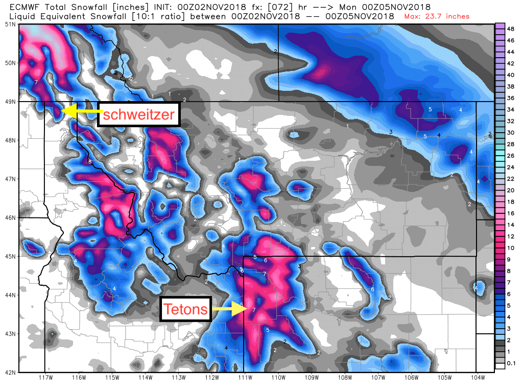
Snow will return to the northern Rockies late this weekend. Moderate snow will be likely at Schweitzer Mountain in Idaho late Saturday into Sunday morning, extending into central Montana thereafter. Montana Snowbowl may see some freshies at higher elevations by Sunday morning.
Heavy snow will be falling above 7,000 feet Sunday in northern Wyoming, extending into southern Montana Sunday. Amounts will be heaviest in the Teton Range. Significant snow is going to be likely from Targhee to Jackson, Teton Pass extending into southern Montana. My early guess is 9-15 inches at upper elevations in Wyoming and 5-10 inches in either Big Sky or Bridger Bowl. These amounts will be updated on a later post.
After chasing to Wyoming or Montana Sunday (No open resorts), you can drop into Colorado or the Wasatch Monday morning. Heavy snowfall is likely in most resorts of north/central areas of Colorado Sunday night. The northernmost. including Steamboat, Vail, Aspen, Snowmass, Beaver Creek, and most of Summit, Grand, Clear Creek County are favored. The models show decent amounts extending south into Crested Butte, Telluride, and perhaps Silverton. Winds seem to shift from NW to West which could crank some good totals for the Butte and Irwin Lodge.
Utah finally gets into the spotlight! Sunday/Monday and should deliver a solid event of moderate or heavy snowfall. The Cottonwoods should score 7-10 inches or more. The areas around Park City will see high elevation moderate snowfall that extends into the northern Wasatch (Snowbasin, Powder). Powder may be slightly favored up north with the wind direction (NW).
Below: Snow totals through Monday for Montana/ID/Wyoming (Courtesy of WX Bell)

special thanks to Mountain Wave Snowboards in Breckenridge for helping me out with my backcountry gear last week!
Powderchaser Steve


