
A moist system moving over the Cascades and British Columbia today will move into the Tetons after midnight Saturday. Light snow ahead of the front will be falling over the Tetons today (Saturday) with 1-3 inches possible by 5PM.
Moderate snowfall very early Sunday will turn heavier throughout the day. expect storm totals in the 9-14 inch range with some higher amounts likley at the summits through Sunday night. The majority of snow will fall during the day Sunday.
Very cold temperatures today in the single digits will rise tonight with the approaching front. Dry density snowfall will crank out significant amounts through the close of the lifts on Sunday. Snow may start out slightly denser (medium-light) and turn drier as the day moves on (Blower). Strong winds will peak in the early morning with gusts in the 35-45 MPH range. Temps at 9,000 feet will start in the 15-18F range and rise during the morning. Snow ratios (Liquid water to snow) will be high in the 15:1 inch range with most of the storm. Current models show 3/4 of an inch of liquid moisture through late Sunday. That could correlate with 12-16 inches of snow at the summits. Our best conservative forecast is for 9-14 inches by the time the lifts close on Sunday (These amounts include the light snow that falls Saturday). Your wake up call at 7AM might show 2-5 inches, where your 1st tram or chairs is at 4-6 inches. Late day will see some free refills as instability increases with the colder air moving in with wind shift to the NW.
Winds will be west tonight initially but switch to the NW late AM Sunday. The Tetons do well with both wind directions giving a slight favortism to JHMR initially and Targhee on the shift to the NW. Teton Pass will have reduced visability due to light density snow, strong winds and whiteout conditions. Winds decrease somewhat Sunday afternoon. Avalanche danger will be rising!
Very cold air will push in Sunday night/Monday. This will keep some snow showers going through the evening hours. Winds will diminish late Sunday.
Currently, the snowpack in the Tetons is between 80-90% of normal (varies by location). This storm, with cold temperatures will increase those numbers by Monday. Areas of the Tetons that have seen lower snowfall totals at the bases will bump up nicely after this storm. These numbers will likley bump to near normal by Monday morning especially the summits.
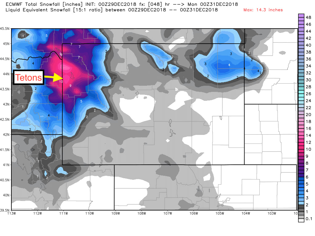
Below: Total snowfall through late Sunday night (Includes the light snow from Sunday). Image: WX Bell

Below: Total Moisture for the Tetons may approach an inch of water through Sunday evening (12-18 inches of snow). The Euro models are slightly less bullish. Image: WX Bell

Below: 9800 foot elevation temps Saturday (4 degrees F this morning at 0800).

Below: Rising Temps Satiurday night into Sunday morning (12-18F at 9800 feet).

Below: Temps turning colder Sunday PM to Monday AM with light snow showers continuing.

Courtesy of Powderchasers.com.


