
After a fairly dry and quiet last week, things are looking promising heading into Christmas and New Years. Several major systems will bring significant snow to the West Coast, promising a deep start to 2023.
The first system is already in motion and has already dropped 1-2 feet of fresh snow on Washington state. At the time of writing this article, most of the precipitation in the PNW is wrapped up, with only a few more inches on the way for resorts south of Stevens Pass. Today Powderchasers hit the backside of Stevens on the first public chair.
Announcement!
Powderchasers and our forecast staff is supported by our readership, so if you have not donated, please do so here or join our powder concierge program where we provide 1:1 trip planning for chasing, last-minute custom forecasts, and the best pow day of your life. Support our sponsors and be sure to follow our Instagram and Facebook page @powderchasers.
Below: You can see only light snow showers remaining for Washington Tuesday night with some isolated pockets noted in northern Oregon.

The highest snowfall for late Tuesday through Wednesday will be found in the western panhandle of Idaho (Ski Lookout or Silver) extending into the Tetons. Winds will be strong with gusts in the 60's through early Wednesday so expect some lift delays or closures in the Tetons initially. We expect 4-8 inches for the Tetons Tuesday night and another 3-7 during the morning hours of Wednesday. The summits of the Teton ranges will be peaking out around 12-14 inches. JHMR is favored over Targhee in this pattern. Teton Pass should also do well. Caveat: Strong winds initially through Wednesday morning, windblown pockets, increasing avalanche danger, some delays in opening are possible.
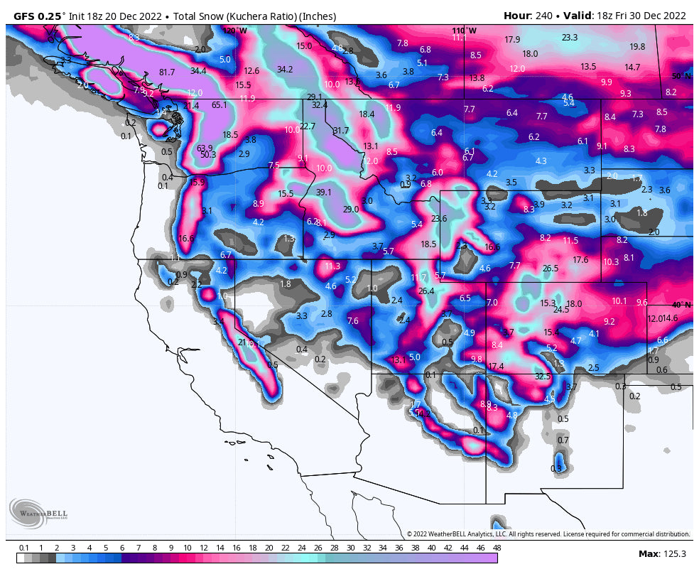
Below: Totals precipitation for the Rockies through Thursday morning (Highest amounts for the Tetons, Northern Wasatch, Northern Colorado. Ride Wednesday or Thursday with Wyoming primed for Wednesday morning.

Precipitation will begin in Utah and Colorado tonight ahead of a major polar air outbreak for the midwest. The first wave of this precipitation will be fairly minor; by the time lifts start spinning on Wednesday, resorts in Colorado and Utah will only be looking at trace-3” of snow. Resorts in Little Cottonwood Canyon may end up on the upper end of that range or perhaps even 4-5”. Fingers crossed, but keep expectations low, especially for Colorado resorts.
Throughout the day on Wednesday, light to moderate precipitation will linger for Utah with very strong winds. Expect some upper mountain delays or closures (Stick to lower elevation resorts). The northern Wasatch near Ogden or as far north of Logan might see higher amounts initially on Wednesday. Wasatch resorts will pick up an additional 3-5” by the time the lifts stop spinning on Wednesday (7-11 totals). Northern Colorado will see much heavier precipitation rates as a piece of storm energy causes some intense snow bands to move through. By the time the lifts stop spinning on Wednesday, Steamboat should be at 7-10” with totals closer to 2-4” for the I-70 and central mountains and virtually none in the southern mountains.
Overnight on Wednesday, the embedded bands of heavier snowfall will creep further south, setting up over I-70 and the central mountains and bringing the potential for forecast-busting totals. By Thursday morning, Steamboat will have picked up an additional 5-8”, bringing the total to 12-18”. I-70 resorts should pick up 4-7” total, and central mountains like Aspen and Crested Butte should see 3-5” with an extra inch on Thursday night. The chase target for Colorado during this storm is 100% Steamboat, as it often does very well with this northwest wind direction and could out-perform the forecast. Also look for areas near Vail Pass that often do well with NW flow.
Temperatures in Utah and Colorado will be excellent for this storm and the snow quality will be great.

NBM snowfall through Saturday morning.
Overnight on Thursday, the next storm moves into the Pacific Northwest. Unfortunately, this storm is much warmer than the last one and will bring mixed precipitation to even the upper elevations of local resorts. Friday may start off cold and snowy, but it will quickly turn to rain and sleet by the afternoon. Conditions could actually be pretty good in the northern and central Cascades on Friday morning, with 8-14” from the night before. However, that will be washed out by rain and mixed precipitation throughout the day. The models are keeping things a bit colder up by Mt. Baker, which I think could stay all snow on Friday; this could be a great chase target for Friday with the new snow from the night before and colder temperatures on Friday. Check out the chaotic precipitation-type chart from the Canadian model for Friday afternoon. Not a great afternoon to be skiing at most ski areas around the state. In the map below, blue shades indicate snow, yellow indicates sleet (rain/snow mix), pink indicates freezing rain, and green indicates rain. In other words, if it's not blue, its bad for the snow:

An even stronger wave of warm moisture hits the Cascades on Saturday, bringing even warmer, wetter, conditions to the region. Even Baker will see rain and mixed precipitation during the day on Saturday. Once again, notice the intense shades of green, yellow, and pink, indicating bad precipitation for the snow:

For most resorts, Saturday will be another day of dismal ski conditions, with extremely heavy, wet snow at the highest elevations and rain/mixed precipitation down low.
However, the tail end of this system could bring big snow to the northern Cascades; look for Sunday to be a sleeper powder day, with higher totals the further north you go (Baker chase!).
Beyond this, we don’t have a great idea of specifics, but I’ll give you a brief look at what the pattern is looking at following Christmas and heading into New Years (spoiler, it looks good).
The next system moves into the PNW overnight on Monday (12/26). Monday and Tuesday look like more messy days with warm temperatures and mixed precipitation at resorts. However, once the main storm hits on Wednesday, snow levels will drop and snow quality will improve considerably.
A strong plume of Pacific moisture will push south into California on Tuesday morning, bringing low elevation rain and high elevation snow. The American and European models keep this first wave colder while the Canadian brings warmer, mixed precipitation. All models have another wave moving through on either Wednesday afternoon or Thursday morning. The second wave does look smaller than the first, but the colder environment primed by the first wave will mean lower snow levels and higher quality snow! California is shaping up to be an excellent chase target for late next week, stay tuned as the storm gets closer!

Most storms that move through California also do well in Utah and southern/central Colorado. Look out late-week powder in those regions, as well. Specifics TBD but it’s looking promising!
Happy chasing!


