Our main focus this week will be on California, Utah, and Colorado from Monday morning through Wednesday night.
Palisades Tahoe has seen 5.8" of liquid in the last 5 days, almost 30" of snow. Mt Rose saw 2.9" and 10-15" of snow. Heavenly saw 12". Mammoth saw 18". Much more snow is about to slam into the Sierra.
NOTE: Please support Powderchasers with a donation, Merchandise purchase such as a hat or stickers, or sign up for our custom Concierge Powder Forecast Package where we provide 1:1 phone and email support to get you to the deepest locations possible. Outside Magazine listed Powderchasers in the top 3 sites with the custom concierge program. These ways to support us will allow us to keep you chasing the deepest snow all winter! It's time to start trip planning and chasing pow!
California

California will see snowfall from Monday morning through Tuesday night. Most of the snowfall will fall in the southern Sierra, with a bullseye likely just north of Mt Whitney. However, resorts will still see healthy snowfall with this one.
Snow levels will spike to above 7,500 feet at the start of the storm, peaking on Monday afternoon/evening. This will bring good base building snowfall to many areas with the highest totals from Kirkwood to Mammoth (Southern influence).
Here are totals at mid-mountain elevations by Tuesday night. Keep in mind these totals will be very elevation-dependent due to the finicky temperatures.
- Palisades Tahoe/Sugar Bowl: 9-15"
- Kirkwood: 12-20"
- Mt Rose: 4-10"
- Heavenly: 7-13"
- Mammoth: 26-38"
Utah

The same moisture that's hitting California will also impact Utah from Monday evening/night into Wednesday morning. Snow levels will initially rise with the warm AR decaying moisture tap from the Sierra. This could rise levels as high as 9,000 feet in the southern Utah Mountains and 7,000 feet in northern Utah. The moisture tap is going to favor the southern and central mountains initially under SW flow.
Areas that can do well in this pattern are all of the southern zones (Eagle Point, Brian Head) and extend north to Provo Canyon (Sundance). Slightly lower totals might be found further north along I-80 or north initially.
Colder air moves in under NW flow later Tuesday night or Wednesday and brings lower density snowfall to most of Utah that will favor the Cottonwoods and all mountain ranges along I-80 (PCMR) and north.
Cottonwood resorts will likely pick up 15-25", with PC & DV seeing 10-18". Areas north in the Ogden or Logan area should grab 9-16 inches.
Below: University of Utah ensembles showing averages at the summit of Park City Resort in the 15 inch range through Wednesday (Averages are the darker blue and red lines) Some members show 10 with others as high as 20 (Mean 15).
 '
'
Below: With decent moisture in southern Utah ensembles show even higher amounts possible for Eagle Point through Wednesday.

Colorado
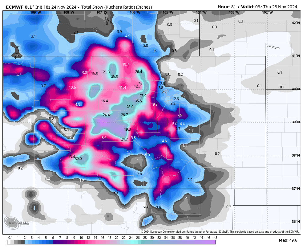
Colorado is third in line for this storm and will get absolutely dumped on! Snowfall will begin filling in early Tuesday morning and will persist into Wednesday afternoon/evening.
Mid-mountain totals will be as follows:
- Steamboat: 18-30"
- Winter Park: 15-24"
- Arapahoe Basin/Loveland: 20-32"
- Breckenridge/Copper: 14-22"
- Vail/Beaver Creek: 16-25"
- Aspen/Snowmass: 18-28" (potentially 30"+ at Snowmass)
Below is the ECMWF forecast by Wednesday night. These numbers are likely major under-forecasted; this output assumes 10:1 snow ratios:

Looking ahead
Looking ahead, it looks like things will quiet down for some time. We might see a few showers north of the Canadian border late this week, stay tuned for a forecast if that materializes. However, after Wednesday, the end of November and at least first week of December will be mostly quiet for most of the west.
Our friends at skis.com are kicking off a pre Black Friday sale with up to 70% off on apparel, outerwear, and Ski accessories. Please check out this sale here (https://skis.com/). All sales over $200 earns you free Powderchasers shirt as well (email us!).


