Summary:
Cold air will bring Halloween Treats this weekend to the Sierra Range, pushing snow levels near Lake Level by Sunday. Widespread 9-17 inches are likely, favoring the southern Sierra Range above 8K. Some light snow is possible at lake level. Warm S-SW flow exists for the southern Rockies with 10K snow levels on Sunday. Cooler air and NW flow bring phase 2 of the storm from Sunday night to Monday.
The southern San Juan Range of Colorado could nab 15-20 inches or more above 10K.
Phase 2 of the storm (Colder) might sneak out some deepish surprises for northern Utah, especially the Cottonwoods. Moderate totals are possible for the I-70 corridor of Colorado, the Tetons, and perhaps central Idaho.
Overall, this will be a good storm to build bases, especially in the southern or central Sierra and southern Colorado. The Wasatch Range is likely to overperform with NW flow Sunday night/Monday. Central Idaho is a wildcard, especially at upper elevations north of Sun Valley near Galena Summit.
Below: White Pass in the southern Cascades of Washington nabbed nearly 14 inches of powder! Areas north picked up 6-10 inches.

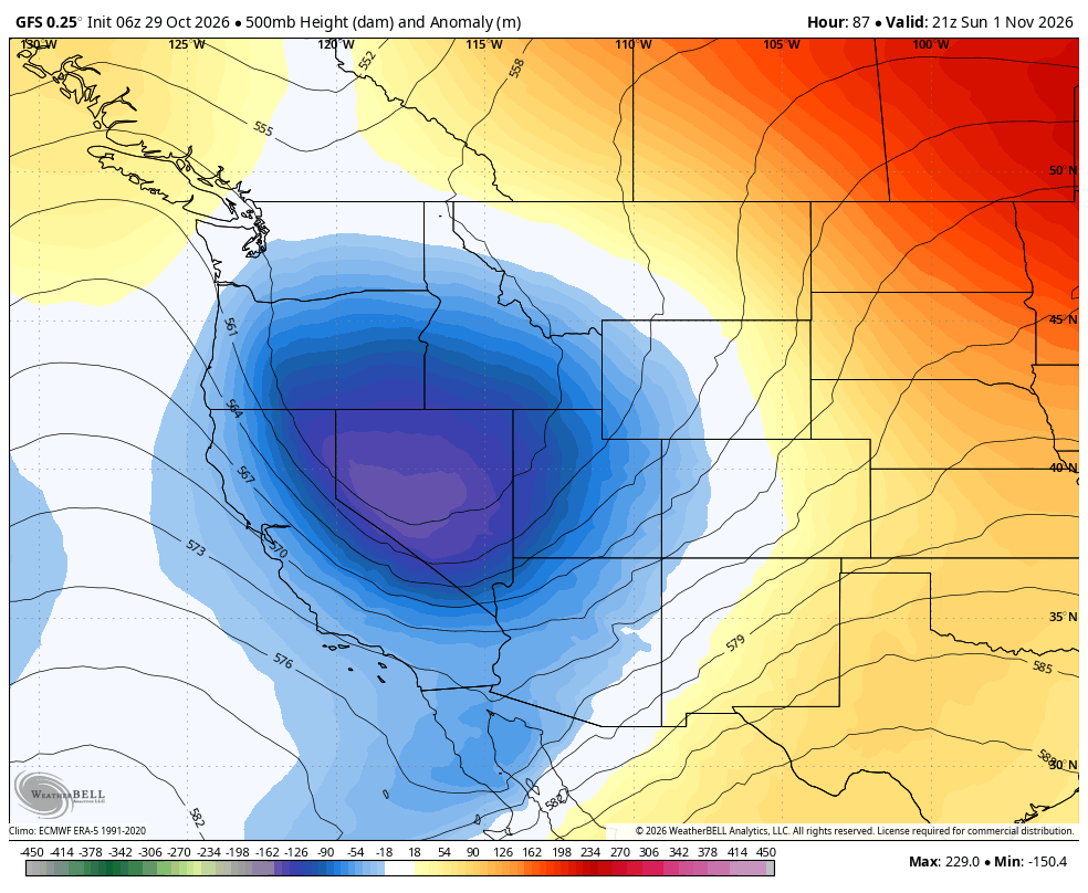
Below: Low pressure aims from the Sierra into the southern Rockies beginning Saturday and exits the region by Tuesday.

Below: Total Precipitation through Monday afternoon (Near 2 inches in the Sierra and the San Juan Range in Colorado. The Uinta Range in Utah peaks on this map, followed by near 1.5 inches for the Wasatch. This storm starts out very warm, so snow totals will vary considerably by elevation.

Below: The American GFS is the most bullish, with decent Sierra totals (I favor the southern regions of the lake or south to Mammoth), the Uinta Range of Utah (High snow levels), and high confidence in southern Colorado (20 inches at upper elevations above 10K). The map is through Monday night.
Central Idaho will grab light to moderate totals (Galena Summit), as will the Tetons (3-7). AZ might sneak out some moderate snow totals at the peaks. The peaks of the Uinta Range (SE of Park City) will see signficant totals at the upper elevations (PC Cats operates in the Uinta Range).

Below: Cold air GIF from Saturday to Monday. Cold air hovers in the Sierra (6-7K snow levels) with this storm, while warmer air is noted in Utah and Colorado (10K snow levels) this weekend.
The colder air hits the Wasatch Sunday night and Colorado on Monday. The Cottonwoods will tick up on snow totals during this period (7-15). I-70 will sneak out some moderate totals Monday.

Below: University of Utah plumes based solely on the GFS model show a transition at Alta from Sunday evening to Monday (7-15 inches likely). This is reasonable.

Bottom Line: Moist storm with up to 2 or more inches of liquid. Cold temps in the Sierra will bring decent totals above 7-8K. Warmer in Colorado with signficant moisture aimed at the southern San Juan Range (10K snow levels). Colder air and NW flow with phase 2 of the storm in Utah/Colorado favor the Wasatch and push light to moderate totals into the I-70 corridor of Colorado. The southern San Juan Range sees lighter totals during this phase. Tetons and central Idaho see light to moderate totals.
Sponsor Alert: Tire Rack has some powderchasers winter tire promotions at the link here

Forecaster: @powderchasersteve (Instagram)
Please help us out if you read our free forecasts by considering some of our high-quality merch in our powderchaser store. The Concierge program gets you to the deepest powder with every storm!
HELP US OUT- Please support your love of powder and our free forecasts with a donation here