
We just came off a 95 inch chase from Utah to the PNW, Tetons, Aspen, and back to the Tetons (17 inches from Tuesday to Wednesday).
The next 7 days will offer many options for chasing powder.
Colorado- Thursday to Friday storm
This is a tricky forecast with only moderate confidence on who if anyone grabs deep snow. An unorganized storm with upslope flow seems to favor the Front Range Foothills a bit more than the Ski Areas near the Divide.
Winter Park, Eldora, and AB, and Loveland all would be favored in this pattern, however moisture seems sparse. We are keeping expectations low and only going with 0-5 inches. Well that's odd, seeing a skunk number in here but confidence is low. Temps are also noticeable colder as you travel east towards the urban corridor versus the mountain corridor.
The good news is that the short term high resolution models are hinting at some convective snow bands to set up somewhere between Summit and Eagle Counties Friday mid morning or afternoon. This might kick off higher totals than the Front Range resorts by late Friday. Temps are cooling Friday as the cold front advances into the western corridor. Snow showers could be heavy at times Friday early PM to late afternoon. This might provide a crowd free last chair somewhere west of the Divide on the I-70 corridor Friday. Saturday could even offer some additional powder.
The tricks of a Colorado forecast also note that N, or NW flow is noted in the northern San Juan ranges. The models have been consistent in some moderate or even higher totals for Red Mountain Pass and Telluride. Areas north of Pagosa are also looking decent (Outside of the Ski areas to the south). We have a bit more confidence in the northern San Juan Range versus Wolf Creek in the southern San Juans (SW flow is more ideal for the Wolf and Purgatory).
Below: Upslope wind direction noted for the Front range (Light winds are not great for orographic lift towards the Divide). NW winds noted for the northern San Juan could land some surprise totals there. N and NE winds noted in the southern San Juan range might push higher totals just north of Pagosa Springs. Wolf Creek is a wildcard.

Below: Below: Cold air is confined to the Urban Corridor Friday morning extending to the Passes (WP, Eldora, Loveland).

Below: Cold air advances west over the I-70 corridor late Friday-Saturday. This might kick off some convective snow showers that could add up in a short period of time for the western corridor from Summit to Eagle County. Aspen is a wildcard.

British Columbia and PNW
The highest snow totals will be in western BC where heavy snowfall is likely Friday/Saturday, trending more moderate Sunday/Monday. Snow levels will be near or just above the base areas (Dense at lower or mid elevations). Winds will be light which will improve the odds of upper lifts spinning and increasing quality. We expect snowfall totals to be in the 2-4 feet range by Monday.
Moisture pushes south into the Cascades Saturday AM favoring the northern resorts (Mt Baker) with SW winds (good wind direction for the northern Cascades). While no single 12 hour period looks deep for the Cascades the sum totals will range from 12-25 inches by Monday afternoon.
Mt Baker grabs a storm ski day Saturday and a low to moderate overnight dump for Sunday. Ski areas south extending into Oregon will eventually ramp up Saturday night to Tuesday with several rounds of 3-7 inches (Every 24 hours).
Below: Snow totals through Tuesday March 13. They are very plentiful for western BC (Coastal resorts also) with less as you travel south. Washington and Oregon resorts will still grab and excess of 12-18 inches but spread out over several days from Saturday to Tuesday. BC might peak Friday-Sunday.

Sierra
The Sierra grabs good timing with Sunday afternoon snow increasing in the evening and ending Monday morning. (5-10). Another burst of light or moderate snow if possible Monday night to Tuesday (3-7).
Below: Total snowfall for storm #1 in the Sierra peaking Sunday afternoon to late PM. Snow levels start at 6K and lower through the storm. Not a huge storm (Certainly tiny compared to recent ones) but enough to freshen things up with right side up snow (Warm to cold). Areas near the southern end of the lake or Mammoth could be deeper. Eastern sides of the lake will see less snow.

Extended:
Looking out into next week moisture from the Pacific Storm Monday spreads east over the Rockies. Utah and Colorado might benefit the most with some decent totals starting to show up on the models for Tuesday or Wednesday. While this is not a huge system it might land double digits for some ski areas.
Below:n 48-hour snowfall ending Thursday, March 14th on the European Model (Has been a pessimistic model recently) showing some decent totals in Utah and areas of Colorado mid-next week. Areas north of the Tetons will likely see less. It's too far out for accuracy, but confidence is decent of a fast-moving wave by Tuesday night to land 12-plus inches to some locations.

Below: The mid next week storm seems to take a southerly track into the 4 corners.

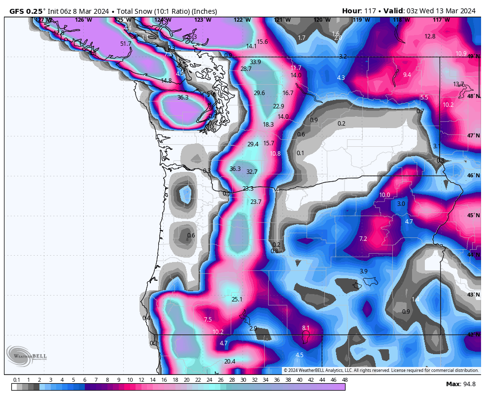
Below: Total western snowfall at 10:1 from March 7 to March 14th. Most of the Rockies are scoring mid-next week with the Sierra on Monday. The PNW and Canada score in the short-term ranges this weekend and early next week.

HELP US OUT! Please donate here to Powderchasers if you have taken advantage of our free forecasts. This Is our number one source of revenue. Free swag for you on all donations from $50 and up. $100 donations grab you a custom shirt also!
We have new Powderchasers shirts fresh off production for sale currently for just $32 (Front and back powder)


Don't forget if you want to chase powder to the best locations every time, join our concierge package here. This provides custom 1:1 consults.
Powderchaser Steve (@powderchasersteve)


