A storm is departing Colorado on Friday night and performed pretty much as we expected. We were never that optimistic for deep Divide totals with our previous forecast at 0-5 inches (Most resorts reported 1-4). With a tricky Colorado Forecast it actually panned out (Eldora had 7). In fact, the convective snow bands we talked about for Summit or Eagle County Friday afternoon did occur with Breckenridge grabbing a quick 6 inches after 11AM. We got lucky with our forecast and the models did a good job for us.
Support our sponsors!
Up to 65% off blowout sale for Skis.com, 15% off your entire order from our newest sponsor Purl Wax, when using coupon code POWCHASERS at checkout. They make fluoro free ski/snowboard wax that is hand poured in Colorado! Finally, coupon code POWDERCHASERS gives you free activation on your Zoleo satellite communicator! We highly recommend carrying a satellite communicator of some kind when traveling in the backcountry!
Below: Convective bands set up over Summit County Friday late AM to early PM as we had forecasted and provided a nice refresh for Breckenridge. Special thanks to Eric from previous Mountain Nomads for alerting us.

Below: Snow has dropped south over the southern San Juan Range with Wolf Creek Pass scoring snow showers Friday afternoon providing a light refresh possible for Saturday. We don't expect big totals.

The big winners this weekend will be coastal BC from the northern areas near Bella Coola, Shames and extending to Whistler and Cypress.
Strong winds and moderate snow Friday night turns heavier on Saturday with slowly rising snow levels (2900 to 3K). Snow totals along the coastal areas might range from 1-2 feet. Whistler will see less with 10-18 inches by midday Saturday. Expect upper lift impacts on Saturday. Snow mixed with rain at the base will change to all snow by later in the weekend.
Below: Strong winds from the S, SW are aimed at coastal BC extending into Whistler this weekend. The winds will decrease on Sunday by mid morning (Might pop the summits). Winds could put a damper on a long term chase on Saturday for BC as many lifts will not be spinning (Maybe Cypress is the right call but with snow levels at 3K it might be dicy).

Heavy snowfall Saturday will decrease late only to be replaced by 2 additional fronts that should keep light to moderate snow falling thorough the weekend, perhaps into Monday. Snow levels will lower increasing quality by Sunday/Monday. Amounts won't be as heavy as Saturday but respectable for some great skiing into early next week (less wind, colder and still snowing).
The Cascades get the leftovers with Mt Baker favored with SW flow. The entire Cascade Range from Washington to Oregon grab steady light to moderate snowfall through Tuesday. These totals will add up slowly (No big single epic dump) with 12-20 inches at many resorts (Northern areas favored). Monday night offers the final wave that might do better for the central and southern Cascades, overnight totals, and better quality. Northern Idaho will also do well with this storm (Selkirk Powder Guides).
meanwhile as the PNW gets pounded this weekend, the Sierra offers 2 storms. Both are in the 3-7 inch range for both Monday and Tuesday.
Below: Storm #1 for the Sierra due Sunday night could land 3-9 inches for the Sierra Crest favoring resorts on the northern end of the lake (West towards Donner Summit).

Below: Storm #2 due Monday night looks to spread an even 5-10 inches to many resorts in the Sierra. Both storms are not big especially by Sierra standards, but have great overnight timing!

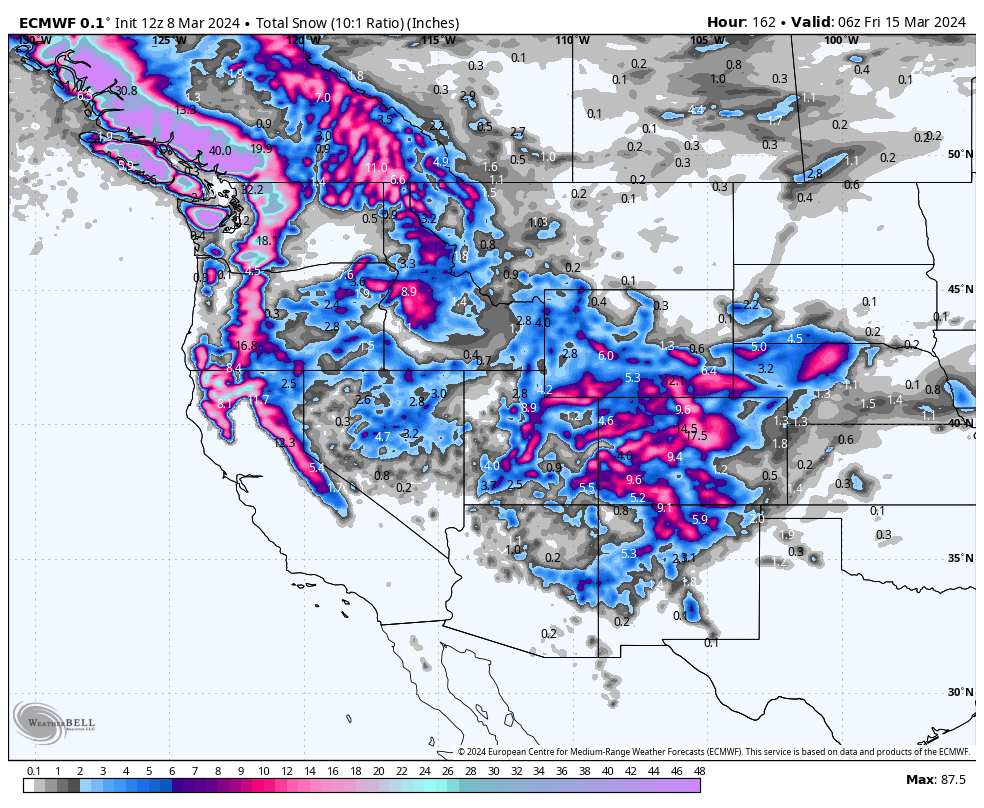
Low pressure skirts east over the Rockies by Tuesday or Wednesday next week. Currently the low appears to stall and cutoff somewhere in the 4 corners. Higher totals might land in the Wasatch, southern Utah (Brian Head, Eagle Point), Northern Arizona (AZB) and a good portion of Colorado next week.
Below: Low pressure tracks over the Rockies midweek and appears to cut off and stall over the 4 corners by later next week. This could provide some big totals for the 4 corners by mid to late next week.

Below: 7 day total snowfall with the PNW and coastal BC in the highest ranges (Short term), Moderate ranges for Interior BC, respectable 2 day Sierra totals (10-14). Northern Idaho near Selkirk, Powder Guides, western Idaho (Brundage), Tetons (Lighter totals), and most of central and southern Utah. Colorado and New Mexico could do very well with this storm (Arizona wildcard). 7 days out can see many changes but confidence is pretty high of a story period mid to late next week for the Rockies.

HELP US OUT! Please donate here to Powderchasers if you have taken advantage of our free forecasts. This Is our number one source of revenue. Free swag for you on all donations from $50 and up. $100 donations grab you a custom shirt also!
We have new Powderchasers shirts fresh off production for sale currently for just $32 (Front and back powder)


Don't forget if you want to chase powder to the best locations every time, join our concierge package here. This provides custom 1:1 consults. You won't miss the deep.
Powderchaser Steve (@powderchasersteve)


