
The weekend chase belongs to the Sierra. Snow starts wet and wind-affected Friday, but the storm deepens through Sunday while snow levels tumble below the passes, and Kirkwood is the standout for both volume and improving quality. Mammoth and Palisades Tahoe are right behind, especially once the colder air arrives late Saturday into Sunday.
After that, the focus shifts north. Utah gets a smaller Sunday night into Monday refresh, then a colder Tuesday night through Thursday cycle spreads into the Washington Cascades, Idaho and Wyoming, and the Canadian Rockies. Confidence is best from Friday afternoon through Thursday night: the Sierra storm has the tightest agreement, while the midweek northern wave is solid on timing but still a little looser on exactly where the deepest snow sets up.
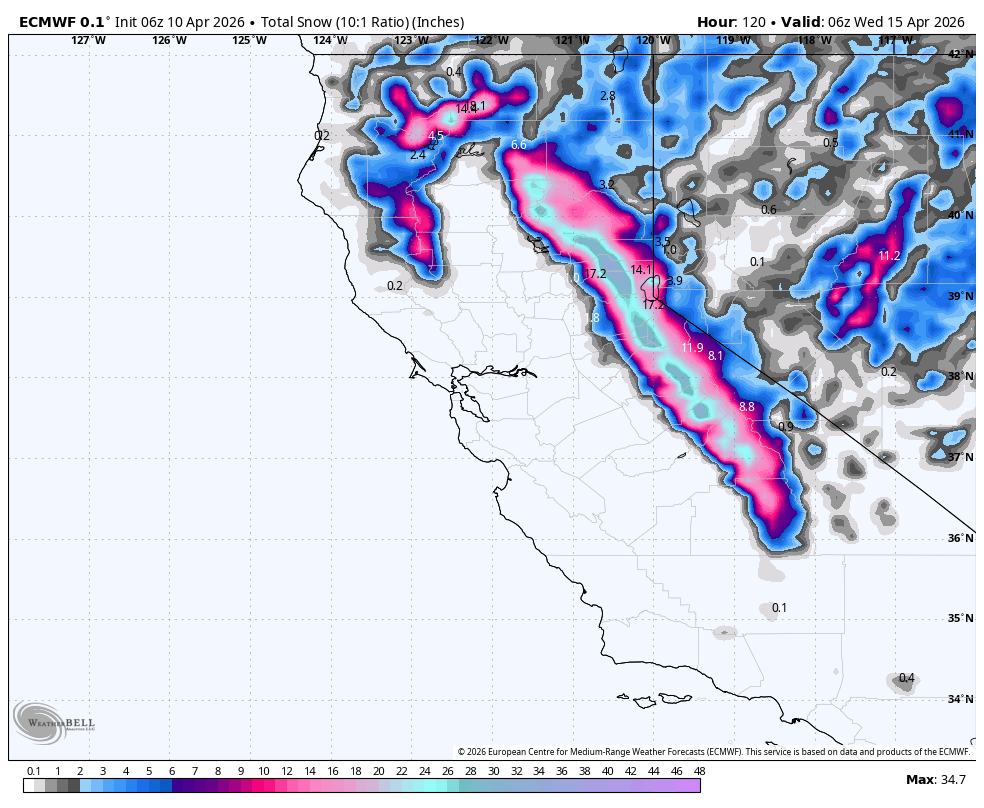
Top Resort Snowfall 6 Totals (April 10-April 16)
These numbers combine 2 storms in the next 7 days.
- Crystal Mountain: 7-13 inches
- Snoqualmie Pass: 8-14 inches
- Stevens Pass: 9-16 inches
- Brundage: 9-16 inches
- Grand Targhee: 9-16 inches
- Alta/Snowbird: 5-12 inches
- Timberline: 10-18 inches
- Mt. Baker: 10-18 inches
- Palisades Tahoe: 14-20 inches
- Mammoth: 14-20 inches
- Kirkwood: 22-28 inches
Storm Timing and Discussion
Storm #1
A strong Sierra cycle is underway from Friday afternoon through late Sunday night. Guidance is tightly lined up on timing, snow levels, and the windy start, with snow levels beginning around 7000 to 8500 feet before dropping below most passes by late Saturday. The main divergence is on exact intensity and placement of the heaviest snow, with the south Tahoe to Kirkwood zone holding the steadiest signal while Mammoth and Palisades Tahoe wobble more from run to run. Kirkwood could stack 21-28 inches by Monday morning, Mammoth 13-19 inches, and Palisades Tahoe 13-24 inches, but expect a wet and wind-bothered start before the skiing gets lighter and better late in the storm. The higher end totals will be above 8K especially early in the storm cycle.
The storm weakens heading into Utah, so the Wasatch looks like a refresh instead of a reset. Solutions converge on snow returning Sunday night and on another round of strong ridge wind, but they diverge on how long the tail lasts into Tuesday and how much energy survives east into Colorado.
The Cottonwoods in Utah are still good for 5-11 inches through Tuesday morning. Peak snow comes Sunday night into Monday mid morning with SW flow (A bit denser but respectable 6500K Snow levels). NW flow and colder air Monday night might add a bit of cold fluff for Tuesday morning. Utah models have waffled with a boom or bust on these numbers (5 versus 10 or perhaps higher totals). It will be a 2 step process (Sunday/Monday and again Tuesday morning vs any single deep 12 hour event.
Colorado can sneak out some snow around the Front Range hills, but totals stay lighter and the bigger destination resorts that could have made noise are largely closed already, so it does not look like the best use of a chase.
Storm #2- Cold Air and Moisture Aim for Canada and the PNW.
The next meaningful shift comes Tuesday night through Thursday, when colder air spreads from the Cascades into Idaho, western Montana, Wyoming, and Alberta. Timing agreement is solid, snow levels are not a problem, and the wind forecast is a little cleaner than the snowfall placement forecast: Baker and Stevens stay relatively protected, while Timberline and some Rockies ridges look rougher. The bigger spread is on exactly where the deepest snow settles, with the best signal rotating between Washington, Idaho, and the Canadian Rockies, so confidence is a little lower on rank order than on the fact that the northern half of the map turns on. Mt. Baker could reach 10-18 inches by Thursday night with Stevens Pass at 8-15 inches, Banff Sunshine around 12-22 cm, and Grand Targhee 6-12 inches.
Daily Chase Recommendations
Each day's snowfall range combines the previous night (4 pm-8 am) and that day (8 am-4 pm).
Saturday

- Kirkwood and Palisades Tahoe are the best Saturday targets, with 4-7 inches of heavy snow and enough elevation to stay mostly white despite gusty ridges. Snow quality will improve during the day. Mammoth looks slightly warmer.
Sunday

- Sunday offers the deepest turns in the Sierra with 9-12 inches from Saturday night and high quality (Snow level 4500 feet). The lake Tahoe resorts might outscore Mammoth further south but it could be close.
- Some resorts in the Sierra will approach 2 foot or higher storm totals above 8K by Sunday morning.
Monday

- Kirkwood stays on top Monday with 6-9 inches of lighter snow on top of a deep weekend base, while winds back off enough for much better quality turns.
- Alta and Snowbird are the best Monday backup with 3-5 inches additional snow, but lingering ridge wind keeps them behind the Sierra. This is on top of the moderate totals from Sunday to Sunday night. .
Tuesday

- Alta and Brighton are the best Tuesday targets, with 3-5 inches of additional snow (Monday night with NW flow) cooler temperatures, and far less wind. Monday is the deeper day but models are still waffling between 3-10 inches (Monday).
Wednesday- Action with storm #2 swings into Canada/PNW.

- Mt. Baker and Stevens Pass are the top Wednesday chase, with 6-11 inches of creamier moderate snow, cold enough air for full-mountain coverage, and little wind damage.
- Whistler and most of the interior of BC and Alberta are scoring.
Thursday

- Banff Sunshine is the Thursday quality play with 6-12 cm of fluffy snow, very cold temperatures, and a fresh 3-day base.
- Grand Targhee is the Thursday volume backup with 4-9 inches of moderate to fairly light snow, though ridge wind will keep it less clean than Banff.
Announcement: Ikon Rates go up after April 16th, and if you plan to renew, you can do so with the lowest rates here

Extended Outlook
Beyond Thursday, the larger western pattern still favors cooler and periodically active weather from Washington and Idaho into western Montana and the Canadian Rockies, so those zones should keep seeing refresh chances. The Sierra should slow down after this weekend storm, though northern California can still catch a glancing follow-up, while Utah and Colorado look more hit-or-miss with milder breaks between weaker waves and no clear late-period winner yet.
Reminder: Ikon Pass Rates go up on April 16th, so if you plan on renewing, click here
WE NEED YOUR SUPPORT: Please support Powderchasers with a donation below or check out our Merchandise and Concierge packages (Custom chases 1:1). These support the free forecasts each season. We are


