
High-Level Discussion:
A warm and tranquil period this week will transition to unsettled and wetter conditions by the weekend. 2 Low pressure systems will merge over the Sierra by Saturday/Sunday and combine with a cold front lower snow levels to lake level by Sunday.
Initially, rain will be falling below 9K in the Sierra with the cooling trend due later Saturday to Sunday. Double-digit powder is likley with this storm at mid or upper elevations of the Sierra. Cold air on Sunday brings lake level snow.
The low tracks over the Rockies with SW flow migrating to NW Flow and colder temperatures for the central Rockies (Utah, Colorado). The northern Rockies will likley see lower totals. The low tracks from Utah early next week into Colorado, albeit weakening somewhat as it moves east.
We are still 5-7 days out from the action, so confidence in this forecast is still a bit uncertain.
Some expected snow totals through early next week.
Palisades: 12-18 inches (Above 8500), 4-6 at the base
Mammoth: 12-18 inches
Alta: 9-15 inches
Snowbird: 9-15 inches
Grand Targhee: 5-10 inches
Aspen: 4-9 inches
Winter Park: 3-7 inches
Announcement: Ikon Rates go up after April 16th, and if you plan to renew, you can do so with the lowest rates here

Saturday 4/11 to Tuesday 4/14
The European model shows one system moving into the southern PNW, with a 2nd weaker low aimed at the Sierra by this weekend. This weaker low is absorbed by the larger low to the north. The combined low aims for the heart of the central Rockies and stretches south to the San Juans. The period for the highest odds of snowfall occurs this weekend (Start of the loop) and extends into the Rockies by early to mid next week (Loop ends late Tuesday).

The European model shows a similar path for this weekend into early next week.

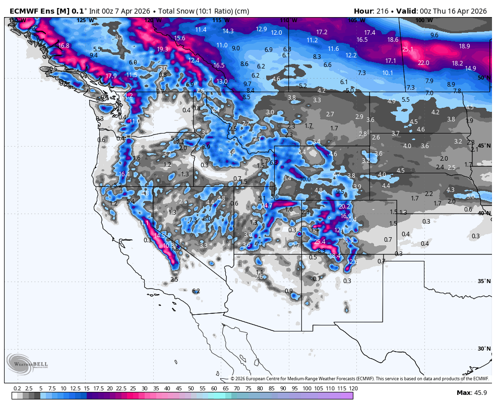
Below: European ensembles focus the heaviest odds of double digits in the Sierra, followed by Utah and perhaps southern and even central Colorado. We are still a bit outside the range of confidence.

Below: The American GFS ensembles are in agreement with the European above, perhaps a bit more optimistic in the Tetons.

Temperatures from Friday night (4/10 to Monday night (4/13)
Below: Temps in the Sierra keep snow levels (-2C to -4 at 10K) near 8500K early this weekend, but quickly transition to -10C at 10K, lowering snow levels to lake level by Sunday/Monday. This cold air shifts east over Utah by Monday.

Below: University of Utah ensembles show decent agreement of the ENS and GEFS ensembles (Red and blue lines are together) for Alta early next week (15-18). Many lines are below, and some above these averages, so confidence is a bit low right now. The Bonus: Storm starts with warmer SW flow and ends with cold NW flow, which is a good recipe for much of the Cottonwoods.
 Bottom Line Chases:
Our confidence is decent for the entire Sierra Range for resorts that are still open. Rain, mixed snow/rain, later this week into Saturday, provides good odds of 12-15 inches above 8500 feet by Sunday. Higher amounts might be found near the summits above 9500-10K. Utah seems to be in the best setup for early next week, with some wildcards for further north in the Tetons (Lighter totals). There is still a boom and bust scenario for Utah.
Colorado seems a tad warmer as the cold front weakens, but the low tracks directly overhead. Convection will determine the winners as mositure wanes a bit, and I suspect higher totals in the central and southern mountains of Colorado (Above 9K) initially by Monday. NW flow might push some surprises into the I-70 corridor and even north to Winter Park by Tuesday/Wednesday. There are 2 pieces to this storm.
We are simply beyond the range of confidence with this storm, but have good karma that the Sierra and perhaps Utah come up as winners. Colorado might be a strong wildcard.
Reminder: Ikon Pass Rates go up on April 16th, so if you plan on renewing, click here
Forecaster: Powderchaser Steve (@powderchasersteve -Instagram)
WE NEED YOUR SUPPORT: Please support Powderchasers with a donation below or check out our Merchandise and Concierge packages (Custom chases 1:1). These support the free forecasts each season. We are


