Good morning Powder lovers! It's not over! Winter is in full force again for the Cascades where 1-2 feet has fallen in the northern regions of Washington in the past 4 days. The Rockies scored 12-20 inches from northern Wyoming (Targhee) into areas north of Bozeman (Bridger Bowl). What is a true outlier are the temps where single digits are still being reported at the upper peaks of the Rockies. On Thursday morning Vail has 6 inches plus of blower and it's only going to get deeper. It feels more like February.
Below- Vail- all overnight powder (5-7 inches on telemetry).

Chasing powder is still possible this week. In fact, you could look at a 3 State chase from the PNW to Wyoming/Utah followed by Colorado. While many resorts are closed folks are still hiking for turns (Check with your mountain on uphill policies).
The pattern for the next 3 days will be active with a decent storm moving into the PNW Thursday/Friday. The highest amounts will be found in the northern Cascades of Washington or for a good portion of Oregon. Expect 9-11 inches for isolated northern regions of Washington for Friday morning and similar or higher totals in Oregon through midday Friday. Crystal (Open) will grab lower amounts but enough to freshen things up. Whistler will continue to nab light to moderate snowfall from late Thursday to Friday. Temps in the PNW are cold, more representative of midwinter but will begin to warm Friday afternoon. We can't remember too many blower events for the Cascades this late in April.
Where to Chase?
Aside from the PNW Friday, the Rockies have hope for a chase from Friday to Saturday. Currently, it's snowing heavily outside my weather office in Park City. Light to moderate snow is likely Thursday for the Wasatch Range (3-6). On Friday moderate snowfall will be falling in the Tetons (3-7). The Wasatch gets back into the action late AM Friday to Saturday with Colorado primarily in the flow for Friday night to Saturday. While moisture in the Rockies is not overly impressive, NW winds, cold air, and 1/2 to 3/4 inches of water should allow for some decent totals, especially the Cottonwoods and areas of the I-70 corridor including Summit County. It's likely that Vail Pass, Rabbit Ears, or even Snowmass grab higher amounts. While moisture looks deeper west of Summit all areas are in scoring position (Breck, Copper, Berthoud Pass, etc.). Breckenridge often scores with NW winds.
The highlights for chasing will likely be for late Friday (Tetons or Utah), and early Saturday (Colorado). Colorado has the ingredients to over-perform as it has in the past several storms, especially near Vail Pass or along the western I-70 corridor.
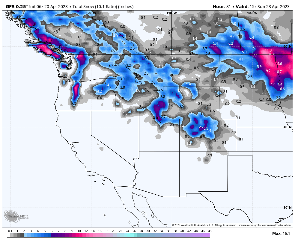
Amounts? 8-12 for the Washington Cascades (Northern areas of WA, Central-northern Oregon). 4-7 inches Tetons. 7-10 inches (Wasatch Range), 5-11 inches (Wide area of Colorado with the western areas favored).
This winter has simply been relentless in offering powder nearly every week (Or every day in February and March).
Below: Total snowfall will likely exceed this map at 10:1 with colder temps and higher snow ratios it's likely higher amounts will be found, especially in the Rockies. The PNW will do well with leftovers aimed at a wide area of northern Idaho and most of Montana. Colorado and Utah will likely be in double digits by Saturday.

Announcement: Today is your last day to grab the pre-season Ikon Rates here.
Please donate for powder forecasts here. If you swag us $100 or more, we are happy to send you a swag package (Shirt and stickers). We depend on your support and if you have read this far, you likely have scored powder this season. Please take one of our last opportunities this season to feed our powder bank. We also have a new Powder store, so you can also purchase some swag. Thanks for following Powderchasers and for your support for Pow.
Powderchaser Steve - Instagram @powderchasersteve


