Announcement: This is an initial rollout of out new website (Pre release). We are looking for feedback. Please visit the store and and let us know what you think. There will be many more items coming in the future. Also, if something does not work email us at powderchasers1@gmail.com.
Forecast Summary: Very cold temps are bringing snowfall to the coastal range mountains in the PNW, with Mt Baker Telemetry (Closed) showing 17 inches. Unsettled week with a few breaks as several weak or moderate disturbances move into the Rockies mid and late week.
Forecast:
On Saturday Powderchaser Steve chased to Vail where 9-11 inches fell late Saturday night. Our last forecast had Vail as a strong wildcard "Just a hunch" and it delivered. Vail Ski Patrol popped the ropes to the back bowls (Had been closed). Temps previously were very warm so the crust layer was in full force unless you scored a groomed run on the back. The Front side under Northwoods or down Riva Ridge rode very well. Most of the Front Range was asleep (Including myself) as I missed first chair/gondola but leaving Boulder at 6 AM, I still scored 5th Gondola. During the mid winter that would have been disaster on I-70. Eldora who was also highlighted on my last post scored a storm total of 12 inches with 50% falling on Friday. Eldora finished the season out with a mid April bang.
We are beyond Mid April, and current conditions in the PNW are more representative of January. Very cold temps brought 4-6 inches to Whistler (Mid Mountain) on Sunday. As of Monday morning some light snow was noted on the cams even at the base area.
The automated snow sensors around Baker are showing 17 inches in 24 hours (Currently Baker is closed). Much less snow fell further south
Below- Mt Baker NWAC telemetry showing 20 degrees at the higher elevations of Baker and 17 inches of snow since 6AM Sunday. WOO HOO. We wish they were open, as we would have chased there.
 .
.
The pattern remains unsettled with additional waves of light to moderate snow for the PNW nearly all week intermittently. Snow increases again late Monday night into Tuesday. This will favor the northern Cascades and drop south into Oregon landing some decent totals for those areas (Northern Oregon might see higher amounts). Check to see what resorts are open before chasing. More light or moderate snow is possible late this week.
The Rockies are on the cusp of leftovers with the McCall area mountains seeing a decent blast for Tuesday extending into Missoula (MT Snowbowl). Amounts could approach 5-11 inches (See what resorts are open or allow skinning). For Utah most of the action occurs during the day Tuesday with the highest amounts near the Idaho border (Southern Idaho or northern Utah) who could land 5-11 inches. Further south in the Cottonwoods I am less optimistic with generally 4-9 inches (Storm skiing). With the warm temps on Monday and a hefty cool down Tuesday it might ride a bit funky, especially south facing terrain. If Beaver Mountain was open, I would watch for some options near Logan or in southern Idaho along I-15 (Just a hunch). The European is an outlier showing less snow further north in Utah and a bit more for the Cottonwoods. We shall see.
The Tetons will be in the flow primarily Tuesday morning to Tuesday evening with 4-9 inches of snow (Resorts are closed). The Backcountry might ride well, especially late Tuesday or early Wednesday.
Colorado grabs light or moderate amounts late Tuesday to Wednesday. The focus seems to be from Steamboat and south over the western side of I-70 (Vail is a wildcard) towards Aspen (CB wildcard). Winds are primarily SW (Not great for I-70) but there are hints of a brief period of NW flow for a short period Wednesday morning (Might sneak up on Vail Pass). This is not going to be a deep storm.
The extended brings another wave into Utah on Thursday and into Colorado late this week or early weekend. The models are in flux on amounts. Some models show a decent storm for the Front Range and Divide while others much less. It's also possible that New Mexico scores some late April powder. Utah might see higher amounts with the late week storm versus the early week teaser.
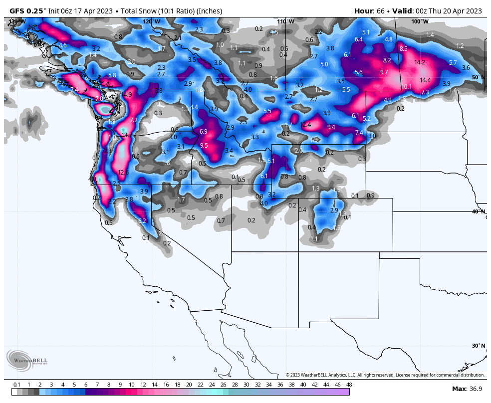
Below: Total snowfall (Storm #1) through Wednesday afternoon for the west. Focus is in the PNW and Northern California (Just north of Truckee). Idaho, northern Utah are next on the list with moderate amounts (Heavier in Idaho). The storm track takes the energy north into the Dakotas and central Canada.

Below: The National Blended model showing a healthy 2 day storm total for Colorado on storm #2 late this week or weekend. We are not buying into this just yet. Other models show a much different solution, however the NBM is a blend of multiple model outcomes. This blended model is the most bullish of the other solutions and shows a decent storm on the Continental Divide of Colorado extending west along I-70. Confidence is low at this point.

If you currently hold an Ikon Pass or are thinking about 1 for next season, rates go up in 2 days! You can purchase the lowest rates now here
Thanks for following Powderchasers and supporting our sponsors- Tire Rack, Ikon, Mountain Collective, Selkirk Powder Snowcat Skiing, Alaska Backcountry Guides (Heli), Indy Pass, Zoleo, Beaver Mountain (Longest running family mountain in the USA), and Unofficial Networks.
Powderchaser Steve - Follow on Instagram @powderchasersteve


