Summary:
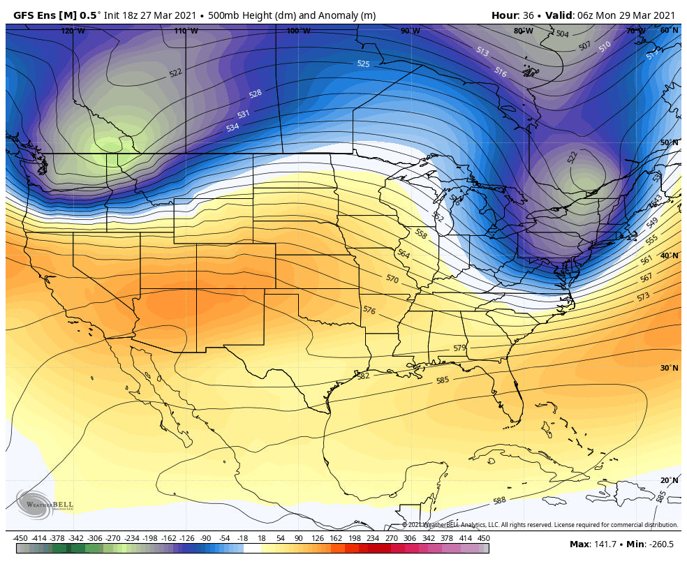
A vigorous low-pressure system will impact BC, and the Pacific Northwest Saturday night through Monday. While snow will be deep, the winds are the primary concern for chasing powder. The Rockies get the leftovers in the central Panhandle of Idaho and northern Montana.
Trip Report: The past few days had some decent chases. First on Friday Wolf Creek was skiing 10-15 inches deep for the first chair. It's been a while since I visited the Wolf. The storm totals for Wolf Creek was 29 inches over 3-4 days. Here are a few summary points.
* Earlier line ups at the chairs since some some lifts spin by 8 AM (The out of town folks seemed to like that early opening chair and it spreads folks out).
* Still has the small ski area vibe to it (That's a good thing). I was able to park right upfront early in the morning.
* Hike terrain up Alberta Peak is great and not busy during storms (local crowd).
* Ski Patrol rocked during this storm cycle keeping most hike terrains open each day.
* Some of the best food of any small mountain ski area (Green Chile was amazing-10 Plus on spice). Nice selection with outdoor seating.
Below: Pic from @powderchasersteve via Instagram of an untracked run on Alberta Peak Friday. Not the best shot from my iPhone! Deep and fun.

Then on Saturday, while folks were sleeping, I chased to Vail where the upper mountain had 5-7 inches of high-quality powder. Just enough to fill in most of the shark fins that will barely evident on south-facing. The conditions were actually really good. \"Sleeper Pow\" day. Ripper snow on low-angle slopes.
Below: Powder at Vail on Saturday @powderchasersteve via Instagram

Forecast: The next 48 hours feature a strong area of low pressure that is just beginning to impact Whistler. The BC mountains including Whistler will score deep powder at the upper elevations with rain possible at the base (12 inches plus). Interior BC will see impacts late Saturday night or early Sunday (Moderate snowfall).
The Cascades of Washington is favored by 10 AM Sunday with the North Cascades (Mt Baker) grabbing 7-10 inches during the day (SW winds). That system drops over the Central Cascades of Washington late AM (Stevens and the I-90 corridor) with heavy precipitation rates. Storm ski Baker nearly all day Sunday and hit Stevens or Alpental by noon. Less snow will be falling further south until Sunday afternoon or evening when winds shift to the west, northwest pushing higher precip rates into Crystal. Caveat: Strong winds will likely be an issue by the afternoon Sunday at many Ski Areas with lift impacts likely. Temps are on the warm side so snow quality will be dense (Smoothing, buff, type). Cooler temps possible in the northern Cascades as quality improves by late AM Sunday or afternoon. Later in the storm cycle sees the best quality snow but still windy.
A Puget Sound Convergence Zone will set up over the central Cascades favoring Stevens Pass Sunday evening (Heavy snowfall rates). Temps will drop and quality will be primo (Dry blower). Caveat: Winds are very strong Sunday afternoon through at least Midnight. Winds might play havoc on snow quality (Pessimist). The optimist tells me that buff snow might be followed by cold frosting for Monday morning. Winds will be extreme Sunday evening and strong after midnight, decreasing at some point Monday. Further south, Crystal and the northern mountains of Oregon (Timberline) should all see snowfall Sunday PM to Monday morning (5-10 possible).
Below: Total snowfall by late Monday over the Cascades. The northern Cascades will win on Sunday while the central Cascades will be deeper for Monday (Puget Sound Convergence zone- Cold air with westerly flow causing an increase in lift and moisture depositing over the mountain ranges east of Everett). Oregon is favored for Monday morning with the northernmost areas in play.

Elsewhere in the west, decaying moisture dives into the central panhandle of Idaho for Monday morning (moderate amounts central regions, lighter to the north near Sandpoint) and trickles over northern Montana (Whitefish) and eventually over the Tetons (Light snow).
Below: Total snowfall through Monday night for the west. Moisture from the PNW weakens and brings moderate snowfall for the central Panhandle of Idaho and northern Montana. Lighter snow likely for the Tetons.

Extended: The models show high pressure taking hold over much of the west after this storm system. High pressure might buckle somewhat over BC and the PNW by the end of the week (To be determined). The Rockies will stay dry.
Below: High pressure over the Rockies much of next week with a possible trough entering the PNW late next week (April 2nd)

Below: April 6th might bring another trough to the west that takes a coastal route over the western regions including the Sierra. Let's hope this signal holds up.

Enjoy the powder everyone! Please support Powderchasers by sending us a donation from the website or joining our concierge program. Please support our sponsors! Selkirk Powder may have spots on the Heli this week in Northern Idaho!
Powderchaser Steve


