After 4 straight days of snowfall, the precipitation in California wrapped up this morning.
Tuesday will be dry with mostly sunny skies, low winds, and temperatures in the mid-20s; picture perfect day for skiing, especially after 4+ feet over the last few days! Wednesday morning will start off cloudier and a bit warmer. Snow will start in the afternoon, for most resorts likely after the lifts close for the day. By Thursday morning, here are what I see as reasonable totals for the area. Keep in mind this storm is still some ways away, so numbers will likely change for better or for worse before then:
- West Tahoe (Palisades, Sugar Bowl, Kirkwood): 6-10”
- Central Tahoe (Northstar, Homewood): 6-8”
- East Tahoe (Mt. Rose, Heavenly): 4-6”
- Mammoth: 2-4”
This is quite a short-lived storm; most of the snowfall will be wrapped up by the time lifts open on Thursday except for maybe Mammoth, which could continue to see light snow during Thursday morning. Wind speeds look low, so upper mountains will be good to go once patrol teams are finished with their avalanche mitigation.
Unfortunately, it’s going to get very dry in California to close out the month. Some models are indicating no snow for 10+ days after the storm on Thursday. We’ll see if this pans out, but a large ridge building over the west is likely going to make it very difficult for any substantial moisture or storm energy to make it to California:

Above: ensemble geopotential height anomalies for the last 10 days of January. Warmer colors are less conducive for snowfall.

Above: ensemble precipitation departure from average, last 10 days of January. Looking dry...
The good news is that temperatures will remain on the cooler side, which should help preserve the snow quality.
Looking into Utah, there is a storm system that will drop snow between Monday afternoon and Wednesday afternoon.
Temperatures allowed the snow quality to remain excellent overnight and will stay between 15:1 and 20:1 for the rest of the storm, which is nice and light and will for great skiing this week.
Precipitation rates will ramp up throughout the day on Tuesday, peaking in the afternoon. During the ski day on Tuesday, I see Cottonwood resorts picking up 2-4” and PC/DV picking up 1-3”. Snowfall will continue to decrease overnight, and Cottonwood resorts will see another 1-4” with 1-2” at PC and DV. Check out the HRRR forecasted storm total that brings light to moderate snow favoring the resorts along or south of I-80 between Tuesday AM and PM.

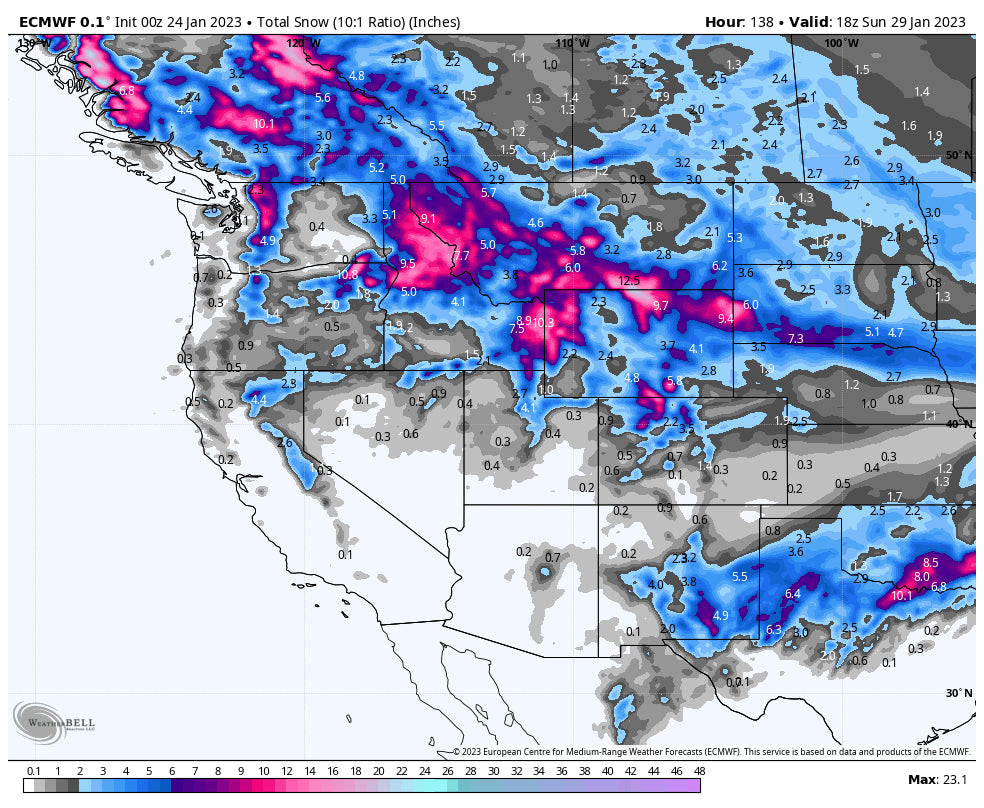
The next opportunity for snow in Utah will come on Sunday, January 22nd with a dynamic clipper system from the north. As of right now, it’s looking like this could bring totals in the 4-8” range, although details remain fairly uncertain.
This week in Colorado, this storm will also last through Wednesday afternoon/evening. Resorts in southern/central CO picked up respectable totals last night:
Snowfall on Monday plus Monday night in Colorado amounted to:
10” Purgatory
10” Silverton
9” Crested Butte
4-8”+ Wolf Creek
5” Sunlight
4” Snowmass
I’m expecting 1-2” for the central mountains and 5-10 over the course of Tuesday especially in the southern regions of Colorado. Snowfall rates will increase into Tuesday afternoon as the day goes on Free refills anyone (Storm ski Tuesday). Totals should exceed a foot in the southern mountains by later Tuesday evening.
The snow north of I70 will start on Tuesday evening as the winds shift from the SW to the NW On Tuesday night, I see northern mountains (including Summit County) picking up 4-8”. However, I think this is a conservative number; some models are showing some embedded bands of heavy snowfall on Tuesday night that could push totals past the 8” mark for sure. Central mountains will see 3-7” and southern mountains are looking at just a few inches (1-3”) on top of an already respectable storm total.
During the day on Wednesday, light showers will stick around in the mountains, especially in central and northern Colorado. Don’t expect much accumulation from these showers, maybe an inch or two. Check out the HRRR forecasted storm total: There are bands of heavier snow that might set up along Vail Pass, Summit County and even the Continental Divide closer to the front range. Wednesday morning will be a powder day for much of the I-70 corridor.

Some models are hinting at a small system working its way through on Friday. This system could bring a few inches if it materializes, but it’s still a bit too soon to tell how much upside there actually is for Colorado from this storm. Below is the Canadian (left) and GFS (right) side by side... notice the Canadian keeping the precipitation relegated to the south whereas the GFS has a much more widespread system:

Beyond that, the next opportunity for snow in CO will come on Sunday. Again, a lot of uncertainty here; some models have light showers in the north and others have a full on dump from north to south. Stay tuned for another forecast with more detailed information.
ANNOUNCEMENT
Powderchasers and our forecast staff are supported by our readership, so if you have not donated, please do so here or join our powder concierge program where we provide 1:1 trip planning for chasing, last-minute custom forecasts, and the best pow day of your life. Support our sponsors and be sure to follow our Instagram and Facebook page @powderchasers.
POWDERCHASERS FORCAST TEAM.


