This post is sponsored by Skis.com who has up to 70% off on certain gear. Support family run ski shops! Please check them out.
All eyes are back on the West this week as a late-season trough digs into the region, bringing major snowfall to California, Utah, Colorado, and Wyoming.
The storm has already moved onshore in California, where flakes are already flying in the Sierra. Check out the scene from the base of Palisades below:

Looking ahead, precipitation will continue to increase on Friday afternoon into Friday night, with snowfall rates peaking around 11pm.
By Saturday morning, we're looking at 7-12" for resorts along the Sierra Crest (Palisades, Sugar Bowl, Kirkwood), 4-8" at resorts on the eastern side of the Lake (Mt. Rose, Heavenly), and 6-9" for central Lake resorts (Northstar & Homewood).
Below is the HRRR projection for total snowfall by 7am Saturday. Notice the deepest totals being found along the northwest of the Lake along the Sierra Crest (Palisades & Sugar Bowl). Mt. Rose also scores decent high quality snow due to its high elevation:

The snow in Tahoe will be good, but Mammoth will be the real winner on Friday night. Mammoth's high elevation means low temperatures and low-density snow, and they're located right in the precipitation bullseye. Mammoth is likely looking at 15-20" of fresh snow by Saturday morning. Again, the snow quality will be noticeably better at Mammoth than in Tahoe.
With low winds on Saturday, there's a good chance that resorts will be able to open upper-elevation terrain after avalanche control work is done.
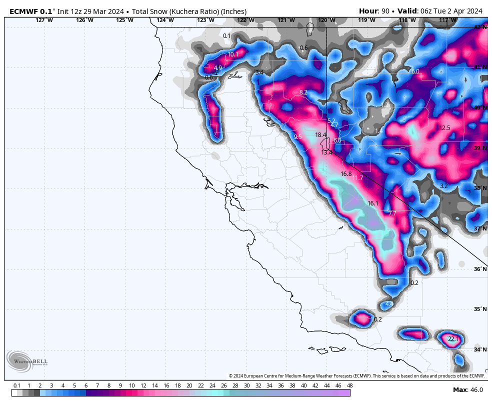
Snowfall will linger in the northern Sierra near Tahoe (not Mammoth) through Sunday afternoon and will bring another 4-8" to Tahoe region resorts. Below are the ECMWF (left) and GFS (right) storm totals by Sunday evening. Notice the good agreement on the central and southern Sierra being favored (Mammoth chase):

The moisture from this storm moves east and also hits Utah, kicking off an impressive spell of snowfall that will last into early next week, likely into Monday evening.
The snow on Saturday and most of Saturday night will be anomalously dense due to warm temperatures in place. However, the snow quality will increase dramatically early on Sunday morning with a steep drop off in temperatures, meaning the snow quality will be best on Sunday and Monday. Sunday will be the windiest day and could prevent resorts from operating their upper-elevation lifts. Below is a look at the moderate lower-atmospheric winds out of the southwest that may affect upper-elevation lifts on Sunday:

By Monday evening, we're looking at 16-24" for resorts in the Cottonwood Canyons, 12-20" at Park City, and 8-12" for northern Utah resorts (Snowbasin, PowMow). Check out the projected snowfall from the NBM by early Monday afternoon:

Colorado will also get hit, with central and northern CO seeing light on-and-off snowfall until Sunday morning and then all regions seeing a bigger surge of snow from Sunday morning through Monday night.
Between Sunday morning and Monday night, the second surge will bring 2-4" at Steamboat, 2-5" for I70 resorts, 3-6" for Vail, 4-7" for Snowmass & Crested Butte, and 10-15" for Wolf Creek. The second surge will be accompanied by low temperatures and high quality snow. Below is a look from the ECMWF of the second surge by Tuesday. Notice the highest totals in the San Juans in the south:

The Tetons will also see snow, with a small push of a few inches of snow on Saturday before the main surge hits on Sunday morning and lasts through Sunday night. By Monday morning, Grand Targhee will have picked up 6-12" and 5-10" at Jackson.
Early next week, a large ridge builds over the west before our next system sweeps into the Pacific Northwest on Wednesday. Check out the ridge that will be dominating the west early next week:

This looks to be a very extensive storm, bringing precipitation to every corner of the West through next weekend. Below is forecasted precipitation amounts from this storm from the ECMWF (left) and GFS (right) models. Notice basically everyone winning with big totals in the PNW, Idaho, Montana, and potentially California:

If you want to Heli ski our sponsor Alaska Backcountry Guides still has 3 seats open from April 14-20. Snow is in the forecast! Any bookings earn you a free concierge package for next season at Powderchasers! Mention PC when booking.
HELP US OUT! Please donate here to Powderchasers if you have taken advantage of our free forecasts. This is our number one source of revenue. Free swag for you on all donations from $50 and up. $100 donations grab you a custom shirt also!
We have new Powderchasers shirts fresh off production for sale currently for just $32 (Front and back powder)


Don't forget if you want to chase powder to the best locations every time, join our concierge package here. This provides custom 1:1 consults. You won't miss the deep.


