This post is sponsored by Skis.com who has up to 70% off on certain gear. Support family run ski shops! Please check them out.

Sierra
The Sierra came out a bit short on snow totals with generally 7-10 inches at most resorts (Our original forecast was 10-15). Sugar Bowl reported 10 inches and was highlighted on our last forecast with the models showing higher totals on 80 and west. One surprise was at Mammoth where numbers were higher than we expected (12-14). As we forecasted the temps remained warm through the majority of the storm cycle and with strong winds we would expect surf conditions. The next storm will be much higher quality.
Tetons-Wasatch- Colorado
That storm moved over the Tetons on Thursday morning and Brought 10 inches to the upper elevations at JHMR (6AM to 2PM) and 6-7 inches in the Cottonwoods (1PM to 5PM) and even higher totals to Snowbasin. Snow is continuing in Utah Thursday night with another 2-6 inches possible in the Cottonwoods for Friday turns. Most of the moisture will be east of the area by 9PM.
Below: Snowbasin had a great storm day on Thursday.

Elsewhere in the west, light snowfall will be falling in the Cascades especially south of Crystal towards the Oregon border but we don't see any highlights.
Colorado will be on the uptick on Friday morning with a narrow band of snow showers impacting areas near Steamboat perhaps reaching Aspen with a stretch further south (CB wildcard). Most of the snow is confined to areas on the far western I-70 corridor extending up to Meeker, Hayden and Steamboat. Amounts will range from 4-8 inches. Temps are warm and the snow will be on the surfy side.
Below: Scattered snow showers from later Thursday night to midday Friday will impact isolated areas of Colorado favoring the western corridor or areas north to Steamboat. Aspen is a wildcard. Temps are warm with the most snow confined to upper and mid elevations. We don't expect totals to exceed 8-10 inches. Quality will be surfy at lower and mid elevations with some rain possible below 7000.

Storm #2- Sierra- Rockies
The Sierra cranks out another 8-14 inches from Friday to Saturday. This storm begins on Friday with 35% of the totals falling during the day and 65% at night into Saturday. The latest models are showing higher totals likely near mammoth or the southern regions of Lake Tahoe. Mammoth could see 12-18 or more. Areas north appear to be in the 8-14 inch range. Temps are cold enough for decent totals at the bases, especially Mammoth Lakes.
Below: Storm totals in the Sierra will be in the 9-14 inch range with highest totals in the southern Sierra. This storm will be colder than the preceding storm and provide decent quality and much lighter winds.

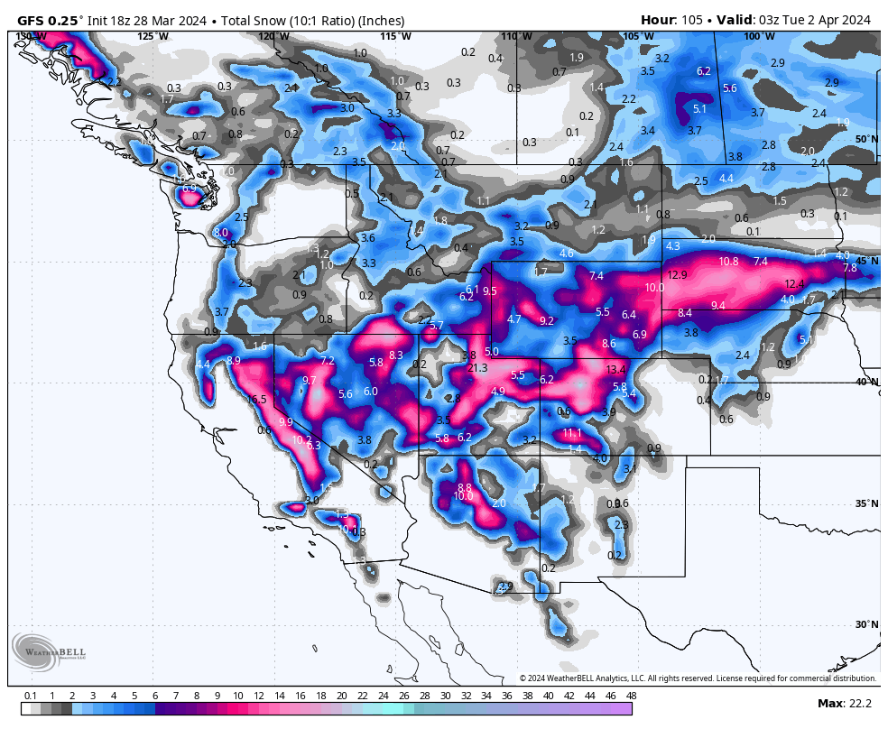
Ample moisture will approach the Rockies as early as Saturday morning and continue with several waves through Sunday/Monday from the 4 corners and just pinching the Tetons to the north (Higher totals south).
Below: 24 hour snowfall totals looped from Saturday to Wednesday April 3. The date-day is in the upper right corner of the map. The take away is initial double digits for the Sierra this Friday-Saturday spreading into the Wasatch Saturday AM to PM, and Colorado by later PM Saturday to Sunday.
The first wave this weekend seems to drop south over the 4 corners bringing some moderate totals to the San Juan range, especially in Arizona (ASB). Temps are cool initially with wrap around moisture feeding into Utah Saturday morning. Temps warm Saturday so it might end up a bit upside down (?).

There is a 2nd wave if you look closely above that moves in from Sunday to Monday. This system seems a bit deeper for both Utah and Colorado. A broader area of the I-70 corridor in Colorado might see higher totals than the earlier waves. This wave is colder than the Friday/Saturday wave.
With so many different opportunities to score these waves we will have to issue an update in the next few days. Please check out our sponsors that support us
If you want to Heli ski our sponsor Alaska Backcountry Guides still has 3 seats open from April 14-20. Snow is in the forecast! Any bookings earn you a free concierge package for next season at Powderchasers! Mention PC when booking.
HELP US OUT! Please donate here to Powderchasers if you have taken advantage of our free forecasts. This Is our number one source of revenue. Free swag for you on all donations from $50 and up. $100 donations grab you a custom shirt also!
We have new Powderchasers shirts fresh off production for sale currently for just $32 (Front and back powder)


Don't forget if you want to chase powder to the best locations every time, join our concierge package here. This provides custom 1:1 consults. You won't miss the deep.
Enjoy the powder, everyone!


