SUMMARY
The final decent wave (Storm #3) is going to bring yet another powder day to the Pacific Northwest for Friday morning. What's ideal is that all 3 storms this week have produced mainly overnight pow making it an ideal chase location to close out the week. The interior of BC continues to get light snow showers that will increase by Friday/Saturday. That Trough splits south over the Sierra for Saturday with another branch splitting east over the northern Rockies. The Rockies stay warm and dry until temps cool slightly Sunday bringing snow back to the Tetons and to a lesser extent the Wasatch in Utah. The extended forecast shows a deep trough possible for the San Juan Range mid next week. The northern Rockies might get deep by the end of next week.
FORECAST
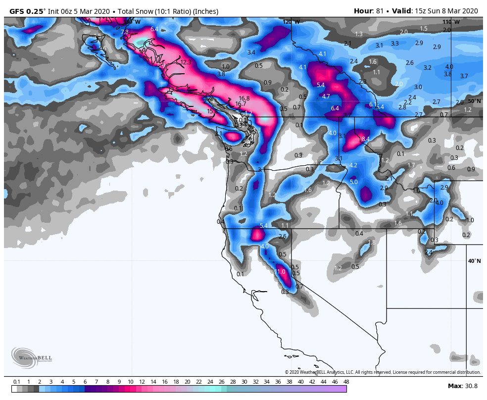
Snow will begin falling in the North Cascades Thursday. Most of the models agree that 7-10 inches will be likely by first chairs at Mount Baker by Friday morning and perhaps 3-5 inches further south towards Stevens. I have low confidence in any deep dumps outside these regions. Whistler is likely to land in the 4-8 inch range.
The system in the Pacific Northwest splits with a southern branch heading into the Sierra for storm skiing on Saturday with some freshies expected for Sunday morning. Currently, amounts focus primarily in the central or northern portions of the Sierra with much less to no new snow in the chase forecast for the southern areas. Head north to Alpine Meadows, Sugar Bowl, Squaw, or perhaps Heavenly who will likely see 4-8 inches by late Saturday. Winds will be strong Saturday so it's possible that upper lifts remain closed at some points Saturday making it possible to ski the storm total either late PM or early Sunday. That puts both Saturday and Sunday as possible good days to ride powder. The bases will see less snow due to warmer temps with the summits in the upper ranges. Remember to head north for the deepest pow.
The northern branch of the system to impact the Pacific Northwest Friday moves into southern BC and the northern Panhandle of Idaho increasing the odds of some moderate snow to impact these areas. Precipitation for the Rockies increases for Saturday night into Sunday primarily impacting the Tetons (Light to moderate amounts possible for Sunday morning). The Wasatch will see light snow on Sunday. Colorado will also see light snowfall focussed on Sunday mid-morning to early Monday.
Below: Total snowfall for the West through Sunday morning showing the highest amounts in the PNW, moderate for the interior of BC, and a small area of decent freshies in the northern Sierra. The Tetons get teased Sunday morning with less falling over Utah.

Skip ahead to the extended forecast for an interesting period of southern storms followed by a chance of a deep northern Rockies storm.
EXTENDED
The models show decent subtropical moisture streaming up from the southern California Coast in the Tuesday-Wednesday time period. This is likely to bring a decent event to southern Colorado in the midweek period (Tuesday night or Wednesday). Southern Utah is a wildcard.
Below: A southern trough with a decent tap of moisture from the Pacific makes its way over southern regions of the forecast area for mid-next week. This might bring decent snow to the San Juan Range.

Meanwhile, as temperatures have stayed warm for many of these systems, a cold front (Finally) makes it's way down from Canada late next week bringing in a glimmer of hope for a decent cold storm to impact the northern Rockies from Montana, Wyoming, Utah, Idaho, and Colorado. Next Weekend is a long way off for any accuracy, however, the odds are increasing for a decent dump.
Below: Low confidence this far out, with the ensembles showing a cold front and decent trough, likely to impact the northern Rockies late next week or the weekend.

Enjoy the powder everyone!
Powderchaser Steve


