SUMMARY
The Pacific Northwest will be in the bullseye of a cold storm, Friday night through Saturday. Leftovers will filter over the Rockies and Sierra for Saturday night and Sunday. It's possible that some areas sneak out a moderate powder day in the Rockies for Sunday. Even the Sierra could produce some fluff that has not been seen in a very long time.
FORECAST
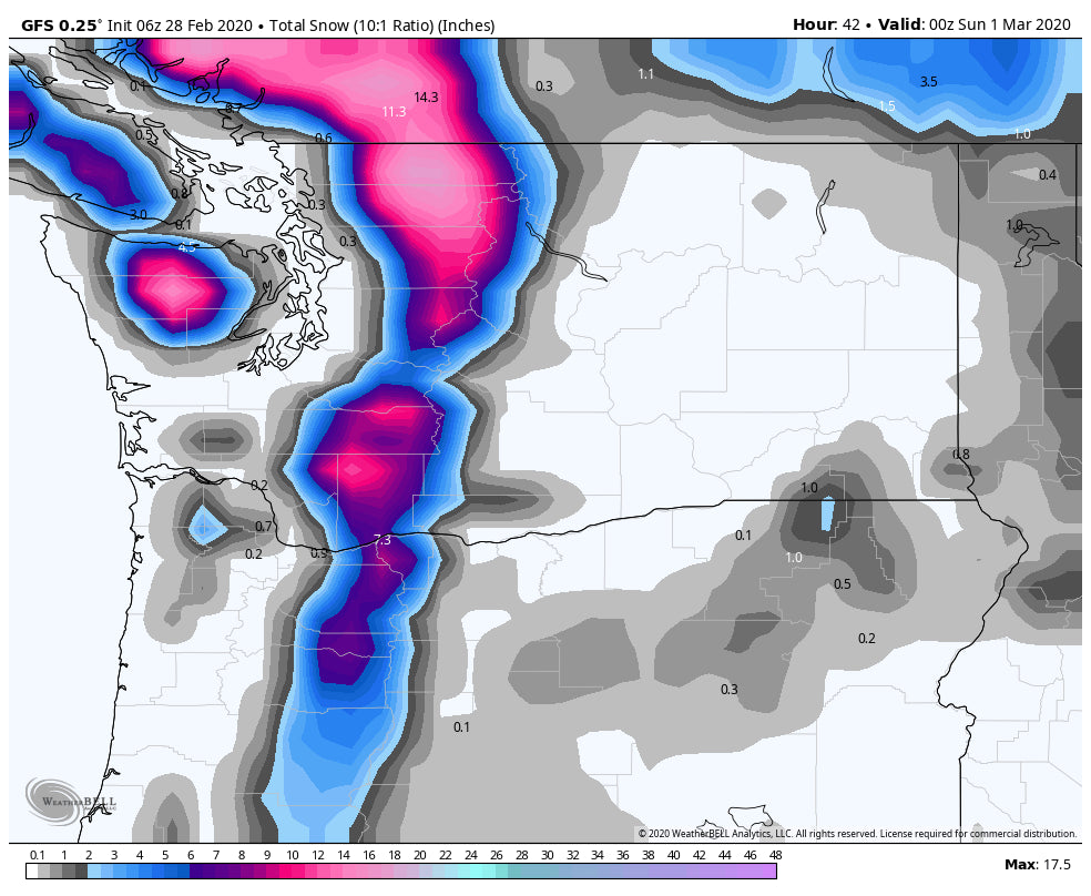
Models continue to advertise with good agreement of a cold storm for the PNW. Warm temperatures on Friday will plunge snow levels from 4500-6000 feet to 2500 feet by early Sunday. Temps will continue to drop through the day. The heaviest snow will fall in the northern ranges near Mount Baker where its likely that 11 inches is on the snow report at 6AM. Another 3-7 inches will fall during the day. Further south expect wide areas of 4-8 inches at Stevens and Alpental with perhaps similar amounts in the south Cascades. The Good: Heavy snow overnight into Saturday. The Bad: Warm temps preceding the cold front might form a crust layer in spots?
Below: Warm temps in the PNW for Friday (Above freezing at 4800 feet).

Below: Much colder temps for Saturday in the PNW (-4C at 4800 feet)

Below: Total snowfall for the Cascades through late Saturday. Highest totals are in the northern regions.

For the remainder of the west, the Sierra gets teased late Saturday night plunging temps from the 50's to the 20's for Sunday. The temperature gradient drop rapidly destabilizes the atmosphere so roadways at upper elevations of I-80 could become slick rather quickly with heavy snow falling for a short duration after 10PM Saturday. Expect 2-5 inches at many of the Tahoe resorts with up to 8 inches at the summits near the Crest.
In the Rockies, a general trend is for 3-6 inches favoring the northern ranges from the Tetons, Wasatch, and north/central Colorado Sunday-Monday. The Wasatch is likely to be on the upper end of that range with a few models hinting at higher amounts in some isolated spots. While this is not a going to be a deep storm I would not be surprised to find 7-10 inch totals in the Cottonwoods by late Sunday evening (Wildcard). The best days to ride powder will be Sunday morning in the Tetons (Light, perhaps moderate amounts) and mid morning for the Wasatch (Snowing). Yesterdays models pointed to higher amounts in the northern border areas of Utah and Idaho (Beaver Mountain). Today's models decreased storm totals in general with 1 model showing higher amounts near the Cottonwoods. The winds are from the North which may under produce in the Cottonwoods and over produce elsewhere. I'm really not sure. There is still uncertainty with this storm.
Below: American Model (GFS) is the most bullish with 3-6 inches for the Tetons (Higher amounts in the Wind River Range) and similar amounts for Utah. The 9.4 inches in Utah is our only outlier leading me to believe someone will over perform by late Sunday (Cottonwoods or even Summit County, Parleys Summit, or the Canyons). The other models show less snow.

Colorado will benefit Sunday morning into Monday with generally light or moderate snowfall. The models show 4-8 inches are possible by late Sunday night favoring the northern and central mountains. Storm ride on Sunday and grab some additional powder for Monday. Northerly winds might favor spots along or just north of I-70 near the Front Range (Berthoud Pass, Winter Park, Loveland). Your best times to ride will be late Sunday or early on Monday. More details will be issued on a future chase forecast.
EXTENDED
In looking for deep snow, the pattern will favor the Pacific Northwest and western portions of BC. A warm up on Monday/Tuesday (PNW) will bring higher density snow to the Cascades that increases in intensity mid next week. Heavy snowfall is likely in the Cascades for the midweek period, however warming temps will decrease quality initially at lower elevations until a cooling trend late next week. It's possible that the northern Cascades score several feet of snow by the end of next week.
Please join our Powder Concierge for specific chase forecasts and a dedicated Forecaster for deep powder.
Powderchaser Steve


