
2 Low-pressure systems will bring snow to the west. Significant moisture is streaming into the Southwest (Hurricane Priscilla) while colder air in Canada drops south. Flooding rains will impact the SW over the next few days. A cold front further north brings moderate to heavy snow to Alberta, Canada, the NE Cascades, and areas of Montana. Storm totals in these regions will likely exceed double digits. Cold temperatures continue into next week.
Highlights
- NE Montana- Glacier National Park- 5-10 inches
- Gallatin Range (Bridger, Big Sky) 6-12 inches
- NE Cascades (Mazma, Twisp Mountain ranges) 7-15 inches
- Northern Idaho-5-10 inches
- Alberta Canada Resorts (9-15)
- The Southern Sierra Range is on watch for early next week.
Timing:
Saturday PM to Sunday, Northern Rockies, Alberta, Canada
Tuesday PM to Wednesday Sierra (Wildcard).
Areas south of Yellowstone near the MT/WY border will likely see lower totals, while the Jackson Valley might see its first flakes of the season (Lower elevation tease). Snow levels in the northern Rockies and Cascades plummet to 4-5,000 feet.
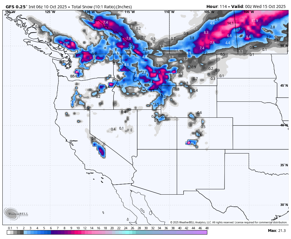
Below: Total snowfall through Tuesday, October 15th, with both low-pressure systems combined. You can see the emphasis is on the northern Cascade region of eastern Washington, Alberta, Canada (Marmot Basin, Banff), and a wide area of western Montana. The Tetons see lower totals, with even less towards the Wasatch. The Sierra gets into the action early next week with a bit more uncertainty (Tuesday/Wednesday storm).

Below: Low #1 is centered over the northern Rockies this weekend, while the 2nd low rapidly moves down off the coast of California early next week.

Below: Total snowfall through Sunday, October 12th, with the highest totals over Montana.
 Below: The Pacific Northwest benefits this Saturday/Sunday with generally 10-14 inches over the NE interior Cascades, 3-5 on the western Cascades, with moderate snowfall expected for Schwietzer Mountain (5-10). Pass-level snow is possible.

Storm #2 (Next week)- Tuesday-Wednesday
Below: The 2nd low-pressure system due on Tuesday/Wednesday next week skirts the CA coastline and should bring some decent totals to a few areas of the Sierra Range. The models are pushing higher totals towards Mammoth versus the core of Lake Tahoe. NE winds are noted on the models, which might not fare as well for the Sierra Crest versus areas that sit just east of the Sierra ranges. Currently, the models are bullish for Mammoth. This needs to be monitored.

ANNOUNCEMENT: All of our Concierge Packages are on sale (Custom chase planning to nail the deepest powder) until the end of October. Buy a package now and save up to $100. Check out our new long-sleeve shirts that just arrived and are on sale this month. Buy a long-sleeve shirt and we will throw in stickers for free.
Please support Powderchasers with a donation here.
We support the powder community with these free forecasts.
Powderchaser Steve -@powderchasersteve -Insta


