
The last storm highlighted Canada (Alberta and eastern BC were deepest) with the cold front that swept through the Rockies on Saturday night. Some storm highlights are below from the last storm.
The Previous Storm in the Rockies delivered a potent cold front and snowfall.
Bridger Bowl: 8-11 inches
Grand Targhee: 6-11 inches
Big Sky: 8 inches
Fernie: 6 inches
Alta: 1-3 inches
Park City: 1-3 inches.
Below: Bridger Bowl on Sunday morning.

Below: Fernie Ski Resort on Sunday morning, October 12th

Below: Grand Targhee had 5-11 inches for Sunday morning, and folks were skiing powder with Snowliage.

Upcoming Deep Powder:
The next low-pressure system will send a cold front along the California coast and bring double-digit snowfall totals to the Sierra Range, peaking on Tuesday. The trajectory of the snow will start in the south and spread north. The southern Sierra seems a bit favored on this storm; however, decent totals should also creep north as far as the I-80 corridor. I would place my best odds that Mammoth, China Peak, and perhaps June Mountain do very well. Northern areas will also see snowfall. Lake Level snow is likely (Lighter totals).
Expected Snow Totals for the Sierra.
Mammoth: 12-15 inches (Higher totals at the summit).
Kirkwood: 8-14 inches
China Peak: 8-14 inches
Palisades: 5-10 inches
Homewood: 5-10 inches
Below: You can see the coldest (dark greens) air originating from the Pacific Northwest Coast and sliding southwest of the mountain ranges before sweeping inland over the Sierra. The cold front weakens as it spreads north over the Rockies midweek.

Below: Snow fills in from south to north beginning late Monday night. The GFS shows snow reaching the I-80 corridor late Tuesday morning, with the southern ranges earlier (Late Monday night). You could chase from south to north on Tuesday.

Below: University of Utah ensembles showing widespread solutions for 10-16 inches for the Mammoth Mountain base area. The summit will likely exceed these totals.

Below: University of Utah ensembles showing averages of just over 10 inches for Palisades; however, there is quite a bit of discrepancy with many models showing less (The lines below the bold mean). This has some risk and is all dependent on how far north the low tracks from the Southern Sierra. I have 5-10 inches on my forecast.

Rockies:
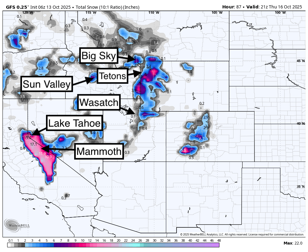
Below: Total snowfall per the American GFS shows snow spreading from the Sierra on Tuesday night into the Rockies in the midweek timeframe. This is one of those storms where the moisture is getting wrung out by the Sierra Range, and leftovers will be less over the Rockies. The highest totals might push just north of the Wasatch (light snow) and impact the Tetons (moderate snow) and southernmost areas of Montana. Southerly flow can sneak up some surprises over Sun Valley, so I have also put them on this map (Light totals).

Colorado Highlight:
A storm system will impact Colorado today (Monday) with a narrow band of cold air noted along the Divide along 285, Leadville, and south along the Collegiate Peaks Range.
Below: Total snowfall in Colorado Monday/Tuesday will tease a few areas south of Summit County and perhaps north towards Red Mountain Pass at the peaks. The areas near Leadville or along the eastern Divide might see some snowfall below 8K feet. Areas in the Southwest see higher snow levels.

Below: Temps in Colorado today (Monday) are very warm in the western areas (snow levels above 10K feet) with a cool pocket noted on this map just east of Summit County. The map is at 10K feet in Celsius.

The Chase:
Highest confidence exists in the Sierra Range to chase on Tuesday (Storm ski). I would emphasize areas in the southern Sierra for an excess of double digits. Areas along Lake Tahoe could see close to double digits, especially over 7K. The path of the storm will make a big difference in how deep things get in the Tahoe Basin. Mammoth Lakes (Base) will be deep by Tuesday morning.
The Rockies show the best odds currently on Tuesday Night into Wednesday near the Tetons (Light or moderate amounts)
ANNOUNCEMENT: All of our Concierge Packages are on sale (Custom chase planning to nail the deepest powder) until the end of October. Buy a package now and save up to $100. Check out our new long-sleeve shirts that just arrived and are on sale this month. Buy a long-sleeve shirt and we will throw in stickers for free.
Please support Powderchasers with a donation here.
We support the powder community with these free forecasts.
Powderchaser Steve


