SUMMARY:
Heavy snow is currently falling above 4,000 feet in the Cascades Tuesday morning. Most ski areas including Alpental, Crystal, Baker, and Stevens have seen 7-12 inches of snow overnight. Snow continues, heavy at times through the afternoon in the Cascades and Idaho Panhandle before diminishing tonight. Western Idaho, northern Montana, and most of western Wyoming in the Tetons will see decent snow into Wednesday.
FORECAST:
Heavy snow continues today for most of the Northwest including the coastal resorts of BC. Most automated telemetry and webcams show 5-10 inches fell overnight. Whistler is at 30-35 CM since 5 PM. Temperatures are warm so expect dense snow, wind impaction (Gusts last night) with a slight cooling trend throughout the day. Quality may actually be best PM versus AM. It's snowing heavily in the Panhandle of Idaho near Schweitzer with strong winds and lowered visibility (4 inches overnight). Its safe to say \It's dumping in almost all regions of the central and northern Cascades\"
BELOW: Overnight snow for Crystal Mountain WA and still dumping!

The Oregon Cascades will see an uptick of snowfall today as moisture drops south. Bachelor appears to have had 5 inches overnight. Additional snow is likely throughout Tuesday (4-10).
If your chasing powder, aim for the PNW today or Wednesday. Temps will be cooling significantly tonight with continued snow showers (2-5) on top of the wet snow that fell on Tuesday. Wednesday morning could be really good in many areas if ropes continue to drop, or if we get lucky and more snow falls for Wednesday morning (Wildcard). The heaviest moisture will fall on Tuesday with the warmer temps. Aim for last chair Tuesday or 1st chair Wednesday.
The Atmospheric River continues to pump significant moisture into the Cascade region including western BC on Thursday. An uptick of rain/snow will be falling Thursday morning over the Cascades with snow levels rising to 5,000 feet in the south (Above the bases) and 4000 feet in the north. Heavy mid to upper mountain snow will be falling during the morning Thursday. Cooler temps move in at some point in the afternoon bringing snow to the valley floors by last chairs Thursday.
The Chase? It's possible that Thursday afternoon is worthy of freshies (Cooler) and perhaps Friday morning with snow showers continuing into the morning (Light or moderate- colder- good quality). The northern Panhandle of Idaho will be slightly cooler, so freshies on Thursday may be slightly more appetizing there (Heavy snow above 4,000 feet). Friday will also be tasteful but lighter amounts.
Finally, something to talk about for the Rockies! Snow will be falling heavily in Glacier National Park including Whitefish Tuesday (Mixed precipitation at lower elevations initially Tuesday). Aim for last chair Tuesday or 1st chair Wednesday (6-12).
Western Idaho and Wyoming are in the spotlight for late Tuesday and Wednesday. Moisture from the PNW drops south and east on Tuesday. Brundage may earn 4-7 inches by midnight Tuesday. The Sawtooths will also see snow from Sun Valley and north to Stanley. SW winds are favorable for those areas. Lighter amounts may be found near Ketchum (2-5) where slightly heavier amounts in Stanley. Wyoming grabs slightly heavier amounts in the Tetons for Wednesday morning (4-9- high quality). Big Sky in southern Montana will see lower amounts (1-3). The Wasatch gets teased with very light snow.
Colorado grabs all the wrung out leftovers beginning early Wednesday morning. It will be snowing lightly throughout the day with your highest amounts near Steamboat (3-5). Areas south into Summit County will see lighter amounts (2-4). Aim to chase along I-70 or north but don't expect anything deep.
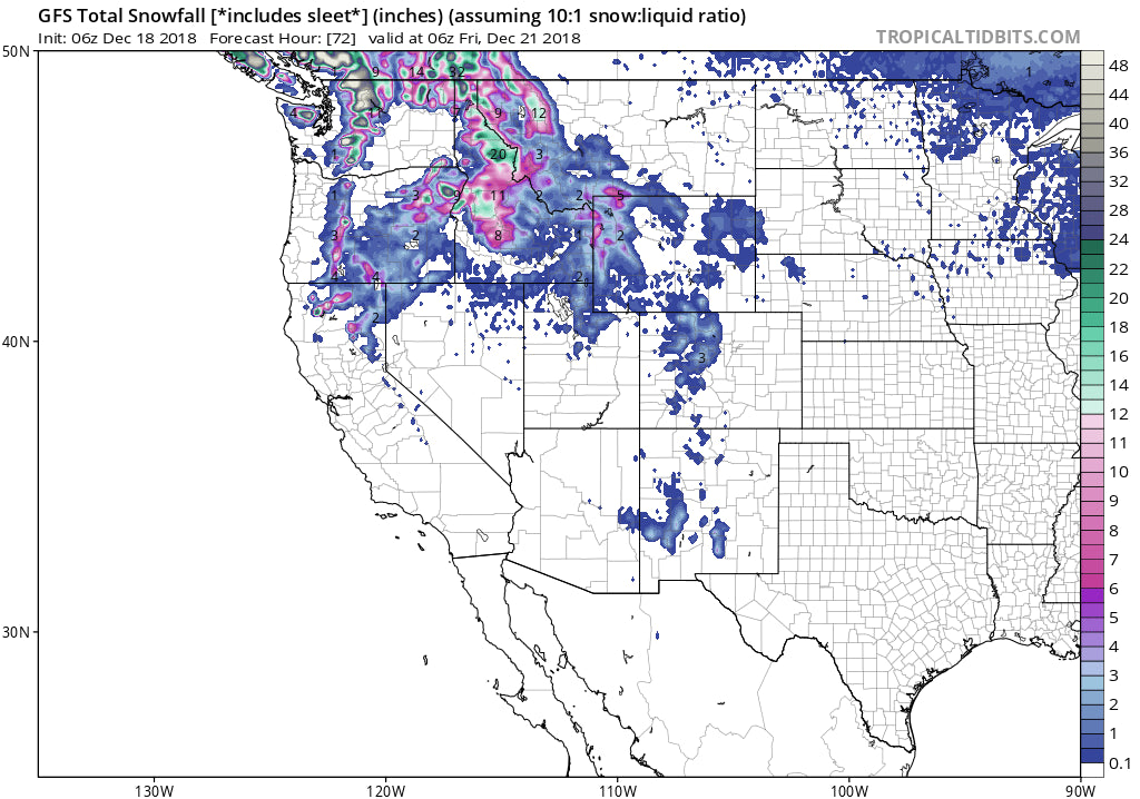
Below: You can see snowfall pushing in over the next 48 hours ending late Wednesday night. Heavy snow in the PWN moves east over Idaho and Wyoming before ending in Colorado by late Wednesday

EXTENDED FORECAST:
The parade of moisture from the NW on Thursday quickly moves over the northern Rockies Thursday night and Friday. It's going to take a similar track to the midweek storm. Light or moderate snow is likely for many areas of Idaho and Wyoming especially Friday morning. Leftovers tease Colorado and Utah.
The models bring a decent colder storm into the Northwest late this weekend. Its likely to split and move pieces of energy into the Rockies early next week (The Wasatch or Tetons may benefit). A stronger piece of energy in the split flow moves south over the Sierra early next week before pushing east over much of the central and southern Rockies. This energy should increase the chances of snowfall for much of 4 corners region pushing some snow into most of Utah and areas of Colorado by Xmas Day. It's still too far out for any confidence but the models have been reasonably consistent. You may consider a late weekend chase in the PNW or Northern Rockies and an early or midweek chase somewhere in the central or southern Rockies. Stay tuned to the chase forecast!
Powderchaser Steve


