SUMMARY:
On Tuesday morning the southern resorts in Colorado are waking up to storm totals of 15-24 inches favoring the southern San Juan Range (Silverton, Wolf Creek). Purgatory has 13 inches with Telluride at 8-9 Inches. I highlighted the SW winds would favor the resorts that picked up the most snow. Further north in Colorado, we mentioned resorts further west on I-70 would see the highest amounts. Aspen Highlands scored 11 inches Monday night with Steamboat in the 6-7 inch range. Further east towards Summit County, saw less snow with generally 4-5 inches at most locations. At least nearly every ski area in Colorado grabbed some powder. we feel good about the previous forecasts leading up to this storm.
In Utah southern areas scored big time with 16 inches being reported at Eagle Point and 11-12 at Brian Head.
Northern Utah snuck out the edge of the storm favoring Park City (South or SW winds) with 4 inches.
Below: Steamboat Powder on Tuesday morning.

The next storm to watch is a very potent storm for Whistler and the Cascades of Washington and Oregon. This will bring heavy snow to these regions on Wednesday along with strong winds from the SW. Snow levels are going to rise Wednesday and fall slightly on Thursday. The last chair Wednesday should see 9-15 inches at many resorts favoring the northern Cascades. Additional light to moderate snow will be likely for Thursday morning with slightly better temps. The bulk of this storm will fall on Wednesday, with many red flags that could put a stop on a chase (Wind, Temps). Last-minute decisions. The Sierra gets the leftovers (3-7) for Thursday morning. The Sierra will get very deep next week so keep reading.
The Rockies get light leftovers from this storm that has wrung out most of its moisture by the time it pushes east. The extended period looks very active for the Rockies.
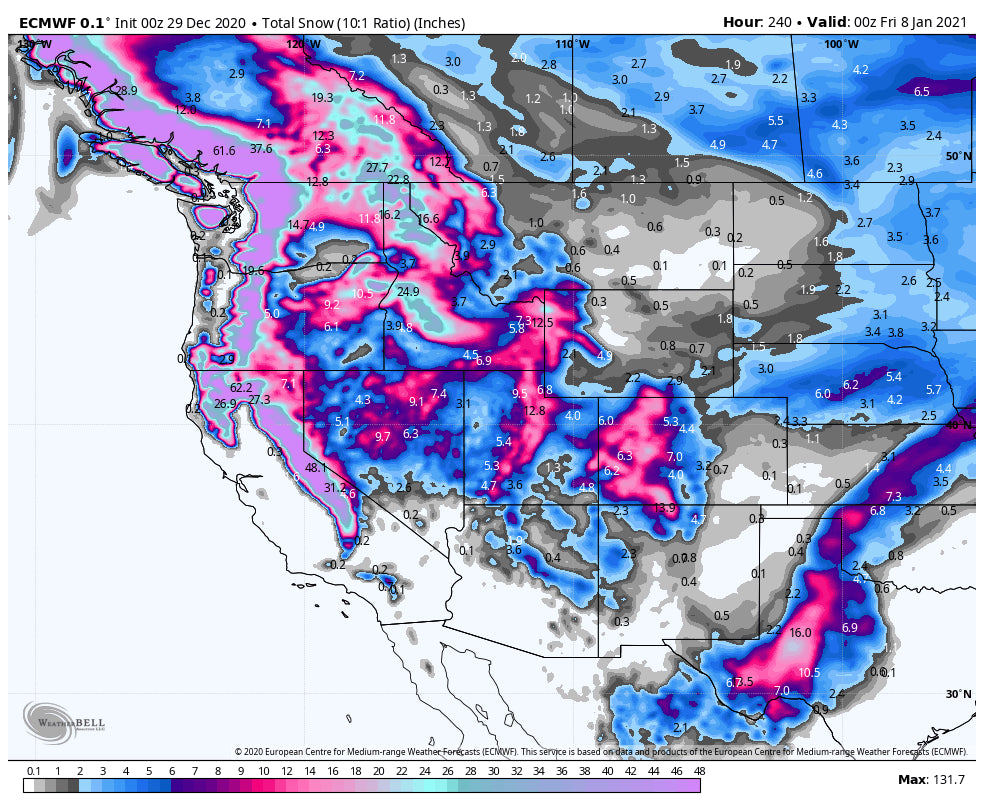
Additional energy will pound the Cascades and western Canada by the weekend. This system is fairly warm and very moist with another 1-2 feet likely for many areas. Colder air finally moves in for Sunday with additional snowfall for the Cascades. The panhandle of Idaho including Selkirk Powder will benefit from 1-2 feet of snowfall totals by Sunday morning above 3500 feet.
Extended:
That system will transition over the northern Rockies increasing the odds of a decent dump for the Tetons and Wasatch. Northern Colorado may also make the list. Currently, it appears to be a Sunday-Monday event.
The Jet Stream next week (January 5th and beyond) will finally slide south bringing a long period of storminess to the west. There are signals of an atmospheric river setting up over the Sierra. Significant snowfall may accompany this period as storms transition from the PNW, Sierra, and a good portion of the Rockies. It's possible that we see several 1-2 foot events in many areas next week! We are going to start 2021 with a bang! Many resorts in the west may be celebrating.
Announcement: Please support our sponsors. Tire Rack can provide you the winter wheel/tire packages that will allow you to get early chairs. Our newest sponsor Alaska Backcountry Guides will provide you the best experience if you simply want to get away from resorts this Spring. They have special offers if you mention Powderchasers.
Enjoy the powder everyone! Chase safely! Stay Healthy!
Powderchaser Steve


