Yesterday was opening day at Selkirk Powder in northern Idaho. They are open for the season (Cat Skiing, Snowmobile Guided tours currently). Heli won't be open until the end of January. There is snow in the forecast!
Our chase took us to the Tetons where over a foot of overnight pow fell at both Targhee and Jackson Hole. We combined this with a photo session in Grand Teton National Park where I was lucky to catch famous Bear 399 and her 4 cubs that are still out \"fattening up\". While she is not a fan of powder, she did feed on an elk carcass yesterday. Follow Instagram page @powderchasersteve
Conditions in the Tetons were epic, to say the least, but we won't go into details to spare your stomach from churning. Avalanche danger in the Tetons was rated HIGH for Sunday. The time is ripe to start focusing on resorts in Southern Colorado and Utah. The models are all in synch showing 12-20 inches for the southern San Juan range of Colorado and 9-15 inches for southern Utah. Snow is already falling in these areas. Storm ski in southern Utah or Colorado Monday followed by additional snow for Tuesday morning (Might be deep). The big question is how much snow will work north into Utah and Colorado. Chases for central or northern Colorado will come Tuesday.
Bottom Line: You are safe chasing to any resort in southern Utah or Colorado for Monday and Tuesday. Expect a nice refresh storm skiing Monday (4-7) and another 6-12 Monday night (Storm totals will be 10-20 inches with the highest amounts in southern Colorado). While Telluride is in the San Juan Range it is a wildcard with most models showing 4-9 inches (Prefers NW or N wind direction versus SW). They could also overperform with intense snow bands setting up in this range. I am less bullish but would not be surprised to see them perform a bit better late Monday night. Winds veer to the west late Monday night or early Tuesday increasing snowfall rates for Crested Butte as a solid contender for this storm (Already has a few inches at press time). Irwin Lodge might see higher amounts. Plan on some sneak up powder for resorts further north.
Below: Total Moisture (Liquid) for Colorado and NM through early Tuesday afternoon.

Snow will push north Monday night favoring areas on the west side of the Continental Divide. Widespread areas of Colorado will grab a solid refresh of 5-9 inches for some powder late Monday and early Tuesday. Areas further west towards Aspen, and even Steamboat (Snow slides up from the south into the Flat Tops and hunkers into Rabbit Ears Pass) may see higher amounts. Steamboat while well north of I-70 can often have a backdoor powder day (Moisture from SW). Further East, the odds of deeper amounts may come to Beaver Creek (Likes the west winds) or near Vail Pass Tuesday morning. My confidence in Summit County is slightly lower.
Forecasting these storms that push up from the south can be tricky for areas north of the front. Wind shifts will create good moisture for the central and northern areas but moisture is often weaning. This storm has some moisture that will continue into Tuesday evening with NW flow (Some new light powder for Wednesday morning) for the central and northern Mountains.
Extended:
A very moist system will move into the Cascades by December 30th with slightly warmer temps. That will be followed by a cold front that will bring decent snow totals with dense snow at lower elevations and medium density to upper areas. While it's not an epic cold storm, it will help in building up bases to some areas that still need additional snow especially in the southern Cascades of Washington. That system drops south into the Sierra Range for New Year's Eve. Moisture albeit weakening will also impact the Wasatch and Tetons with low confidence on any significant amounts.
Below: Low pressure over the PNW and Sierra just prior to or during New Year's Eve likely will drop south over the Sierra before moving east over the Rockies.

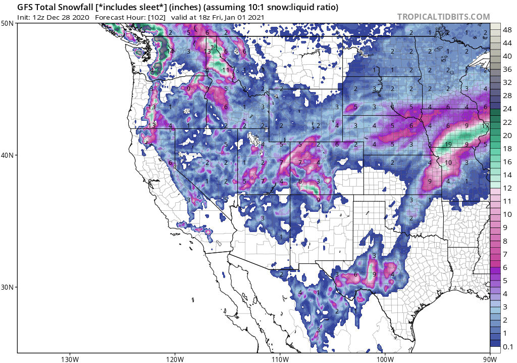
There is an additional storm with colder temps that moves into the Pacific Northwest that may start another active period for the PNW and better chances of snowfall to return to the Rockies. The period after New Years' is likely to produce some significant snowfall to many areas of the west with colder temps. This is likely to create some ideal chasing conditions. 2021 will be off to a good start!
Below: Deep Trough over much of the west in the 1st week of January. This may bring significant snow to many areas especially during the 1st week of January.

Check out Alaska Backcountry Guides Operation in Alaska who I personally endorse. Might be a great time to start thinking of small group Heli-Skiing while the Canada Border stays closed. This outfit brings a lot of experience offering small group Hel-Skiing and top-notch service. They still have open seats! They offer some specials for Powderchasers so be sure to mention us.
https://www.alaskabackcountryguides.com/?utm_source=Powderchasers
Enjoy the powder everyone! Chase safely and wisely! When chasing powder on the highway we always say it's better to arrive versus getting stuck in a snowbank. Better to get the 20th chair versus no chair. But then again, we almost never miss 1st chair. Stay safe!
Powderchaser Steve


