
Two waves of energy are passing over the Pacific Northwest today through Saturday. The primary influence of the heaviest snow totals is in the Cascades, Idaho, and northern Montana. By Saturday, the Tetons stand a decent chance of seeing the best leftovers with the Wasatch and Colorado wildcards.
New Powder as of 4 AM Friday (Telemetry- Unofficial) - Chase Now!
Baker: 16 inches
Timberline: 8 inches
Mt Hood Meadows: 7 inches
Crystal: 5 inches
Schweitzer: 9 inches
Brundage: 7 inches
Expected additional snow totals through Saturday
Baker: 7-12
Stevens Pass: 9-14
Alpental: 8-14
Crystal: 5-10
Mt Hood: 7-15
Timberline: 7-15
Selkirk Powder: 6-12
Schweitzer: 6-12
Whitefish: 5-11
Tetons: 7-14
Wasatch: 4-9
Steamboat: 6-11
Beaver Creek: 5-11
Crested Butte: 4-6
Winter Park: 5-10
Vail: 5-10
Breckenridge: 4-10
A-Basin: 4-8
Berthoud Pass: 6-10.
Forecast details Friday-Saturday.
Chases: The Pacific Northwest is active with new powder on Friday morning, and another wave is expected for Friday afternoon and into Saturday. The Good: Colder temps. Good timing for late PM Friday to early Saturday. The Bad: Breezy conditions are slightly warmer on Friday. There are no red flags for Friday PM/Saturday. Overall a good storm to chase. Additional snow totals will range from 8-14 inches, favoring the central Cascades of Washington and perhaps a few spots in northern Oregon.
Northern Idaho and northern Montana also fire Saturday with freshies from Selkirk Powder Guides, Schweitzer, Whitefish, and Lookout Pass—southern interior BC resorts (Whitewater, Red Mountain). These spots will likely grab 5-11 inches of freshies on Saturday for your first chairs. Temps will be cold, and quality will be high from late Friday to early Saturday.
Below: Additional snowfall from late AM or early PM Friday to early Saturday. The PNW is firing nicely, with another 7-15 inches likely at many WA and OR resorts. SW winds Friday favor the north Cascades of Washington with a wind shift to the W NW late Friday/Saturday (Convergence zones over I-90, Stevens Pass). The Northern Idaho areas are also firing. Oregon appears deepest from just north of Bachelor (Strong wildcard) to the borders with Washington (Deeper).

Below: Winds shift to the NW Friday evening, providing good cold air and an opportunity for many resorts to pick up decent totals (Baker was favored on the first wave with SW winds Friday). Wind speeds will also decrease for better quality Friday PM/Saturday.

Below: Cold air is settling into northern Idaho and Montana as snow falls Friday night. The map shows 4800 feet in C. Quality will be high.

Snow moves into the Rockies next for a few good chases.
Below: Cold air pushes south by Saturday, favoring the northern Rockies, including Montana and Wyoming. Utah and Colorado stay south of the coldest air, reducing snow ratios—map: 10K feet in C.

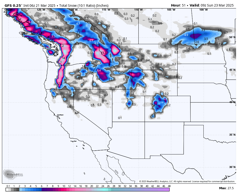
Below: American GFS shows decent totals over the Tetons and perhaps northern Colorado through Saturday morning. Utah is a wildcard with generally 4-9 inches in the Cottonwoods extending north from Ogden to Logan (Beaver). The pink areas in Wyoming are central to the northern Teton Range.

Bottom Line Rockies: Models do not agree with some short-term solutions showing higher totals for the Cottonwoods (My Forecast is from 5 to 10 with the HRR higher). Warmer temperatures in Utah might keep totals lower below 8,000 feet.
Tetons offer colder air with higher odds of better quality on Saturday. Colorado grabs moisture with SW flow and initially keeps temps warmer Friday night. Colder air and a wind shift to the west could favor Steamboat and Beaver Creek (Can sneak up surprises with the west flow). The models show decent odds near or north of I-70 into Grand County. Summit County is a wildcard. Vail could also perform well with an eventual WNW wind shift.
Below: Total snow through Saturday afternoon (Split from Friday late-night snow to midday Saturday). Models differ on totals, but there are good odds of a few spots in Colorado grabbing near 8-10 inches. Warmer temps might also provide a bit of a downside.

Below: U of U ensembles using the GFS and European models showing an average of around 8 inches for the summit of Park City Mountain.

Below: Stevens Pass Is looking healthy with the next storms that have already started Friday.

Below: Vail Pass falls in the 8-inch category for Saturday.

Below: Steamboat showing a bit more hope from late Friday to midday Saturday.

The Chase:
Friday- PNW (Baker is deepest), with other resorts filling in by midday. Snow increasing. Cold air incoming.
Saturday: PNW- Northern Idaho, Northern Montana, Southern Interior BC, Tetons. Wasatch Wildcards.
Saturday: Colorado wildcards- Northern mountains from Beaver Creek/Vail to Steamboat, Grand County. Summit County and Aspen wildcards.
EXTENDED POW
The period from Sunday to Wednesday will stay active in the PNW and areas of Canada. Unfortunately, warming is occurring, and snow levels will fluctuate from 4800 to 6,000 feet. There are a few cold spells in between, so hopefully, a few periods of the moisture below fall with colder temps, followed by warming.
Below: 24-hour snow totals from Sunday, March 23, to Wednesday, March 26th. The focus is in the northern PNW, BC, and even areas of Idaho and northern Montana. Peak periods are in the Sunday/Monday range.

Below: Temps at 4800 feet (C) are warming from late Sunday to midweek (March 25th). There are brief cooldowns followed by warming to 3-6C (4800 feet). This will push show levels well above 5500 feet in the interior of BC and as high as 8000 feet in the Cascades. Some rain will fall at resorts later this weekend or early next week.

Forecaster: Powderchaser Steve @powderchasersteve on Instagram
DONATE FOR POWDER!
NOTE: Please support Powderchasers with a donation, merchandise purchase(such as a hat or stickers), or sign up for our custom Concierge Powder Forecast Package, where we provide 1:1 phone & email support to get you to the deepest locations possible. When chasing snow, the Concierge gets you the very best intel. Sign up for our free email list so you never miss a powder day.
New Concierge Program Guarantee or the Chase is free!


