
1. SUMMARY
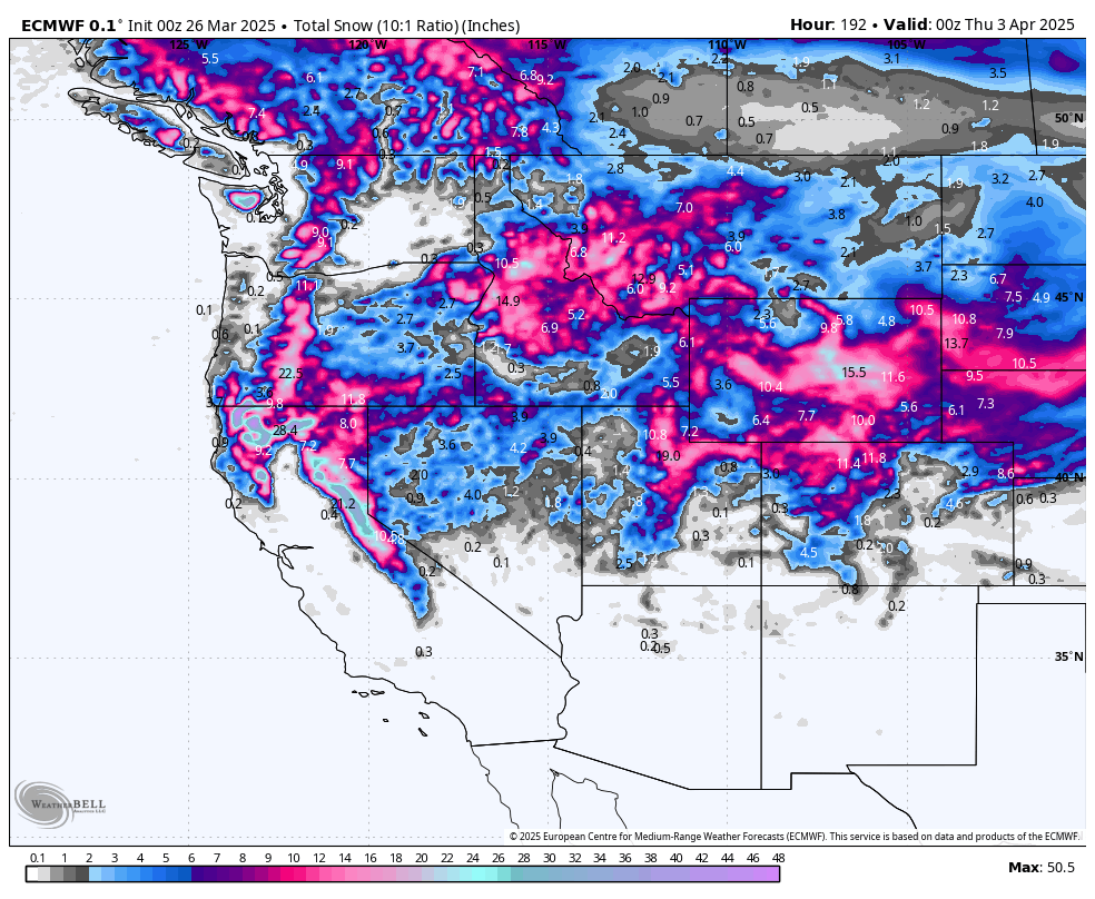
A parade of storms will hammer the Sierra Nevada with significant snowfall and respectable snow-liquid ratios, while most other western regions see only modest to moderate fresh snow. The bottom line? California’s about to go off, with the Sierra potentially eyeing over four feet of mostly high-quality powder by mid-next week. Elsewhere, look for more minor but still fun totals in Utah’s Cottonwoods and scattered refreshes across Colorado and the Northern Rockies.
DONATE FOR POWDER!
NOTE: Please support Powderchasers with a donation, merchandise purchase(such as a hat or stickers), or sign up for our custom Concierge Powder Forecast Package, where we provide 1:1 phone & email support to get you to the deepest locations possible. When chasing snow, the Concierge gets you the very best intel. Sign up for our free email list so you never miss a powder day.
New Concierge Program Guarantee or the Chase is free!
2. CHASE FORECAST
(All recommendations combine the prior night’s snowfall with the same-day snowfall to target the best window for deep turns.)
Friday (3/28)
-
Sierra: A quick shot of a few fresh inches might entice dawn-patrol laps at Palisades Tahoe, Kirkwood, and Sugar Bowl if you’re already in the area. But totals are modest (2–4" overnight), so don’t expect full-on blower conditions.
Saturday (3/29)
-
Light wrap-up snow in the northern Sierra. Most places won’t see enough to justify a full-on chase. Consider it a teaser day before the real onslaught begins Sunday night.
Sunday (3/30)
-
Sierra: Initial storm energy arrives. Sunday morning itself is only packing a few new inches at places like Kirkwood (1–2" overnight + daytime). It’s a small appetizer before the main course ramps up Sunday night.
Monday (3/31)
-
Sierra: Overnight (SunNight) plus Monday day could total around 2–4" at Kirkwood and Palisades, with similar amounts for Sugar Bowl. Still relatively modest, but the real dumps are just around the corner.
-
Utah: Light snow arrives in the northern Wasatch (e.g., Powder Mountain, Alta, Solitude), enough to refresh surfaces but not epic—look for 3–5" by Monday afternoon in the best spots.
Tuesday (4/1)
-
Sierra: Now we’re talking. Monday night plus Tuesday day should stack up 6–12" at Kirkwood, Palisades, Mammoth, and Sugar Bowl—and possibly a touch more if upslope bands line up. Snow-liquid ratios climb into the 10–12 range for many spots, meaning solid powder (not cement).
-
Utah: Storm momentum builds in the Cottonwoods and Ogden-area resorts. Tuesday morning chase could reveal 5–8" in places like Alta/Snowbird or Powder Mountain. Decent density (SLR ~10–12), so expect fun, surfy turns.
Wednesday (4/2)
-
Sierra: The biggest single-day slam. Some resorts (especially Kirkwood, Mammoth, and Sugar Bowl) could see an additional 10–20"+ (combining Tuesday night + Wednesday daytime). Snow ratios remain in that 9–12 ballpark—perfect for a deep, high-quality powder day. If you’re gunning for the deepest shot, Wednesday is the day to drop everything and go. Remember that next week's storm is still very far out; these totals can and WILL change before then. Get excited, but don't get your hopes up too much just yet... stay tuned for updated forecasts this week.
-
Utah: Another wave adds a fresh 4–8" overnight into Wednesday for the Wasatch, boosting totals toward a foot+ since the weekend. Not as huge as the Sierra, but it’s still a respectable midweek refresh.
-
Colorado & Northern Rockies: Light-to-moderate daily snows continue, with many CO resorts (e.g., Winter Park, Steamboat) picking up new dustings every night. Expect 3–6" for a midweek chase, favoring higher-elevation slopes with cooler temps (e.g., Loveland/A-Basin). Nothing massive, but enough to keep surfaces fresh.
Beyond Wednesday
-
The storms continue in California even into Wednesday night, meaning Thursday morning (4/3) could still be prime in the Sierra with an additional overnight dump. Everywhere else, the pattern stays generally unsettled with smaller daily accumulations.
3. KEY POINTS
-
Good:
-
Sierra Blitz: Multiple pulses with excellent totals (3–4+ feet in spots).
-
Snow Quality: Ratios in the 9–12 range for most of the biggest Sierra hits—solid powder, not the classic “Sierra cement.”
-
Utah & Colorado: Consistent refreshes keep surfaces from turning crusty; some pockets of 8–12" by midweek in the Wasatch, 6–14" across parts of CO.
-
-
Bad:
-
Wind! Sierra ridges could see 80–100 mph gusts, with strong winds spilling into valleys. Expect lift closures or slowdowns at times.
-
Snow Levels: They briefly start high in the Sierra (above 7,000–8,000 feet) on the leading edge of these storms before dropping. Early precipitation could fall wet and heavy at midmountain.
-
-
Wildcards:
-
Thunderstorms & Convection: Parts of the West (PNW, Sierra, Northern Rockies) may see embedded thunderstorms. Localized bursts could quickly boost totals or bring graupel/hail.
-
Model Variability: Some runs hint at slightly warmer or cooler air intrusions, so final snow levels might wobble a bit. Overall confidence is moderate-to-high.
-
4. REGION-BY-REGION DETAILS
California (Sierra Nevada)

Storm after storm marches in. Southwest flow cranks up the wind machine, especially near the crest. Initial precipitation starts high (snow levels ~8,000–9,000 ft) but drops to 5,000–6,000 ft Monday onward. Keep in mind next week's storm is still very far out; these totals can and WILL change before then. Get excited, but don't get your hopes up too much just yet... stay tuned for updated forecasts this week.
-
Big Winners:
-
Kirkwood: Could push 4+ feet between late Saturday night and Wednesday night, with Tuesday and Wednesday likely the deepest. Snow quality improves each day as colder air moves in.
-
Mammoth: Eyeing 2–3+ feet by Wednesday night, with steadily improving density each day. Winds will be fierce, so watch for possible upper-mountain closures.
-
Palisades & Sugar Bowl: Up to 30+ inches in that Sunday–Wednesday window. Expect heavier snow early, then fluffier accumulations mid-late storm.
-
Pacific Northwest

A showery pattern continues, but overall snowfall remains modest. Thursday–Friday sees some leftover showers and possible thunderstorms, but not much mountain snow. Another weak wave Sunday into midweek brings 4–10" across multiple days—enough for occasional fun laps, but no major “dump.”
-
Mt. Bachelor might see ~6–16" total by late Wednesday, highest near the summit with decent SLR (up to ~13).
-
Timberline/Crystal/Stevens/Baker: Generally lighter totals (4–10" across multi-day stretches). Watch for thunderstorms and gusty winds but no massive storms on the horizon.
Northern Rockies (ID/MT/WY)

Unsettled spring weather continues, but total accumulations are modest. Warm daytime temps could reduce snow quality below 6,000–7,000 ft.
-
Grand Targhee & Jackson Hole see small daily increments (5–12" total through Wednesday), with highest SLR near the tail end. Good enough for softer turns each morning, but not epic.
-
Idaho resorts (Brundage, Bogus Basin, Sun Valley): Periodic bursts add up to maybe 6–14" by midweek. Watch cooler nights for better morning conditions.
-
Montana (Big Sky, Bridger, etc.) picks up spotty 6–10" totals, with slightly higher amounts possible at Big Sky’s summit. Breezy conditions and partial sun may create variable surfaces.
Utah

Record warm temps pivot to unsettled weather Friday onward. By late weekend into early next week, a more organized system hits especially northern Utah.
-
Cottonwoods (Alta/Snowbird, Solitude/Brighton) can tally roughly 1–2 feet by Wednesday night if you stack all the smaller pulses, with the best single “bump” likely Monday night into Tuesday or Tuesday night into Wednesday. SLRs are mostly 10–13—relatively fluffy.
-
Powder Mountain and Beaver Mountain: The early-week storms had a similar story, with a total of around 8–17". They were not as big as the Sierra, but they are respectable.
-
Park City/Deer Valley: The totals are lower (5–10"), but it's still a decent reset.
-
Southern Utah (Eagle Point): Light accumulations arrive Monday night into midweek (up to ~9").
Colorado

A spring pattern with on-and-off snow into midweek. Totals are less dramatic than the Sierra, but many mountains will see daily freshies. The heaviest potential arrives Saturday night through Wednesday, but each resort’s distribution is hit-or-miss.
-
Winter Park/Steamboat: Possibly 8–15" total over multiple days. Warm afternoons might reduce the fluff factor.
-
Loveland/A-Basin: High SLR near 14–15 for some bursts—light, dry powder! Could net 8–15" by Wednesday.
-
Central and Southwest CO (Crested Butte, Monarch, Telluride): It is generally 5–12" by Wednesday. Dry powder is up high.
-
Vail/Beaver Creek: 6–13" range with excellent overnight preservation.
5. EXTENDED OUTLOOK
Another active pattern remains in early April, especially for California and parts of the Intermountain West. The Sierra could stay in storm mode with additional systems late next week, while the Rockies see continued smaller pulses. If you’re chasing the biggest late-season dumps, keep your eyes locked on the Sierra train—there’s no sign of it stopping anytime soon!
DONATE FOR POWDER!
NOTE: Please support Powderchasers with a donation, merchandise purchase(such as a hat or stickers), or sign up for our custom Concierge Powder Forecast Package, where we provide 1:1 phone & email support to get you to the deepest locations possible. When chasing snow, the Concierge gets you the very best intel. Sign up for our free email list so you never miss a powder day.
New Concierge Program Guarantee or the Chase is free!


