
Good morning everyone: This is Powderchaser Steve with your Tuesday Powder Forecast that will be deep in many areas of the west. If you want custom chase options, and the deepest snow (Where we chase) please join our Concierge program to support Powderchasers. Thanks to our sponsors (Please check them out) these forecast can continue.
There is a consistent stream of moisture entering Coastal BC this week that will drop south over the Pacific Northwest beginning late Tuesday night. We see 9-12 inches every 24 hours for Whistler, Mt Baker, Stevens Pass for both Wednesday and Thursday (1-2 feet) With SW winds it's possible that the northern Cascades out perform the Ski Areas further south (Alpental, Snowqualmie, and Crystal). The southern regions of the PNW will do slightly better in the late Wednesday to Thursday night period when the winds shift a bit more westerly (W SW), with moisture dropping south into Oregon. Mt Bachelor, Timberline Lodge, Mt Hood, and Crystal should all grab 9-14 inches during this period. Snow will continue in the central and northern Cascades albeit lighter intensity. Bottom Line: Chase north Wednesday and track moisture again for Thursday or Friday either north or south. Western BC, PNW, all deep with interior BC in the 9-14 inch range.
For those chasing to the Sierra light snow and warm temps will underway by midnight Tuesday into Wednesday. Snow levels are likely going to be around 7000 feet so upper mountains might ski best. The next storm system intensifies with plenty of moisture streaming off the Pacific for moderate to heavy snowfall Thursday and Friday. Unfortunately, the temps are still on the warm side so amounts may reach 3-4 feet at upper elevations and much lower amounts at the bases. There is another storm and much colder temps late this weekend. The sum totals in the Sierra will be very impressive by early next week. Consider higher elevation resorts for this storm initially or simply stay on upper mountain lifts. Bottom Line: Very moist storm, but fairly warm temps initially.
Below: Total snowfall for the Sierra is impressive through early Friday however warmer temps will keep amounts lower at the bases. 3-4 feet is possible above 7500 feet. Snow will continue at times this weekend.

Elsewhere in the west, we are keeping our eyes on northern Idaho (Selkirk Powder) for 12-15 inches in the Thursday/Friday timeframe. Snow may continue in north central Idaho for the weekend including the central Panhandle. With southerly winds at lower elevations, snow will funnel nicely up the valleys in the Sawtooths with 12-16 inches likely for Thursday/Friday. Temps will also be a bit warm, so higher elevations may ski best. Moderate snow will be found further west towards McCall. Decent snow totals are also noted on the models for northern Montana (Whitefish) especially Thursday and Friday (5-10 inches).

In Utah, Wyoming and Colorado, low pressure takes hold early Thursday to Friday with some highlights in the Tetons, Wasatch, and most of central and southern Colorado. The peak snowfall for the Tetons and Wasatch will be midday Thursday to Friday mid morning. Some light snow might preclude the front Wednesday. Steady snowfall will be the entree for Thursday, especially in the Tetons followed by the Wasatch mid morning. Snow will intensify Thursday night or Friday morning. The Tetons will likely see 9-14 inches at the upper elevations and 2-5 at lower elevations. The temps are warming on Thursday/Friday (SW flow), and don't really get cold until Saturday (Light snow continuing). Bottom Line: This storm could be great for upper elevations of the Tetons, but not a deal breaker for the lower mountain (Good base building snow, perhaps decent quality at the summits). Friday will see a slight cooling trend and some lower elevation snow.
Below: 10K temps in C, are still pretty warm in the Wasatch with a bit colder air working into the Tetons Friday morning.

In the Wasatch, the models are hinting at 12 inches for 1st chairs Friday (Big Cottonwood might over perform LCC), 4-9 in the upper elevations of Park City, 5-10 possible for the summit of Snowbasin (Does well with SW flow) and extending into southern Idaho. Snow will be heavy at times Friday morning so expect an additional 5-10 inches during the day at many locations. Temps are on the warm side, especially Thursday so lower elevations will see less, and quality may be lacking from a density standpoint at mid elevations. Winds are also a factor at times Thursday and Friday so expect some possible delays both days. Bottom Line: Deep snow Is likely especially Thursday PM to Friday PM. Temps are warm so quality may be lacking in some areas and winds could be gusty at the peaks. Not surprised to see 12-20 inch totals in some locations by late Friday in the Cottonwoods. Sundance may also over perform at the summit (Warmer temps).
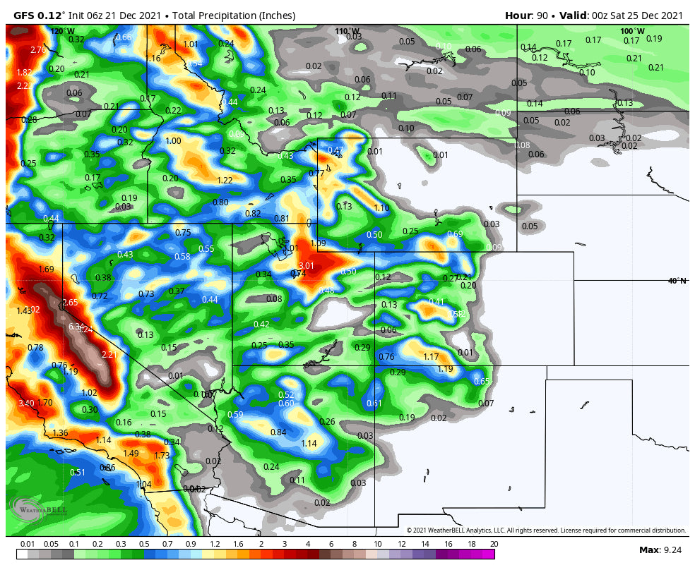
For Colorado and New Mexico (Yes, I just said NM), snow will be strongest late PM Thursday through late Friday evening. Currently models track the highest amounts from the San Juan Ranges up to the Gunnison Valley and further north towards Steamboat. Moderate snow will be likely along I-70 with the highest amounts possibly remaining on the western corridor. However, the European Model is showing some decent amounts east over Summit County Friday. It's possible with this pattern that Breckenridge and some other resorts further east come up with some decent amounts. And finally, we can talk about New Mexico as it's likely that Taos and other areas that have not seen much natural snow grab some freshies Friday/Saturday.
Below: The American GFS is bullish for Colorado for Steamboat, Southern mountains, and the Gunnison Valley, including Aspen. Less snow into Summit County.

Below: The European Model is more optimistic for a decent dump further east into Summit County. The 9.7 you see is Breckenridge in southern Summit

A quick look at the extended forecast shows much cooler conditions for the west and a continued pattern of moderate to heavy dumps for the PNW, Sierra, and eventually the Rockies late this weekend and extending into next week. We are eying a late weekend storm and another decent snow producer for midweek.
Please join our concierge for custom chases, more specific forecasts, and a chance to chase snow to the deepest resorts.
Stay Safe! The holiday period is looking pretty good from our books.
Powderchaser Steve - Follow on Instagram @powderchasersteve for adventure travel and photography.


