
This will be our final regular post for the 24/25 season. Thank You to all the followers, subscribers, sponsors, and those who love snow. The Powder Alert is from Wednesday night to Saturday for Montana, Utah, and Colorado areas.
How did our season end up thus far?
Below: Current snowpack YTD. You can see the PNW had slightly below normal totals, well above normal, in Oregon and areas of Western Idaho. Many regions of Montana and North Idaho are near normal. The Sierra played catch-up late with a near-normal season.
The Tetons are above normal, with the Wasatch range near normal. A wide area of Colorado was near normal, including the northern San Juan Range. As we had forecasted, with a La Nina season, the southern mountains of Colorado, New Mexico, and Arizona are well below normal. We might add credit to Wolf Creek, which started the season in November with some big storms (Not unusual). Taos even scored a few epic 20-inch-plus days this season.

Forecast Wednesday-Saturday
Expected Snow totals (Some of these ski areas are closed).
Red Lodge Mountain: 20 inches (Closed until April 18).
Big Sky: 8-10 inches
Whitefish: 2-4 inches
Targhee/JHMR: 2-4 inches
Alta: 5-12 inches (Lots of model discrepancies)
Steamboat: 6-10 inches
Winter Park: 5-10 inches
RMNP: 6-14 inches (Front Range Mountains north of Boulder)
Breckenridge: 6-12 inches
Vail: 4-10 inches
Loveland Ski Area: 6-12 inches
Aspen: 4-8 inches
Purgatory: 9-12 inches
Wolf Creek: 5-9 inches
Telluride: 8-13 inches
Overall timing and chase
Wednesday: Snow begins in northern Montana, primarily influencing the eastern ranges near Glacier National Park (Whitefish grabs lighter totals). Moderate totals are expected on the eastern flanks of these mountain ranges.
Wednesday night-Thursday morning: Heavy snow develops over south central Montana near Red Lodge Mountain (Reopens 4/18 likely with deep powder). Big Sky (Wildcard) likely grabs moderate totals (*wide range of model solutions from 5-14 inches). The Tetons are too far south and west, with only light snow likely on Thursday.
Thursday: Snow develops over the Wasatch. Models entirely disagree with the short-term NAM pumping out 12-15 inches. The Deterministic models have trended lower totals and a southerly track (South of the Wasatch Range) with 3-6 inches.
Friday: Snow is falling over the northern mountains of Colorado with lots of model uncertainty. The low is tracking over northern Colorado, with counterclockwise winds noted near Steamboat, possibly initially impacting areas north of I-70. Upslope NE winds are indicated on the Front Range, likely.
Friday/Saturday: Colorado grabs many wildcards with models differing on snow totals. Likely, The National Blended models show double digits for all Front Range mountains, including Loveland Pass, AB, and WP. Meanwhile, the trend of the American GFS is a southerly track from sothern Summit County (Breckenridge) to the San Juan Range. The European model brings heavy snow to the northern mountains (Steamboat), with less snow noted for Summit County. Heavy snow is also indicated on the European for the San Juan Ranges.
Below: Colorado. The European model on the left shows double digits north of I-70, especially Steamboat, with high totals, which is also likely for the entire San Juan range. The American GFS model on the right has less snow up north and higher totals from southern Summit County (A-Basin, Breckenridge) and the western San Juan Range (Purgatory, Red Mountain Pass, Telluride).

Below: The cold front in Colorado only impacts the eastern Divide (-10C at 10K), with -6C noted for Summit County (Medium to slightly denser snow quality). Meanwhile, areas from Aspen and south to the San Juan Range are in the -2C to -4C range at 10K. This will result in dense, surfy snow (which could be good based on the warm temps and snow conditions preceding this storm). While the models are bullish above snow totals, warmer temps might lower the scales, especially at the bases (Less snow). The cold air along the Divide could provide some upside (Better liquid-to-snow ratios).

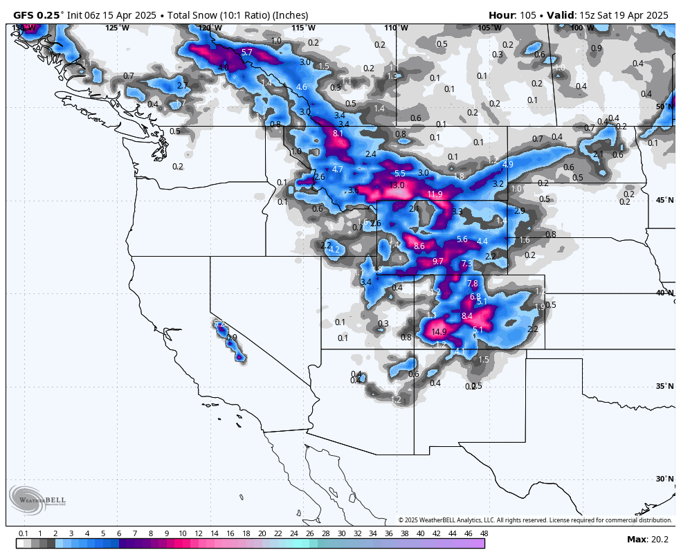
Below is the total snowfall per the American GFS model for the west through Saturday morning. Our confidence is highest for double digits for southern Montana (Red Lodge), with Big Sky wildcards. Utah likely underperforms; however, the short-term NAM is still cranking out big totals. (4-15 inch ranges). Colorado has high hopes of double digits, with lots of model uncertainty on totals. This might be a last-minute chase to Steamboat, Summit County, Grand County, or head to the warmer side of the storm in the San Juan Range. The Divide will be much colder and have higher quality.

Please donate for powder! Our forecast team often depends on this. We are the only powder-specific site that is still free. Donate Here
You can also purchase some cool swag at our updated store here.

Thanks again for your support in the 24/25 season. We will still post on the website this summer with occasional South America Powder Alerts. Our Powder Concierge program will remain active if you want to chase there. Our standard email list will terminate with this post until next season.
We would like to give special thanks to Tire Rack, Beaver Mountain, Ikon Pass, Selkirk Powder, Mountain Collective, Purl Wax, Indy Ski Pass, Alaska Backcountry Guides, and Unofficial Networks, which sponsored our site this season.
Forecaster: Powderchaser Steve @powderchasersteve on Instagram
Clay, Blake, Meredith, Paul, and Steve (Our full team).


