Short Term POW
The models show decent upslope flow (NE or Easterly winds) over New Mexico and southern Colorado, with the following and more substantial low dropping south into Mexico. The track has remained the same over the past few days. However, snow totals have decreased somewhat for some Colorado and northern New Mexico areas.
Below: Short-term HRR showing the highest totals on the eastern side of Wolf Creek Pass, Taos (Wildcard for 4-8 inches), and especially south of Taos County, perhaps closer to Ski Santa Fe (Closed). Summit County, Colorado, is on the northern cusp of any significant moisture.

Timing: Friday afternoon to Saturday morning (Good timing).
Bottom Line: Good late PM to early AM timing (Saturday morning pow), emphasizing New Mexico ski areas that do best with upslope Flow (Pajarito, Ski Santa Fe, Angel Fire). The moisture might fall too far south or east of Taos to grab double digits.
Here are our expected snow totals from Friday to Saturday.
Wolf Creek: 3-6 inches (Open).
Taos: 4-7 inches (Final weekend)
Angel Fire: 4-9 inches (Closed)
Ski Santa Fe: 7-10 inches (Closed).
Powderchasers picks for powder this weekend and next week.
Friday: Leftover Pow in northern Utah (Cottonwoods were deep Thursday). Colorado -Widespread 1-4 inches (6-7 at Powderhorn). Storm ski light snow in New Mexico on the last chair.
Saturday: Moderate snow for southern Colorado (Wolf Creek wildcard), Cuchara. There is moderate snow in northern New Mexico (Taos final weekend). Heavier snowfall further south or east over closed ski areas.
Monday-Wednesday- BC-coastal resorts favored above 3500. PNW Cascades (Washington Favored). Alyeska in Alaska (Unsettled all week with cooling Monday-Wednesday.
Extended POW (Next week)
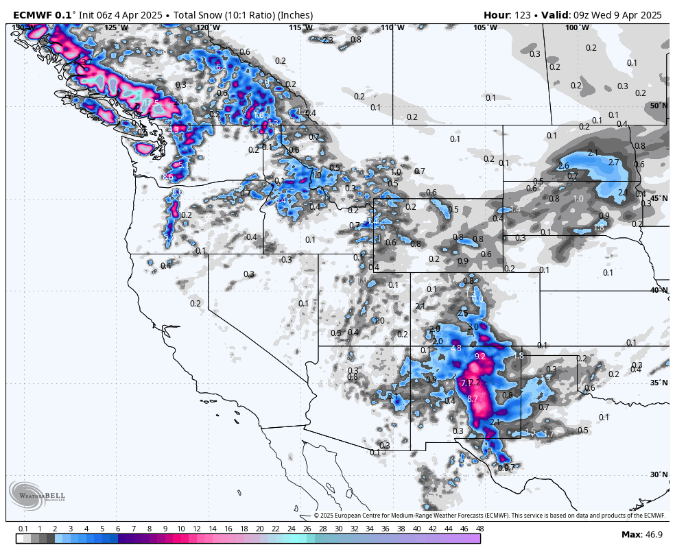
Below: Monday, April 7 to Thursday, April 10th. Low pressure is noted to focus on the BC coast, extending inland and south into the Cascades. This will be a relatively unsettled pattern until high pressure builds at the end of this loop by late Wednesday next week. The Rockies stay dry.

Below: Total snowfall for. The west over New Mexico and southern Colorado ends on Saturday, April 5th. The PNW and mainly coastal BC fires will occur early to mid next week. You can see decent totals near Whistler, with moderate totals extending into the Cascades and interior BC. Snow levels are respectable for this time of the year (3500). Whistler could land 10-20 inches above 3500 feet. Map: Total snowfall from Friday to Tuesday, April 8th.

Below: Alyeska will experience consistent moisture this weekend into mid-next week, with several light to moderate snow periods. This could add up to 10-20 inches at upper or mid-elevations by Wednesday.

Below: Snow levels at Alyeska will fall into respectable 500-foot ranges early next week (the Map is on Monday afternoon).

Support us with our newest store on Powderchasers here.

DONATE FOR POWDER to support us in our final posts for the season.
NOTE: Please support Powderchasers with a donation, merchandise purchase(such as a hat or stickers), or sign up for our custom Concierge Powder Forecast Package. If you sign up for the Concierge now, you can roll it into next season.
New Concierge Program Guarantee or the Chase is free!


