We are approaching the end of our frequent forecasts and encourage all of you to please donate on our website or purchase the swag. The donations help us more so if you have taken advantage of chasing powder, or living vicariously through Powderchasers please contribute here. We survive on your help from the powder community. Donate: https://powderchasers.com/pages/donate-to-powderchasers
Swag is available here https://powderchasers.com/collections/frontpage
Let's get on with the forecast.
The prime chase for Friday is at Mammoth where 19-25 inches of pure blower has fallen. Snow is continuing at Mammoth and the upper peak will remain closed (Snow showers all day decreasing by Friday evening). Snow showers albeit lighter will also continue for the Lake Tahoe resorts who grabbed lower totals. One model shows a deformation band setting up later Friday over the northern lake (Northstar) which could sneak out a surprise.
For the rest of the west aside form some light or moderate snow for northern Oregon and the southern areas of Washington (White Pass, Paradise) the Rockies grab a very sharp cold front plunging temps for the weekend.
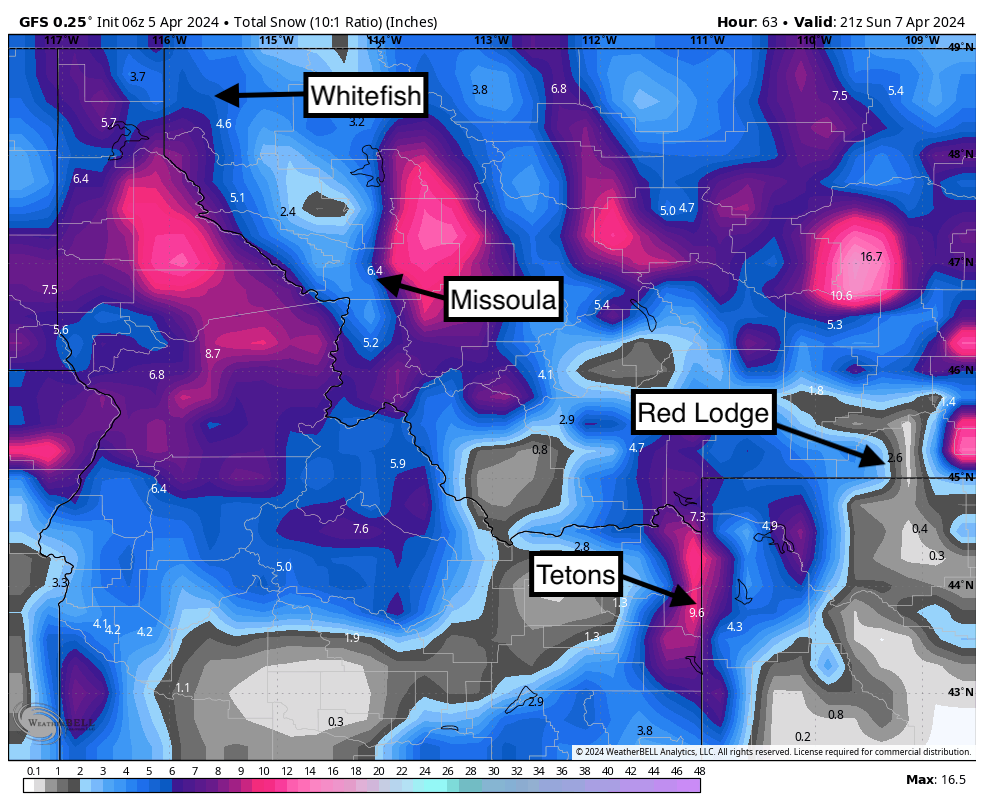
Below: Total snowfall through Sunday will be decent in some areas of Montana favoring areas east of Missoula , east of Red Lodge (Big Horns), with moderate totals for Whitefish, Bridger and Big Sky (5-10). Higher totals might land in the Tetons especially for Sunday morning.

There are several pieces to this storm with SW flow and very windy conditions bringing light to moderate snow for the Tetons and Wasatch range Friday. SW flow on Friday and early Saturday will favor JHMR before winds shift to the west (Teton Pass and JHMR) Saturday and NW Saturday night (Targhee delight).
We are not expecting more than 3-7 inches for the Tetons prior to Saturday early PM. NW flow and much colder air will crank some impressive snowfall totals for the Tetons Saturday night to Sunday (Targhee might come out ahead). Expect storm totals in these areas to be In the 12-15 inch range with a few isolated areas in the higher ranges. Very cold air will settle in creating very light density snow.
Meanwhile in the Wasatch scattered snow showers Friday (2-4) and Friday night (2-5) will turn heavier on Saturday as winds and a very potent cold front slams into Utah while the lifts are spinning. Friday will be very windy with upper mountain lift impacts. Saturday will see increasing snowfall and less wind.
Potent cold fronts can sometimes under or over perform. The models show around an inch of liquid for the Cottonwoods. This would bring 15-17 inch storm totals to LCC and slightly lower totals for BCC. Park City (Canyons side), Powder Mountain, can do well in this pattern. While the models are not impressive, the cold air orographic combined with lake effect snow Saturday brings decent confidence in this forecast for Utah.
We have also seen cold fronts with low moisture underperform also (We are gambling on orographic of cold air and NW winds aimed at the Cottonwoods and areas along or north of I-80). Keep an eye on Beaver Mountain for early Saturday where moisture will be falling earlier. Beaver might be a good starting point and then chase south for the PM. PCMR will also sneak out 5-10 inches Saturday.
Below: Snow totals slowly creep up on Friday at Alta and peak on Saturday between 1st and last chair (Last chair will be deepest). Snow showers might continue into Sunday morning albeit lighter intensity.

Colorado grabs snowfall Friday night to Saturday with generally 3-6 inches for most of the mountain ranges. This storm seems vertically stacked where snow will fall from Wolf Creek to Steamboat (North and south). Western areas might fare a bit better than the core of I-70 (Aspen, Steamboat, CB, Silverton) with SW flow initially.
SW flow in Colorado goes westerly by early Saturday which provides a better chance of snow spilling further east (Beaver Creek likes westerly winds) and into the I-70 core.
Heavier snow will fall over the I-70 corridor Saturday night when the winds shift to the NW favoring the core of Eagle County (Vail Pass) Route County (Steamboat), and Pitkin (Highlands) and even Telluride in the south. This flow can sometimes fare well for Monarch and Breckenridge also. We think higher totals will be found just west of the Divide and extend to Aspen or Powderhorn. Sunday will likely be the best day to ride semi deep powder (5-10). Some areas from Steamboat to Highlands might report higher totals.
Heads Up: Severe winds are noted in the models for western Colorado Friday and the Front Range late Friday night to early Saturday. These wind speeds are going to be dangerously high in the Front Range Friday night.
We might be chasing the eclipse on Monday to Vermont. Please send us a message if you are headed that way. Ride into darkness!
Heli Skiing: There are 2 open seats left at our Alaska Backcountry Guides (Our preferred provider) for April 14-20. Grab them now before they sell out. AK is having an epic season. Mention Powderchasers and receive a free concierge package and swag for next season.
Thanks for your support in keeping free forecasts alive at Powderchasers.
HELP US OUT! Please donate here to Powderchasers if you have taken advantage of our free forecasts. This is our number one source of revenue. Free swag for you on all donations from $50 and up. $100 donations grab you a custom shirt also!
We have new Powderchasers shirts fresh off production for sale currently for just $32 (Front and back powder)


