SUMMARY POW
A strong trough will track over the Sierra on Thursday bringing 12-18 inches to many ski areas by Friday morning. Snow continues in the Cascades and coastal BC through Saturday. The northern panhandle of Idaho is in scoring position as well as Colorado, Utah, Wyoming, Central Idaho, and New Mexico on the short term forecast. Hello New England! After 50-60 temps in some areas, some moderate snowfall is likely on Thursday.
FORECAST POW
Tuesday saw heavy snowfall continuing in the early AM hours for the Tetons before tracking south over Utah early in the afternoon. This brought rapid accumulations for many areas (10 inches for Brighton, 7- Solitude, 4-, Deer Valley-4 Park City, 8-Cherry Creek). My forecast was generally 4-7 inches which were on target with the updated forecast issued yesterday. This system hovered over the Idaho/Utah border all morning Tuesday crushing Beaver Mountain who reported 18 inches Tuesday morning with another 10 inches of storm skiing (28-30 inches in 48 hours).
Below: Beaver Mountain got fully crushed in northern Utah Monday/Tuesday with 30 inches of powder! Family run, affordable tickets, and fun terrain!

The short term chase should include deep storm skiing in the Sierra Thursday (12-18 inches) with some lift closures at the upper elevations (Strong winds and high precipitation rates). Friday might be epic as new terrain opens at many resorts that kept some areas closed on Thursday. Caveat: Most of the new snow will fall during the day Thursday so don't overlook the storm skiing opportunity (Only closures will be high wind impacted lifts and the summit of Mammoth-Low Vis).
Below: The Sierra gets a good dose of snowfall primarily 5 AM Thursday through the evening

In the Cascades, the models are skirting the highest snowfall south towards the Oregon border in the next 24 hours (Perhaps White Pass), Oregon Cascades (Timberline). Amounts will be less in the central Cascade range (Stevens Pass) while further north towards Baker could see 7-12 inches through Thursday morning. BC is in a scoring position for heavy snowfall over Vancouver Island (Mount Washington) with light to moderate amounts for Whistler into Thursday (2-5). Mount Washington would be a good novelty chase for Thursday.
Much of the leftovers from the Cascades filter into the northern Panhandle of Idaho Thursday/Friday with Schweitzer grabbing a moderate storm ski day followed by a refresh (5-11 inches).
EXTENDED POW:
A fast-moving but energetic cold front will bring a quick burst of snowfall for the Tetons, Wasatch, and most of Colorado on Friday (San Juan range is favored). The models show peak precipitation rates to be short-lived Friday morning with enough energy and cold air to bring 2-3 inch per hour snowfall rates to the Tetons and Wasatch Friday morning. My current thoughts are 5-10 inches for the Tetons and the Wasatch Range by midday Friday. The Cottonwoods are likely to edge higher and certainly on the upside of this range. Some moisture will push north into Big Sky (4-6 inches). The highest amounts may fall in a short 4-6 hour window of heavy precipitation especially over the Cottonwoods early Friday morning.
In Colorado, 7-10 inches are likely to await your first turns in the San Juan Range Friday with snow continuing during the day (Storm totals will be higher). Taos will also grab a decent storm for storm skiing Friday and leftovers Saturday. Further north along the I-70 corridor snow will be falling Friday albeit lighter than the southern zones (4-8). Friday could offer some decent storm skiing along the I-70 corridor favored by westerly flow (Beaver Creek could be in the hunt). Winds initially SW switching to the west Friday may also kick in decent amounts of Crested Butte and the Aspen area mountains. These amounts will be fine-tuned in a later post. Bottom Line: Quick moving system Friday favors the San Juan Range with a good chance of some decent amounts further north in the Central or Northern Mountains favoring I-70 or south.
Below: Total snowfall for Colorado and New Mexico through Friday night. I-70 resorts will see moderate snowfall Friday (4-8) with deeper amounts further south (Crested Butte might surprise). Purgatory, Wolf and perhaps Telluride (Wildcard) will score higher amounts.

Another system will enter the Pacific Northwest early this weekend favoring the northern Cascade Ranges and southern BC. Whistler is likely to be in a scoring position with some moderate amounts. A slow warming trend will rise snow levels in the PNW to 3500 feet.
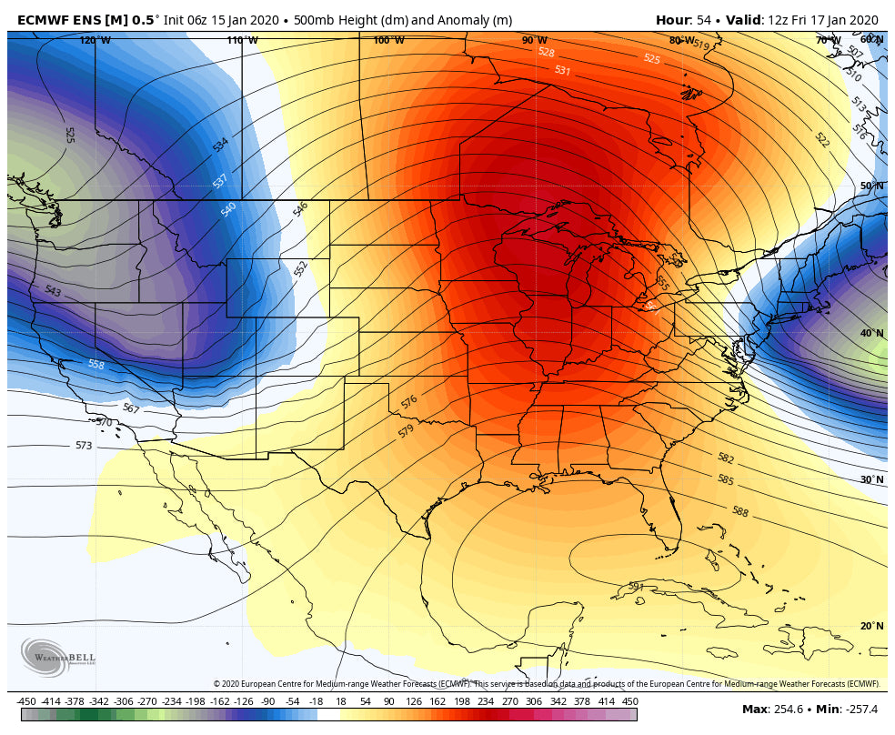
High pressure takes hold beyond the departing PNW system for much of the West early next week. The models show that ridge breaking down mid next week with a good chance of some additional storminess albeit weaker than the ones we have seen in the last 7 days.
Below: High Pressure takes hold late this weekend or early next week in the West.

Below: High pressure is breaking down by mid next week but it's unclear if any significant systems will occur.

Enjoy the powder everyone! Powderchaser Steve


