There are so many options in the next 48 hours. The deepest snow will fall in the Sierra in the next 24 hours. That system is coming in slower on the models peaking late AM Thursday over I-80 and continuing south throughout the day. You can storm ski Thursday afternoon and reap deep rewards Friday morning with terrain openings. Winds will be strong Thursday so my confidence in scoring deep (Storm totals in the 12-18 range) terrain where lifts did not spin until Friday is high. Mammoth will most likely open the summit on Friday. Aim for resorts with lower elevation on Thursday to avoid wind impacts on lift operations. Ski upper elevations on Friday.
In the Rockies, the action focuses on the Tetons, Wasatch, Southern Colorado, and northern New Mexico. Today's model runs are similar to yesterday, perhaps slightly slower in timing with snow breaking out around daybreak in the Tetons (Storm ski 6-8 inches during the day). For the Wasatch, the action will begin a bit earlier with heavy snow falling by 6 AM in many mountain locations. This is a quick-moving but vigorous cold front so PI (Precip intensity) will be very high. Heavy snow will quickly accumulate along the Wasatch Range by mid-morning before slowly decreasing in the afternoon (4-8 Park City, 7-10- Northern Wasatch Range, 8-12-Central Wasatch).
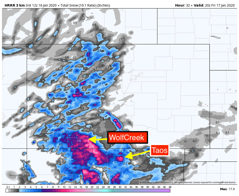
Models are not in good synch for Colorado. It's not often that so much discrepancy exists this close to an event. The general trend is to take moisture further south initially for Friday morning. Taos was a wildcard originally and now a solid contender for Friday. An initial surge of moisture will impact primarily New Mexico on Friday night (Separate piece of energy). The main energy from California impacts Colorado Friday morning. Moisture will be heavy in southern Colorado extending north to Wolf Creek Pass. Moisture will be significantly lower north of the Ski Area. The HRR short term 3KM model (Pretty reliable in the short term range) shows 12 inches on the top of Wolf Creek Pass by 10 AM Friday. The HRR shows slightly lower amounts for Taos (6-10). Meanwhile, the NAM is pushing snow totals further south with 12 inches plus for Taos Friday morning and slightly less at Wolf Creek. Bottom Line: High confidence for both Wolf Creek and Taos for Friday morning with an outside chance that Taos outperforms the Wolf (Initial energy over NM late Thursday will help Taos). Snow will break out around daybreak for the northern and central mountains of Colorado. Currently, the I-70 corridor should grab 3-7 inches by mid-afternoon with another 2-3 inches continuing into Friday night. Higher amounts might be possible near Aspen or spots further west on the I-70 corridor (Crested Butte is also somewhart favored).
Below: Short Term High Res HRR models for early Friday morning.

Below: The NAM is less bullish for Wolf Creek comparing to the above map and very bullish for New Mexico. Usually, the NAM 3KM is overdone so amounts may be more in line with the HRR above. The bottom line is that its possible moisture pushes further south with some discrepancies.

Other chases to consider are the Pacific Northwest this weekend. Warming temps and increasing snowfall will bring a foot or more to the northern Cascades near Mount Baker for Saturday morning (Denser than the previous storms). 5-10 inches are likely for the southern Cascades of Washington (Crystal) Whistler will also see continuous light to moderate snow in the next few days with a peak on Saturday. Temps warm slowly on Saturday (3500-4000 Feet by PM). Temps are slightly cooler in the north Cascades and Canada so that might be a better choice.
A significant storm is possible for the Sierra once again by mid next week.
Powderchaser Steve


