
Synopsis
The next several days will bring significant moisture to the west. Warm air has overspread most regions on Saturday morning, with rain falling below 8,000 feet in the Sierra. The PNW and BC are also in a warmish pattern with 4K foot snow levels expected for the next storm that is beginning today (Saturday). The general trend for all areas of the Sierra, PNW, and Rockies is for cooler temperatures to move in later Saturday into Sunday (Far west) and into the core of the Rockies by Sunday night and Monday. While cooler air flows into the west, at no time will we see blower, but in some areas, medium-density 10:1 or 13:1 snow is possible. Much colder air and a possible blower alert will be issued by mid next week.
Sponsor Announcement: No Lift Lines-Pure Heli $2K Discount!!
A rare $2,000 discount is being offered for Heli Skiing in Alaska for a recently cancelled guest with Alaska Backcountry Guides. This $2,000 credit is a great deal. Dates are below. This will fill up fast!
Any bookings will also receive a free PowderChasers concierge package good for 2 years!
Forecast
We are looking to chase this storm, but struggling with temperatures, snow density, and perhaps some wind in the Sierra Range. The PNW and western BC grab decent water totals; however, snow levels are once again at that 4,000 or slightly higher range. We can't believe that Whistler still has had few storms down low. Even the interior BC mountains are on the warmish side through the weekend. Moisture comes in waves with warm dense snow/rain for CA Saturday morning, turning colder by later Saturday to Sunday (Lake Level). In the Rockies, a similar situation exists with warm moist systems to tease areas Saturday PM/Sunday with SW flow (7500 to 8K snow levels). Colder air moves in Sunday PM to Monday (North to south).
Below: Total snowfall above 8,000 feet for California through Saturday evening (1st wave- warm). The southern areas of the lake are slightly favored here. Mammoth might benefit from a higher base elevation (no rain).

Below: 6-hour snow increments from Saturday evening to Monday morning (Day/Date in upper right). These 6-hour increments in pink represent 2-3 inches per hour snowfall intensities. There appears to be a brief break Saturday evening prior to some colder air that moves in Sunday. Storm skiing is peaking from Sunday morning to Monday morning from north to south. You could storm ski up north early Sunday and chase this wave south towards Mammoth that seems to continue into Monday morning. I like these 6-hour snowfall maps showing intensities and timing.

Below: 10K foot temps are warm (-3-4 °C) Saturday (Start of the loop) before some cooler air due Saturday night into Sunday (-6 to -7C at 10K). Notice that Mammoth further south stays warmer (-3C), but elevation gains will make up for it. I am a bit concerned on snow to snow-to-liquid ratios in the southern Sierra that might limit the 3-4 foot totals to mid or upper slopes.

Below: University of Utah ensembles averaging out snow totals for the upper elevations of Palisades around 40 inches. There is still some model discrepancy, as several lines still exist below and above the mean (Solid lines of the ensembles). We believe amounts will be variable on Saturday (Warm) but more consistent to the bases by Saturday night or Sunday morning. We feel confident with 25-35 inches.

Rest of the west
Below: This map shows total snow from Saturday through early Wednesday (1/7). The western BC mountain ranges score 2 feet early in this loop (Saturday/Sunday), while PNW, Idaho, and the north central Rockies peak in the Sunday to Monday timeframe. Snow levels are the spoiler for many areas below 4K in the Northwest (Rain/snow), including BC. Even the Tetons see rain or wet snow below 7K initially this weekend, before the cold front Sunday/Monday.

Below: Warm air this weekend is replaced by this initial cold front Sunday (PNW), slightly lowering snow levels as moisture is weaning (Some cold pow Sunday morning for the Cascades and BC atop the warmer dense snow). The cold front keeps a northerly track over the Rockies (Tetons are colder than the Utah ranges) Sunday night into Monday. Monday might be the best time to chase powder with the colder air in the Tetons (Sunday PM) and to some extent Utah (Monday). Idaho (Sun Valley and Brundage) and Montana also stay in the cold sector Sunday PM to Monday morning.

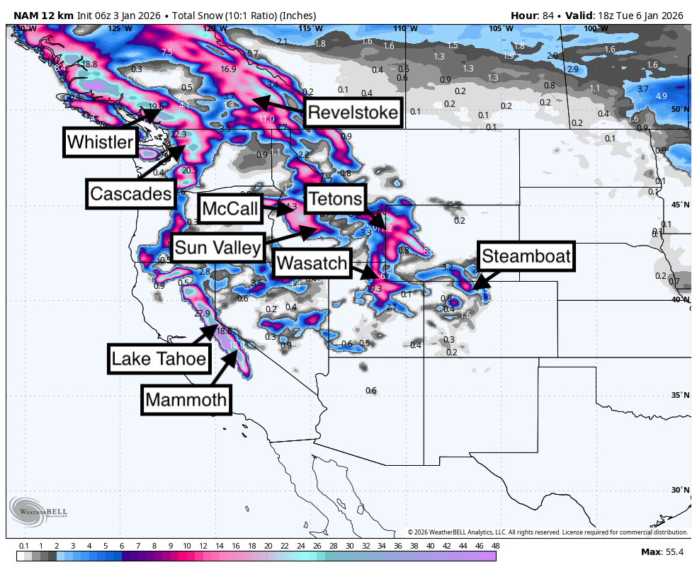
Below: Your best odds of double digits exist in the areas below (Total snow through Tuesday morning).

Forecaster Notes: Snow levels are going to keep the PNW and Canada on the high side. The Sierra is very warm Saturday, cooling into Sunday (Lake level). Snow density will be dense at lower elevations and medium dense even above 8,000 feet.
The Tetons have cooler temps than the Wasatch; however, still on the warm side with snow levels near 6500 until Sunday PM to Monday. Idaho is in a similar situation.
Model data for the Tetons/Versus Wasatch is unclear. Some models keep higher snow totals in Wyoming and less for Utah. Others are completely the opposite (Models are not agreeing). SW flow over Utah might keep higher totals under the warmer air Sunday in the northern Wasatch (Snowbasin or Beaver) and perhaps even Park City summits. Higher moisture streaming under SW is also better for BCC vs LCC sometimes. Snow levels are high Sunday (Rain below 7500). We need to get better model guidance.
Monday should be your best day to chase powder in the Tetons and Wasatch with cooler temps. Model data shows better overnight snow for the Tetons vs. storm skiing in the Wasatch. The Cottonwoods will see the highest totals due to the elevation on Monday, with peak snowfall in the morning through Monday PM.
Below: University of Utah graph showing the American GFS for Alta on storm #1 peaking Sunday night into Monday mid-morning (20 inches). The next storm moves in with colder air by Wednesday night (Less confidence here on snow totals).

Below: Park City ensembles at upper elevations also show healthy snow totals with both storms (Sunday-Monday and midweek). SSW flow on the initial storm this weekend into Monday can often sneak up better totals for Park City, DV, and areas north to Snowbasin. BCC can also overperform with SW flow. We feel confident with 10-14 on storm #1 and perhaps similar totals with storm #2 (Colder).

Below: Ensembles for Jackson Hole are consistent with around 18 inches through Monday midday and peaking again near January 8th. Lower totals will be evident below 7500 feet! Targhee might see higher amounts (SW flow and higher base elevation). Warm to Cold pattern.
 Chases:
Saturday: Warm dense snow at upper elevations of the northern Sierra. mid elevations near Mammoth (Bring a raincoat). Whistler's upper elevations will be getting deeper. Interior BC-moderate amounts.
Sunday: Cooler temps for the Sierra and decent snow totals. South lake might be deeper? Mammoth benefits from elevation gains, but temperatures might be a bit warmer than the north. It won't be blower.
Sunday PM: Idaho (Central areas near McCall, and perhaps Sun Valley). Tetons are doing better by the last chair. BC continues to fire with cooler temps (Whistler and interior areas). Wasatch is increasing slowly.
Monday: Wasatch or Tetons (Models not in agreement). Cottonwoods might be the deepest. Snowing during the day, with perhaps terrain closures dependent on snow intensities. Look for some surprise upsides north of I-80 or even the Park City Summits with SW flow.
Bottom Line: No ideal chase due to temps, but the Sierra will grab respectable 2-3 foot or higher snow totals at upper or mid elevations Saturday-Sunday. PNW is warm and not ideal until the latter part of the storm on Sunday. BC might deliver big numbers near Whistler, mid to summits. Idaho is cooler and could be a safe bet for Sunday chasing over to the Tetons or Utah later Sunday to Monday. Colorado is a wildcard for the northern mountains, favoring the western areas again (Let's hope this changes).
Extended
Cold air finally makes its way into the west, pushing some of the lowest snow levels we have seen for the season. Moisture will move into the PNW and Canada by mid next week and push south over a wide area of the west. The low-pressure system might be a fast mover; however, with great snow ratios, we could see double digits in many locations by mid to late week (Blower) espeically in the Cascades.
Below: -15C at 10K feet with a strong cold front due mid to later next week. This will cover a wide area of the west, perhaps pushing just east of the Sierra.

Below: 24-hour moving snow map from Tuesday morning (1/6) to Friday morning (1/9). This should land some good snowfall totals in the PNW, including Oregon, and cover a wide area of the Rockies extending to the Four Corners by late next week.

Please help us out if you read our free forecasts by considering some of our high-quality merchandise in our powderchaser store. or Concierge.
HELP US OUT- Please support your love of powder and our free forecasts with a donation here, or join our concierge program. We have merch on the website.
We appreciate the support.
Forecaster: Powderchaser Steve @powderchasersteve (Insta).


