
Summary:
_______________________
The West will continue to see widespread snowfall this week as a strong atmospheric river targets California, bringing up to an additional 20 inches through Monday across the Sierra, with snow-to-liquid ratios near 13:1. Although the storm began warm, snow levels are dropping, and Tahoe and Mammoth are expected to remain rain-free starting tonight; resorts around Tahoe, including Sugar Bowl, have already reported 25 inches in the past 24 hours, with totals likely to double by Monday afternoon. The Pacific Northwest will see a colder storm arrive on Tuesday, producing 2–3 feet of snow by Thursday, with snow ratios around 15:1 in Washington and 12:1 in Oregon, and the heaviest snowfall will be on Wednesday night. The Northern Rockies will remain active, with parts of Idaho, Montana, and Wyoming picking up up to 20 inches by Wednesday afternoon as snow ratios improve from roughly 11:1 to 15:1. At the same time, Alta, Utah is expected to be hit Sunday night through Monday with 12–18 inches, snow levels below base areas, and snow ratios near 12:1. Looking ahead, additional storms are lined up for later this week.
Recorded Snow Totals as of Sunday night (Still snowing in Tahoe). Totals are not in yet for many resorts on Monday morning, as these numbers will likely be higher.
__________________________________________
Mammoth: 30-40 inches
Palisades Tahoe: 20-35 inches
Heavenly: 24-35 inches
June Mountain: 20-30 inches
Sierra-Tahoe: 10-20 Inches
Northstar: 10-25 inches
Soda Springs: 22”
Boreal: 22”
Sugar Bowl: 25”
Kirkwood: 14-28 inches
Expected Snow Totals Sunday night - Thursday morning:
____________________________________________
California:
Mammoth: 7-9
Palisades Tahoe: 4-8”
Sugar Bowl: 6-9
Kirkwood: 4-8
PNW:
Mt. Baker Ski Area: 2-4 feet
Timberline: 2-3 feet
Crystal: 1-2 feet
Stevens Pass: 2-4 feet
Snoqualmie: 2-3 feet
Utah:
Alta/Bird: 16-24”
Solitude/Brighton: 12-18”
PC/DV: 8-12”
Snowbasin: 10-14”
Northern Rockies:
Tetons: 14-20”
Bridger: 2-4”
Big sky: 3-6”
Sun Valley: 2-4”
Colorado:
Vail: 4-8”
Breck: 3-6”
A-Basin: 2-5”
Winter Park: 4-8”
Steamboat: 8-14”
Aspen: 4-8”
Silverton: 2-6”
Canada:
Whistler: 14-20”
Fernie: 8-14”
Revy: 15-20”
Kicking Horse: 4-8”
Sunshine/Bnaff: 3-6”
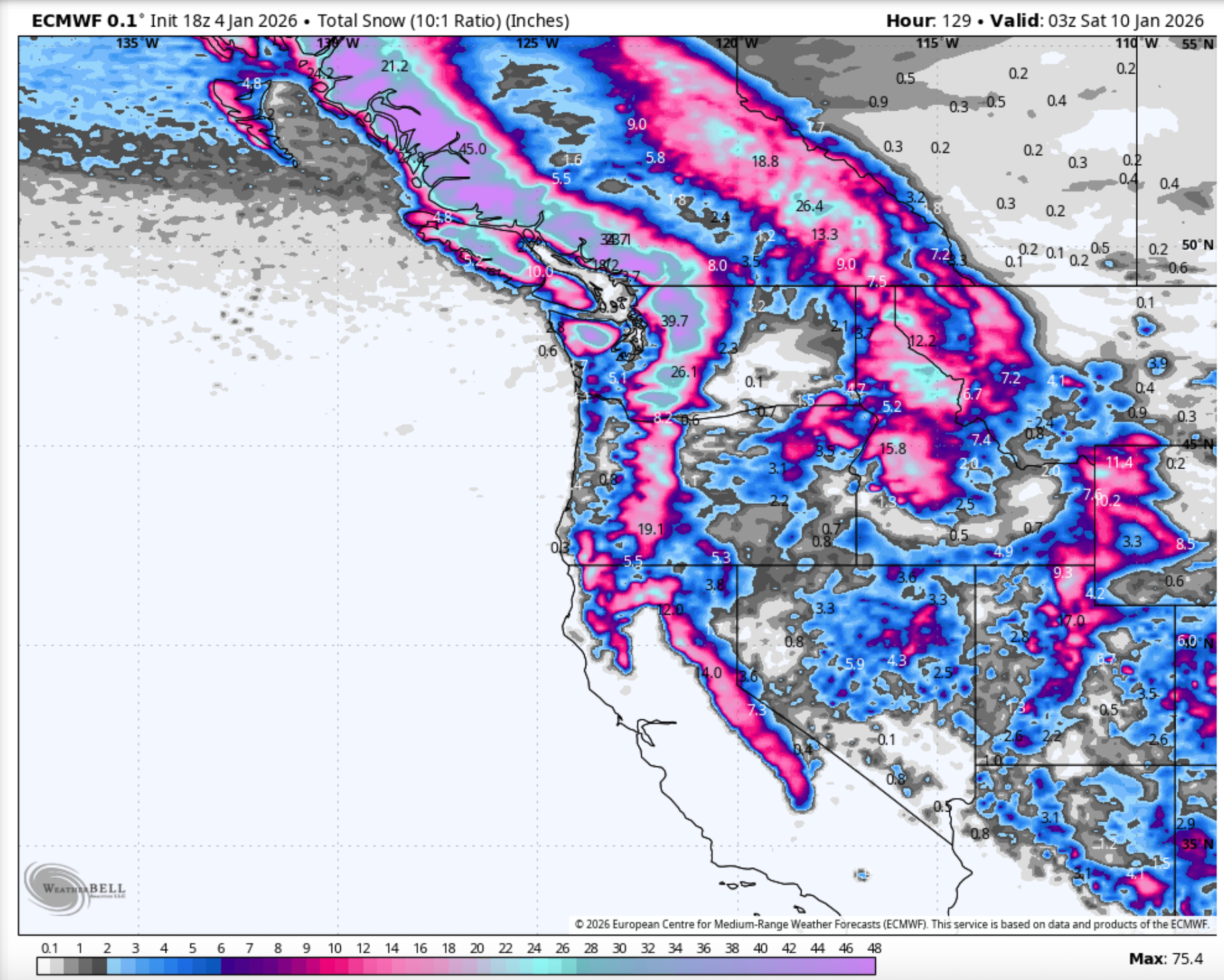
Below: Snow Map through Thursday morning showing Snow totals across the West. PNW and California score with 2-4 feet.
Utah:
_________________
Utah will finally see a significant storm Sunday night through Monday, with widespread totals of 12–18 inches by the end of the day Monday. This will be primarily an all-snow event, with medium-density snow and ratios near 12:1. Little Cottonwood Canyon is favored with 18”. At the same time, Brighton and Solitude should each pick up around a foot. Snowbasin may start as rain before quickly changing to snow, with totals near 10 inches for the Sunday–Monday period. Park City and Deer Valley could also begin warm with some mixing or rain, but should finish with a solid 8–10 inches. A smaller but colder follow-up system from Tuesday into Wednesday could add another 4–8 inches at AltaBird, pushing storm totals close to 2 feet by Wednesday.
Below: U of U predicting 16” by noon on Monday for the Alta (Collins) plume.
 PNW:
PNW:
_________________
The Pacific Northwest is finally set to receive a substantial cold front beginning Tuesday evening, bringing snow-to-liquid ratios up to 15:1 in Washington (light to medium density) and around 12:1 in Oregon (medium density). The system will deliver up to 4 inches of Liquid, meaning locations such as Mt. Baker Ski Area could see totals approaching 4 feet by Thursday night. Snow levels will remain below base areas throughout the event, with the heaviest snowfall from Tuesday night through Thursday evening.
Below: 4” of Liquid set to drop on both Oregon and Washington by the end of the day Thursday, translating to 30-40” of snow.
 Northern Rockies:
_______________________
Interior Idaho and areas along the Wyoming/Montana border can expect another 20” to fall by Wednesday night. The following 3 days will see heavy, consistent snowfall, with snow ratios ranging from 11:1 to 16:1. The cold front will move in Tuesday night, dropping that SLR and creating some blower pow on Wednesday.
Below: Cold Front arriving Tuesday night for the PNW and Northern Rockies with single-digit temps at 10,000ft. This will bring high quality.
 Colorado :
_______________________
Colorado will largely see lighter accumulations, with most ski areas picking up 2–5 inches. However, Steamboat could see up to a foot by Friday morning, while Vail may also receive around 8 inches by that time.
Canada :
_______________________
Canada remains active, with British Columbia expected to receive another foot of snow by the end of the week. This is the same system impacting the Pacific Northwest, favoring coastal B.C., where Whistler could see up to 20 inches at mid-mountain. Snow ratios will start near 10:1, and some lower elevations may see rain at the base, but ratios will improve to around 16:1 by Tuesday night, setting up high-quality, light powder conditions on Wednesday.
Extended :
_______________________
West looks to go quiet starting Saturday for most of next week (High Pressure).
HELI SKIING IN THE TETONS- NO LIFT LINES BELOW
Special Announcement- Heli Skiing will be all-time in the Tetons this week, and our gold sponsor High Mountain Heli still has a few spots if you're interested. Mention Powderchasers and receive a free swag bag from us.

 Please help us out if you read our free forecasts by considering some of our high-quality merchandise in our powderchaser store. Or Concierge.
HELP US OUT- Please support your love of powder and our free forecasts with a donation here, or join our concierge program. We have merch on the website.
We appreciate the support.
Forecaster: Mark Mazzatta @mmmazzatta (Insta).


