We scored deep blower at Jackson Hole this morning (15 inches). We mentioned the Tetons on my last post as a possible \Sneak up powder day\". That is exactly what happened. I positioned myself in Pinedale Wyoming (Staging area), woke up at 4AM and still made 1st tram at JHMR. This storm over performed with limited moisture but good snow ratios (15:1 or higher) bringing a nice surprise to Wyoming for Friday. The models never agreed on snow totals for the Tetons (GFS-3-5, EURO 2-5 HRR 4-6) but oddly the Canadian (Not my go to model) and the NAM had it right. National Weather called for 4 inches on the RPK forecast. The decision to chase was based on the radar, snow telemetry (Building quickly Thursday evening), and the few models that were bullish. Sometimes you need to rely on radar and telemetry and make the move.. Forget the models!
Currently, at 7PM Friday, the models are very complicated for Utah. It could become a bust for some areas and a surprise boom for other. With Southerly winds I am not overly bullish for the Cottonwoods but perhaps more so for Sundance and Big Cottonwood (Brighton). Most models show the highest totals in the Uinta Range (Wasatch Back), perhaps edging into Park City or Deer Valley that can do well with S, SW winds. The short term high resolution model (Usually a good indicator) is currently placing the highest amounts south of Salt Lake City and extending east into the Uintas. Currently Brighton has 7 inches (6AM to press time), Alta 8, and Park City from 4-6 inches. Radar shows a donut hole over the northern Wasatch (Ogden area mountains) and heavier snow north of Logan (Beaver). These totals include the snow that fell during the day on Friday.
My best, but low confidence forecast is 7-16 inches for the Cottonwoods by Saturday morning (Brighton may be higher), 7-11 inches for the Park City mountains, 3-6 for the Ogden (Snowbasin, Powder) area, 4-9 for Logan (Beaver), and 6-9 for Sundance. Some models show 2-3 feet for the Cottonwoods but I think it is unlikely. Snow will increase on Saturday near Ogden with a deformation zone setting up over Snowbasin or Powder Mountain during the late morning with decent totals likely.
From Utah energy will focus on the southern San Juan Range of Colorado (Silverton, Wolf Creek, Purgatory) with moderate snow by Saturday morning (3-6) and perhaps 11-6 by late Saturday evening. Both Saturday and Sunday will be powder days. Wildcard picks further north are Aspen and Crested Butte (Could surprise us with 5-10). Further East I only see 3-7 inches for the I-70 corridor that might favor Breckenridge with moisture sneaking up from the south into southern Summit County. Steamboat is also likely to come up with some surprises.
Below- Latest plumes for total snowfall for Alta through Sunday This might be underdone. BCC might over-perform.

Below: Latest plumes for Steamboat. Looks impressive but not sure I would trust it?

Below: Plumes for Crested Butte- Low confidence with widely spaced lines showing anything from 7-12 inch averages. (Dark lines).

Below: Finally the plumes for Wolf Creek- Low confidence with widely spaced lines, low certainty from 10-30 inches. I think 4-7 for Saturday morning and another 5-10 is likely Saturday to Sunday.

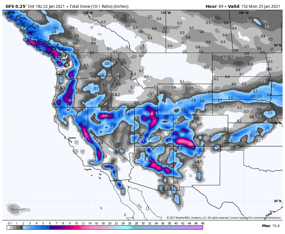
The long term is very active! There are several more storms on the horizon for the southern mountains of Utah, Arizona, southern Colorado Sunday-Tuesday. A significant storm is likely for the Sierra (Several feet) for midweek that could translate over Utah or Wyoming with additional snow (Midweek). The Pacific Northwest looks to get crushed again by next weekend. Sorry to be brief on this forecast but in chase mode currently.
Will likely update this forecast Saturday afternoon. Enjoy the powder!
Powderchaser Steve. @powderchasersteve via instagram.


