
Summary:
Several areas in the west will score powder this week. The 4 corners including southern Colorado, central Arizona, southern Utah, reap rewards through Tuesday. The Sierra grabs a moderate storm Sunday night and a \Monster Storm\" from Wednesday to Friday. Please consider a donation to support our forecasts or join our concierge if you want to score deep snow like we did last week!
Forecast:
The last forecast issued on Friday held up well in identifying the highest snow totals in Utah (Brighton and Sundance), with Colorado coming close to the forecast. The forecast for Utah was especially tricky with S, SW winds often favoring Big Cottonwood and rarely mentioned in my posts \"Sundance\" which scored 12 inches Friday night and another 10 inches on Saturday (22). We had that in the forecast, but unfortunately, mountains further north near Logan (Beaver) came up short. Surprised to see POW MOW do so well in a S, SW flow who usually scores in NW flow. The dynamics of the energy overcame this deficit, with a deformation zone setting up north of I-80 on Saturday.
Here are. a few snow totals over the past few days
Brighton- 23 inches
Sundance-22 inches
Snowbird-20 inches
Wolf Creek- 18 inches
Powder-17 inches
Park City-16 inches
Arizona Snowbowl-16 inches
Purgatory- 10 inches
Telluride-9 inches
Aspen 8 inches
We were able to score deep powder in the Tetons initially, Utah on day #2 and was going to chase to Arizona last night to score 3 States of double digits. We pulled the plug en route to AZ. Our 2-day storm total was 35 inches.
In Colorado, the focus will continue to be in the southern mountains through Tuesday, however the Front Range resorts or I-70 corridor might get a moderate refresh.
The next week will remain very active. Storms will continue to impact the 4 corners with several resorts in Colorado, and Arizona, and perhaps southern Utah coming up with powder days for Monday, Tuesday, and Wednesday. I could see another 6-11 inches for Wolf Creek by Monday morning and perhaps a repeat for Tuesday morning. Arizona should see higher amounts during this period and scores multiple powder days. Telluride who normally does not do well with SW winds could score a sneak up a surprise with some NW winds at times bringing moderate snow for Monday morning (4-8). For the starved I-70 corridor, some snow will spill north on the I-70 corridor for late Sunday or Monday for generally 3-5 inches possible for many resorts (Summit included). Bottom Line: Southern Colorado and north/central Arizona wins the game in the next few days with some freshening elsewhere in north/central Colorado on Monday.
Below: Snowfall totals through late Tuesday will bring significant snow to the 4 corners, especially Arizona and southern Colorado. In the upper right corner of Colorado (Blue 5.5) Summit County could grab a moderate amount with some of the purple colors indicating a possible set up along the Continental Divide closer to the Front Range. Maybe A-Basin or Loveland come up with higher amounts. Temps are cold so amounts could exceed the models at 10:1. The highest intensity expected Monday PM through Tuesday AM.

A low-pressure trough moves into Oregon Sunday afternoon and drops into the Sierra Range by Monday morning. Widespread amounts of 4-8 inches are possible in Oregon and up to 12 inches for the Sierra Crest. This storm will bring high-quality blower type pow for the Sierra. Groomers might be your best bet with base depths being low in CA.
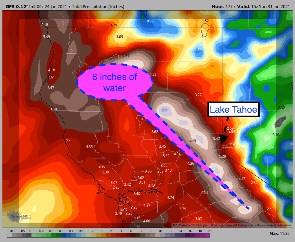
A very significant storm with an atmospheric river tap slams into the Sierra midweek
Slightly warming temps and strong winds. Snow levels will be near 4800 feet rising to 5700 at times with the highest amounts above 7,000 feet. Snow will be falling in the Tahoe Valley.
Extended:
It's so exciting to see resorts go from Zero to Hero. I mentioned an atmospheric river in my post last week. With high confidence, the Sierra will see a significant storm from Wednesday to Friday, and again late next weekend. Snow could continue in the Sierra into the 1st several days of February! The models are exploding with up to 8 inches of moisture and nearly 5-6 feet of snow this week. Additional feet of snow is possible late in the week into the following perhaps. This will deliver the storm that California has been waiting for. Many seasons have been met with just 1 or 2 storms that take the Sierra from nearly nothing to full-on winter. This is the storm that will deliver! Bring it on!


Moderate snow will be falling from the Oregon Cascades during the period (Adding up nicely next week), as well as the SE Cascades of Washington The interior portions of the Cascades near Mission Ridge are on my watch list. SE or East winds will favor that region. Areas near White Pass might also score some moderate snowfall mid to late this week. You could chase from Oregon to the Sierra perhaps.
Elsewhere light snow might trickle into the Wasatch at times next week with a moderate storm due for the Tetons late week or the following weekend (Leftovers from the Sierra).
Announcement:
Avalanche Danger is rising in many areas with the recent snowfall, especially in Utah. A slide inbounds at Sundance yesterday (On a closed run) sent a skier buried above his waist. The story goes that skier lost a ski, went under a rope to retrieve the ski, and the avalanche was triggered! Please know before you go, and respect the need for education in the backcountry, and especially closures at ski areas. The Sierra storms are going to come with strong winds midweek, slightly warming temps, and a significant uptick in Avalanche danger. It might take a while to open terrain, expect localized wind holds, closures, and all the frustrations that come with a powder chase. You might elect to hold off and wait for the 2nd round of snowfall late next weekend.
Powderchaser Steve - @powderchasersteve via Instagram. Follow our other forecaster and rider @lstone84 as well.


