Summary:
A potent cold front will bring snowfall to much of southern Montana, Central Wyoming (Tetons included) as well as Utah. Some deep totals are possible. Please support Powderchasers with a donation from our website for the winter forecasts. We will be winding down for the season in the next week.
Forecast:
Models are trending a bit further south with the incoming storm than yesterday. Snow will be falling over the Tetons, southern Montana (Big Sky, Bridger Bowl, Red Lodge Mountain favored), and extend into most of northern Utah late Monday night into Tuesday morning. Very warm conditions on Monday will migrate to a steady drop of temps overnight over these areas. The big question is much snow will fall initially with the warmer air versus the cold front. It appears temps drop slowly through the night and will be cold enough for all snow in many valley locations by 8 AM Tuesday (Benches around Salt Lake, Bear River Valley, Logan, Jackson, Red Lodge MT). You want warm bonding snow before the higher quality snow arrives or else you will be riding a pretty firm bottom after the warm temps of the past few days. It's tough for me to say yay or nay on that one (the last 1/2 of the snow might be low-density punching through to a few inches of denser layers). Could also be moderate or deep light density on the crust. Temps are pretty cold by Tuesday morning.
Snow will continue into Tuesday morning before dissipating. There are many chase options.
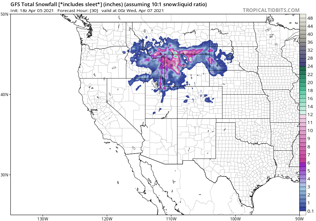
Bottom Line: Models are not all in synch but a general trend of 4-10 inches is the most likely scenario for many locations above 8,000 feet.
5-10 inches possible for the Tetons by Tuesday morning.
4-9 inches are possible for northern Utah by Tuesday morning (Logan areas mountains)
3-5 inches are possible for the Park City area, and Powder Mountain, perhaps Snowbasin (Prefers SW winds).
Please check out the lowest prep season rates on the IKON pass for the 21/22 season.
5-10 inches are possible for the upper Cottonwoods (LCC favored) by Tuesday mid-morning.
6-10 inches are possible for Red Lodge Mountain Ski Area
3-6 inches are likely for Bridger and Big Sky
Colorado gets very light leftovers for Tuesday (1-2 inches) favoring the northern mountains.
Below: Cold air (-10C at 10K) will move into the intermountain west favoring Utah, Wyoming, and to a slightly lesser degree in Montana late Monday night. (Midnight to 7 AM will be the coldest period). Quality could be pretty light density however you might be feeling some pretty funky bottom layers with the sharp temperature differences.

Below: Total Liquid Precipitation per the Short Term High-Resolution Model (HRR) noon on Tuesday. Very heavy moisture in east of Jackson over the Wind River Ranges. Decent totals for the Tetons, northern Utah, and perhaps Red Lodge. Some models show higher amounts near Red Lodge however .75 inches of liquid would still be in the 7-12 inch range. The Cottonwoods in Utah will benefit from cold air and NW winds so could land some surprises not shown here on the models.

Snow is likely for the Cascade Range beginning Wednesday or Thursday (More on a later post)
Enjoy the Powder everyone! Please report back or comment if you are chasing, chases, reading this post, or provide a post chase follow-up.
Powderchaser Steve


