
Forecast Discussion:
In our last post, we talked about the pattern change for the West. The signals are all coming together with high confidence in several systems to slam into the West in the next 7-10 days. Initially in the Rockies, these storms (this week) will be on the warm side. The Sierra will see moderate to semi-deep powder as early as Wednesday.
The models, even 24 hours out, are showing significant differences for the Sierra storm due Tuesday night. Most show a trend for the southern Sierra (Mammoth) to be the deepest, with a few pushing moisture further north. Southerly flow can sometimes present challenges as to who scores he highest totals.
Utah grabs decent leftovers by Wednesday afternoon. The upper Cottonwoods (BCC is favored) might see 9-15 inches of snow by Thursday above 8,000 feet (Snow levels start at 7500 and trend down by late Wednesday night). The Uinta Range (Park City Powder Cat Skiing) in the Uinta Range should do well with this storm
The Tetons are on the northerly end with moderate totals. In Colorado SW flow will favor the central mountain ranges and extend north to Steamboat. The core of the I-70 Corridor resorts are likley getting light to moderate totals. Vail Pass is a wildcard. Aspen is a wildcard with SW flow pushing into the Elk Mountains; however, most of the moisture appears to be south towards Gunnison County (Irwin Lodge, Crested Butte).
Sierra Storm Tuesday night
Below: National blended models showing 6-10 inches for the northern Sierra Crest near Lake Tahoe, with higher totals likley for Mammoth (Southern areas). Kirkwood might also trend a bit higher. There might be higher totals in South Lake, as well as the far north, closer to I-80 (Models are still not in full synch). This will be a warm storm to start (6500-7K) and finish colder (5000 feet).

Below: The short-term HRR paints a similar picture with nearly an inch of water along the Sierra Crest (Tahoe's higher peaks), and nearly 2 inches of water (Reds), setting up closer to Mammoth in the south. Note: A few models show higher total near I-80 up north, so it is possible some surprises along or closer to I-80 pop up (Sugar Bowl). Caveat: South winds can sometimes limit snowfall totals vs. SW, NW flow, so some areas could underperform the models.

Rockies Wednesday-Thursday (UT, WY, CO)
Below: Moisture from the Sierra decays; however, the faucet is still pretty moist over Utah and central Colorado with some double digits likley Wednesday/Thursday. Warm air on Wednesday (Peak snowfall for Utah) will limit totals below 7500 feet (Rain possible at the base of PCMR or DV); however, cooler air moves in Wednesday night/Thursday with moisture continuing albeit lower intensity. SW slow will favor the upper Cottonwoods (BCC can do better than LCC), and the upper aspects of Deer Valley. Sundance might grab good totals at the summit. Thursday morning might be your best bet in Utah. Areas above 8K in the Cottonwoods could see 9-15 inches of snow, while lower mountain ranges near Park City could see 5-10 inches (Above 7500).
The Tetons are on the light to moderate end of the spectrum, while Colorado nabs up to 10 inches just south of Aspen into Gunnison County. Steamboat is a wildcard as SW flow can pump decent totals into that region. This is a warm storm, so ratios (Liquid to snow) are on the low side; however, higher terrain elevations in Colorado are a bonus. The central mountains could see 6-10 inches, while areas along I-70 in the 3-6 inches. Aspen is a wildcard (3-6 or 5-10). Vail Pass might also sneak up a few surprises per a few models; however, with the lack of NW flow, my confidence is low.
 Below: Total precipitation through Thursday morning, showing 1.5 to 2 inches in northern Utah (Cottonwoods, Uinta Range east of PC) and up to 1/2 inch of water in the northern regions of the Wasatch. There is also good moisture showing up in a few areas of Southern Utah (Eagle Point, perhaps). SW flow can also be good for DV and Sundance (South flow is ideal). Colorado grabs the typical SW flow highlights in the central and far northern mountains (Steamboat) with lower totals along I-70 or in the far south.

The Extended Forecast is the most exciting outlook we have posted all season.
Snow enters the picture later this week for BC mountain ranges (Western BC is favored) and drags south into the northern Cascades of Washington by Friday (5-10 inches). The weekend drags a deeper storm into the Sierra range by Monday morning. The pattern of double digits hitting the Sierra Range with weakening leftovers spilling into the Rockies continues for much of next week. While the Sierra might nab 4-6 feet or more of snow next week, some areas of the Rockies should be able to pick up an additional 2 feet of snow as weakening atmospheric river events traverse east.
Late Week Storm PNW/Canada (2/13 to 2/14)
Below: Areas of BC fill in with snow again by Friday, extending south into the Cascades by Saturday (Northern areas are favored with SW flow). Temps are relatively cold with this storm.

Sunday into next Week 2/16-2/23- storms continue
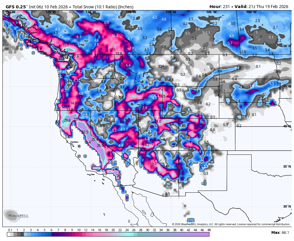
Below: 24-hour snow increments from this Sunday night through next week. You can see several 24-hour periods of double digits in the Sierra initially pushing into south central Idaho, Tetons, Utah, AZ, and to some extent Colorado (Weakening). These strong AR events in the Sierra will weaken as they move east but still have chances of multiple rounds of moderate snow in the Rockies.
The latter portion of this map (Later next week) shows a good storm entering Oregon, pushing south into the Sierra. This might favor a more southerly track over the Four Corners, extending deep snow into Utah, AZ, and Colorado (NM wildcard).
Bottom Line: We are simply too far out to forecast details. The trend is for deep snow to continue in the Sierra and spread decent leftovers east. Track is TBD. Some areas of the Sierra will be measuring 14-day totals in the 6-8 feet range! Decent confidence in the Rockies with a weakening plume landing 2-4 feet of snow. Link to our Concierge Packages for day-by-day chase guidance if you are looking for the best conditions.

Forecaster: Powderchaser Steve @powderchasersteve (Instagram)
HELP US OUT- Please support your love of powder and our free forecasts with a donation here, or join our concierge program. We have merch on the website.
We appreciate the support for these free forecasts.


