
Summary:
Impressive amounts of wet snow (18-24 inches) have fallen in some areas of the PNW. Snow continues changing to rain by late Monday. Modest storm likely for the Rockies and Sierra late this week into the weekend.
Announcement: Please join our concierge program if you are looking to chase the deepest snow and need custom forecasts. These will likely be the spots we end up chasing. You can support our free forecasts by donating if you simply are living vicariously or chasing on your own. There are a few seats still open in March at Alaska Backcountry Guides in Valdez Alaska who we highly suggest! Mention Powderchasers for a free concierge package when booking.
Forecast:
A warm atmospheric river is pounding the Cascades with impressive snow totals as of Monday morning. Mt Baker grabbed 8-10 Sunday and another 18-19 inches overnight into Monday! Temps are near freezing at mid-mountain and warmer at the base. Significant Avalanche Danger will likely exist due to the high moisture content of the snow so be sure to check your daily Avalanche report or simply stay out of the backcountry today. Temps will be rising Monday into Tuesday with rain likely in many areas of the Cascades at mid and lower elevations. Avy danger will continue to rise in these areas.
Below: Impressive amounts of snow for Mt Baker Sunday night. Stevens Pass also grabbed double digits. Warming has occurred in these areas with surf snow a guarantee mid to upper elevations.

Schweitzer Ski Area near Sandpoint Idaho nabbed 8-9 inches Sunday night where it is still snowing heavily. Temps are also near freezing so expect dense surfy snow, no bottom, and some fun turns today before the warm-up Monday night. Selkirk Powder will be deep today if you are cat skiing or on snowmobiles early this morning. Please check out Selkirk Powder for your ultimate backcountry experience in Northern Idaho. They have had a good snow season!
Below: Schweitzer Ski Area Monday morning in the full pow mode albeit dense. Deep surf day!

Temps peak in the PNW late Monday into Tuesday with the 4800-foot temps in the 2-3C ranges (37F) so any additional precipitation is likely to fall as rain at most elevations other than the highest peaks of the Cascade Range. It's even warmer in the southern Cascades (6-7C at 4800).
Below: Temps are rising in the PNW (Well above freezing in the southern Cascades and 2C at 4800 feet in the north) on Monday PM through Tuesday night. Slightly cooler conditions exist for southern interior BC however with lower elevation base areas rain is likely there also. Courtesy of WeatherBell.

Extended Pow
The week ahead will feature cooler temps and a good chance of snow for the Sierra and Rockies. The models have been flip-flopping from a semi-deep Sierra Storm to a modest event. Today the models are indicating that snow will develop by late Thursday and continue into Friday for the Sierra. Amounts appear to be in the modest range and might favor the southern ranges towards Mammoth. Decent confidence exists for some snow for all ranges of the Sierra late this week with a bit less confidence on exact amounts or pinpointing the deepest spots. The American model shows equal amounts north to south with the European favoring the southern Sierra.
That system drags over Nevada towards Utah Friday morning to Saturday. The American GFS shows moderate to perhaps more favorable amounts for the Wasatch, Central Idaho (Brundage), and some snow for the Tetons late this week. The European keeps the highest moisture a bit further south over central Utah. Bottom Line: High confidence for snow for many areas of the Rockies as the Sierra storm heads east. Models still show a discrepancy on the exact track and who sees the highest amounts. Wind directions from the NW, and West are favorable for many areas of the Rockies. Amounts from this storm are likely going to be in the modest range. Some upside is possible over the Wasatch or central Idaho.
Below: Low pressure Trough set up over the Sierra and Rockies late this week into the weekend.

Colorado might end up faring best if you want to believe the model runs from this morning. The GFS is the slowest with heavy snow being depicted over the Front Range resorts late Saturday through Monday (Moderate amounts along I-70 with heavy snow closest to Denver). The European model shows a deeper trough setting up over I-70 early Saturday through Sunday with widespread snowfall for many locations. The Canadian shows a bit less snow. Bottom Line: Bullish for some deep snow for Colorado at some point from Saturday to Monday. The models are diverging on timing (Early Saturday or late Saturday night or Sunday). Pretty confident in many ski areas seeing snow from north to south, a bit more confident on the Front Range, however, if the European Model pans out I-70 might be deep next weekend.
Below: Low pressure still noted over the west as of Monday morning with slow movement. This might fare well for Colorado late this weekend or early next week.

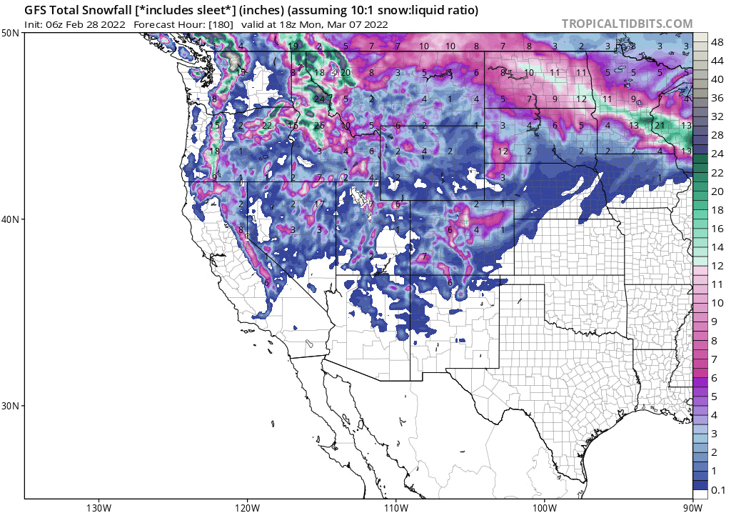
Below: Total snowfall for the west through Monday. Low confidence with this map 7 days out, and 1 model run (GFS). I am sharing as a precursor and hopefully to boost the endorphins while you are out biking this week in the warm weather. Most of the PNW snow is occurring early this week with the warm temps. CA/ID/UT/CO/WY come late Thursday to the weekend (modest event with some upside in a few areas). Put the bikes away late this week or weekend.

Below: Looking further out into March 7-10 there is a trend for low pressure to continue in the west. This may be the trend until at least mid month. Courtesy of WeatherBell.

You can follow my adventure on Instagram @powderchasersteve for travel, snow, and wildlife photography.
Enjoy the powder everyone.
Powderchaser Steve


