
Wednesday is the first true powder day, with the best opening move in southern Colorado and the Wasatch before the sweet spot slides north into Idaho, Wyoming, and Montana late Thursday into Friday. Wolf Creek, Alta, Snowbird, Brundage, Grand Targhee, and Big Sky sit on the short list, while the Sierra and Oregon Cascades still score useful snow but deal with denser flakes and more wind.
This will be a dense storm initially until cold moves in later in the wet cycle. Snow levels in many areas of the West hover from 7-8500 feet until the colder air arrives Thursday/Friday.
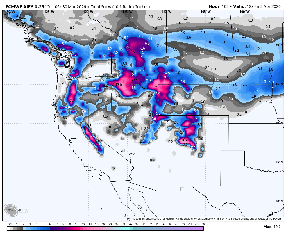
Confidence is highest from Tuesday morning, March 31, through Friday afternoon, April 3. The guidance is aligned on a two-step cycle: a warmer first wave that favors high bases in the Sierra, Wasatch, and southern Colorado, followed by colder air that drops snow levels hard and delivers the best snow quality to the Northern Rockies by Friday. Wind is the main quality hit, especially on exposed Tahoe, Oregon Cascade, and Wasatch ridgelines. This is not an early April Fools Joke!
Resort Snowfall Totals for March 31-April 3
- Jackson Hole: 12-15 inches
- Brundage: 14-18 inches
- Solitude: 9-15 inches
- Brighton: 10-15 inches
- Grand Targhee: 12-18 inches
- Wolf Creek: 10-18 inches
- Big Sky: 12-18 inches
- Snowbird: 15-25 inches
- Alta: 15-25 inches
- Kirkwood: 9-15 inches
- Bachelor: 11-18
Storm Timing and Discussion
The first wave gets going Tuesday in the Sierra and spreads into Utah and Colorado Tuesday night through Wednesday. Timing is fairly well aligned, and the main question is intensity rather than whether the storm happens. This will be very dense snow.
Snow levels start relatively high, generally around 5000-8500 feet in the Sierra, 7000-9000 feet in Utah, and near 8000-9500 feet in southern Colorado, so higher bases cash in first. That is why Wolf Creek looks so good early, with snow falling during the day on Wednesday. Kirkwood looks best in California at 9-15 inches, and Alta and Snowbird build toward 15-25 inches.
The second part of the cycle arrives Wednesday into Thursday as colder air pushes into the Pacific Northwest and Northern Rockies and then wraps back into Colorado. Here, the guidance converges better on timing and snow-level drops than on exact totals. Snow levels fall to around 2000-5000 feet in the Pacific Northwest and close to valley floors in parts of Utah, Idaho, Montana, and Wyoming by late Thursday into Friday, so snow quality improves sharply even where totals are not the biggest. Late Thursday or early Friday might show the best quality in the Rockies.
Confidence softens a bit on who wins the Wasatch because snowfall spread is wider there than it is in the Tetons or Washington Cascades, and one wetter solution remains much more aggressive than the rest. Even so, every solution still supports a meaningful Wasatch cycle. The bigger universal issue is wind: gusts into the 50-70 mph range on exposed ridges in the Sierra, Oregon Cascades, and parts of the Wasatch will knock back quality at times, while Idaho, Wyoming, and Montana look better positioned for colder, cleaner skiing by Friday. Winds decrease with the colder air as colder air and NW flow set up Thursday/Friday.
Daily Chase Recommendations
Each day's snowfall range combines the previous night (4 pm-8 am) and that day (8 am-4 pm).
Wednesday

Above: ECMWF Wednesday snowfall (Colorado).
- Wolf Creek is the top Wednesday target with 8-12 inches of moderate-density snow and enough elevation to keep the whole storm in good shape.
- Alta and Snowbird are the best Wasatch calls with 10-15 inches of moderate to-dense snow.
- Targhee will also be in the hunt with 5-11 inches of dense snow, slightly lighter than the Wasatch.
Thursday

Above: ECMWF Thursday snowfall (ID/MT/WY).
- Brundage is the cleanest Thursday chase with 5-10 inches of moderate-density snow, colder air, and much less wind than the Utah and Oregon options.
- Grand Targhee and Jackson Hole stay in play with 5-10 inches additional snow on top of a solid two-day base, though ridgeline wind will still be noticeable.
Friday

Above: ECMWF Friday snowfall (ID/MT/WY).
- Big Sky is the Friday standout with 5-10 inches of blower snow and cold, manageable wind, preserving the best quality of the cycle.
- Steamboat is the best Colorado fallback with 7-11 inches of fluffy snow, though it still trails the Northern Rockies on both depth and quality.
- The Wasatch range and even Targhee can sneak up some blower powder Thursday night (4-8).
Extended Outlook
After Friday, the storm track shuts down quickly. Saturday through at least Monday trends warmer and much drier across the West, which should help snow preservation at the higher, colder resorts but end the active chase cycle. Early next week, only the far Pacific Northwest shows a weak light-snow signal, and the broader pattern still leans warmer than normal with limited precipitation across most western ranges.
WE NEED YOUR SUPPORT: Please support Powderchasers with a donation below or check out our Merchandise and Concierge packages (Custom chases 1:1). These support the free forecasts each season. We are


