
The last few days brought some decent totals to the Sierra, PNW, and the southern San Juan Range. Selkirk Powder Guides in north Idaho scored as forecasted with an excess of 12 inches of snow with much more to come. Selkirk Cat Skiing will be filling slots as we see another 12-18 inches in the next 72 hours. We also predicted decent dumps for Whitefish that had powder on Saturday/Sunday.
Summary: The week ahead will be very very deep in the PNW (Coastal BC) with 2-5 feet likely, especially for WA and OR. Moderate leftovers will aim towards the interior of BC and the northern panhandle of Idaho with 12-15 inches in the next 24-48 hours. Northern Montana will also stay in the flow. The Tetons finally get back on the map with double digits with the Wasatch and northern Colorado scoring. Southern Montana high unfortunately stay on the moderate end of the spectrum but will see snowfall from these storms.
Recap: Sunday morning totals came in as we had forecasted with an initial wave of 4 inches for the Cottonwoods (BCC grabbed less than we expected) and 10 inches for Snowbasin (we mentioned heavier totals in the northern Wasatch). Moisture dropped south during Sunday and by 2 PM roughly 10-13 inches had fallen in many areas of both the northern and central Wasatch (Snowbasin, Powder, Alta, Sundance). Big Cottonwood underperformed as well as Park City (4 inches).
Powderchaser Steve chased to Snowbird where 4 inches grew to 6 by opening, and 10 by 1 PM. Storm totals are at 14 inches. Snow quality was light and if you hit the right areas that were not noisy underneath I would give it a solid 8-9 on the powder scale. The canyon was a nightmare with some folks taking 1-2 hours to get to the ski area (Accidents). I avoided that.
Below: @powderchasersteve hiking at Snowbird with 3 hike laps of 10-12 inches of low-density powder.

The week ahead will be very deep. This is the real deal! We will summarize in a few paragraphs.
PNW-
Very moist system pounds the PNW and BC (Coastal ranges are favored) peaking Monday PM to Tuesday PM. Expect 20-28 inches at most of the western Cascade Resorts, with 12-18 in western BC (5-10 interior). West and northwest winds provide opportunities for high snow totals for most resorts in WA and OR. Models are pointing to the high-end totals toward Stevens, Crystal, or White Pass. Oregon grabs high totals later Monday night into Wednesday morning. Models show a similar to path to the last storm with Schweitzer grabbing an excess of a foot with decent leftovers aimed at Whitefish (We called this on the last forecast). The Good: Game-changing amounts of snow (2-3 inches per hour Monday night into Tuesday), High quality (Starts with a warm front raising snow levels to 4800 feet, and finishes very cold). The Bad: Strong winds Monday night into Tuesday will likely keep upper terrain either closed (Extreme drifting), or lifts closed due to wind. Bottom Line: A risky chase for Tuesday with a high risk of closures (Roads or lifts), but if things remain open, it will be all time. Additional and significant totals will follow this 1st wave this week in the PNW.
Below: Total snowfall through Tuesday morning in the PNW will be very deep with 2 feet or more at many resorts. 12-18 inches are possible in northern Idaho with 6-10 for the eastern side of the Cascade Crest. Oregon will see snowfall increase on Tuesday so totals will exceed the map a bit by Wednesday.

Sierra
The Sierra grabs another similar shot of snow as the last storm. We can see totals in the 10-18 inch range for the Sierra Crest with most ski resorts doing best Wednesday (Storm ski) extending into Thursday albeit with lower intensity snow rates. Bottom Line: A good chase without many red flags. Storm ski on Wednesday and ride new snow on Thursday. More in the extended.
Below: Cold airmass is taking hold of the west with 10K foot temps in an ideal sweet spot of -15C for good snowfall production (Good density and high snow/water equivalents). The Sierra will see decent lake-level snow on Wednesday.

Idaho and the Rockies
Very high confidence in 12 plus inches for northern Idaho, from Sandpoint including the northern and central Panhandle. Central Idaho will do well with slightly lower amounts (8-15) Highest precipitation rates will be late Monday night or into Tuesday evening. Tuesday will be a full-on storm day. Bottom Line: A good chase with lower risks of road or lift closures than areas in the western Cascade range. Not as deep, but deep enough!
The energy will track north into Whitefish and south towards the Tetons, Wasatch, and northern Colorado midweek. Expect 5-10 inches for the Tetons by late Tuesday night or Wednesday morning. Southern Montana once again gets grazed with lighter totals (3-7). The Wasatch will score 5-10 inches by Wednesday morning with increasing winds and continued snowfall. In Colorado, we have higher confidence in moderate totals for the northern mountains from Steamboat to perhaps the I-70 corridor (4-8 by midday Wednesday). Bottom Line: Good chases with moderate totals likely overnight Tuesday. Snow continues Wednesday with conditions improving and snowfall totals possibly exceeding 12-15 inches in the Cottonwoods. Some models show higher totals with this storm in the northern Wasatch (Snowbasin, Powder, and Beaver). Winds on Wednesday might keep upper lifts closed, especially in LCC so it can come with a bit of risk (Gusts in the 40s and 50s at 10K).
Below: U or U model based only on the GFS shows a steady stream of snowfall for LCC peaking Wednesday and again likely later this week into the weekend.

Below: Total snowfall for the Tetons will likely exceed 10-15 inches by late Wednesday with decent confidence in the models (Tight lines).

Below: WOO- The U or U ensemble data showing 25-50 inches possible at Crystal (Cascades crest will see similar totals in many locations) this week. This will take some time to mitigate and get the terrain open. Peak snowfall rates will be from Monday night to Tuesday.

The extended continues to put us in the White Room.
The extended brings a continued pattern of unsettled weather for the west. There will be short breaks next week between storms with multiple periods of moderate snowfall continuing in the PNW and Rockies. There seems the be a bump in precipitation rates as we approach the weekend.
Below: This map shows the trend from Thursday to Sunday in 12-hour snowfall increments (An easier way of seeing where the largest totals will be falling). These 12-hour snowfall increments seem to take a northerly route initially late this week (PNW, Northern or Central Rockies) with a better chance of storms dropping a bit further south into the Sierra by the weekend. Deep periods are noted especially for the weekend. Storm totals in the west might exceed 4-6 feet this week, especially in the PWN and a few areas in the Rockies. Finally, the Tetons seem to be firing again! Snow ratios will be better than 10:1 as shown on this map so expect even higher totals than shown.

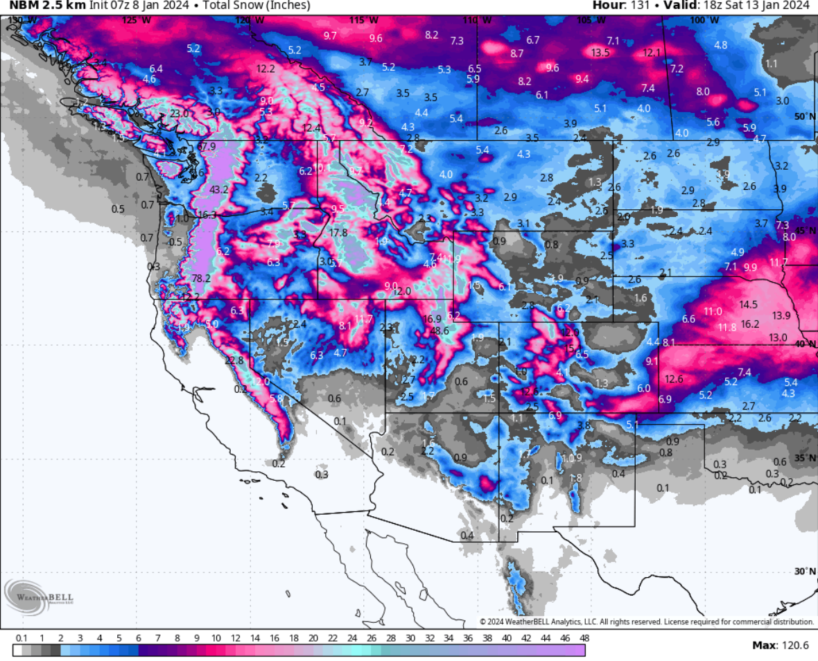
Below: Total snowfall through Saturday, January 13th in the west. The National Blended Model shown here is often overdone taking a mix of high-resolution and deterministic models (Can sometimes highlight higher peaks in the ranges outside the ski areas). In the case of colder temps and high snow-to-liquid ratios, we decided to share this map as a reasonable prediction of total snowfall. The takeaway is widespread 40 inches or higher totals are noted for many areas this week. The southern San Juan Range will see lower totals with areas along or north of I-70 seeing the highest totals.

Help us out!
If you want to chase powder with Powderchasers sign up for the concierge package for the deepest resorts to chase to and 1:1 custom forecasting with our staff. Also, if you have read this far, please donate to continue receiving these free forecasts. We appreciate the community support. You won't regret chasing with our custom forecasts. We have new swag on the Powderchasers storefront and all larger donations include it.
Follow us on Instagram and Facebook @powderchasers
Enjoy the powder, everyone! Remember, your deepest resort is not always the best chase. See you in the first chair.
Powderchaser Steve @powderchasersteve - Instagram


