Good afternoon powder lovers with your quick Saturday afternoon update. Heavy snowfall continues to fall over the Sierra Range with very strong winds. Gusts at 8700 feet are in excess of 100 MPH with most summits currently closed (Sunday could be deep but windblown). As of 4 PM, Palisades Telemetry is showing 17 inches as of 5PM at 8000 feet. Significant snowfall is occurring in the entire range of the Sierra (Lake level) with strong winds.
Below: At 8700 you can see 111 MPH gust around 1345 today. Reno saw a wind gust of 72 MPH this morning!

Short term models which we often put high accuracy with are showing an additional 6-11 inches from late PM Saturday to early Sunday. Sunday could be epic in the Sierra in less wind prone locations. Please be careful in the backcountry with significant wind loading. Storm totals will exceed 20-25 inches in some locations by Sunday.
Below: You can see heavy snow bands continuing in the Sierra Range through early Sunday morning (Another 6-11). Lake effect is also possible with the warmer temps of the water and very cold airmass moving in. Mammoth or Kirkwood might be slightly favored Saturday evening but all areas will see additional pow.

THE DUMP OF THE DAY COMPLETELY SNUCK UP ON US AT STEAMBOAT WITH 19 INCHES IN 48 HOURS!

Below: Whistler was also very deep Saturday and was on our forecast where huge crowds of locals lined up for the Peak Chair. Spankeys Ladder also opened Saturday.

THE NEXT 7 DAYS WILL STAY VERY ACTIVE WITH MANY STORMS PUSHING THROUGH THE WEST. EPIC ALERT MIGHT UPGRADE TO SNORKEL ALERTS.
Below: 12 hour total precipitation starting Sunday morning focussing on the Sierra, Northern Idaho (Selkirk Powder Guides, Schweitzer)l northern Montana, Wasatch, and the 4 corners. You can see the deeper blues favoring the southern areas with the Wasatch range on the cusp. You can see storm #2 approaching the Oregon coast by Monday night (Tail end of this loop).
 Storm totals from Saturday night to Sunday night will likely be in the 2-5 inch range for the Tetons, 7-12 inches for the Wasatch, and 10-17 inches for some resorts in the 4 corners.
The Wasatch will see a 60% split of Saturday overnight and 40% for Sunday AM snow. (4-7 by lift opening). Winds in the Wasatch are SW until 5 AM Favoring BCC, Park City, and perhaps Sundance and Snowbasin. Winds shift NW early Sunday enhancing snowfall for the Canyons side of Park City and the Cottonwoods. If lucky we will see an upside surprise by midday Sunday. Perhaps similar totals to the departing system.
The 4 corners grab most snow early Sunday to late Sunday night (Storm ski). Arizona SnowBowl is likely to grab 4-8 inches with higher amounts noted for the southern Colorado mountains (9-15).
Less snow will fall in northern or central Colorado. Of note, one model shows a chance of a sneak up 4-8 inches for the Aspen area mountains or south towards Irwin Lodge or CB. Telluride might benefit from NW flow on the backside of the low which predominantly is SW flow (Wind direction is perfect for the San Juan Range). Taos has a decent chance of 7-11 inches from Sunday midday early Monday.
THE NEXT 7 DAYS WILL BE DEEP WITH ULLR ON OUR DOORSTEPS.
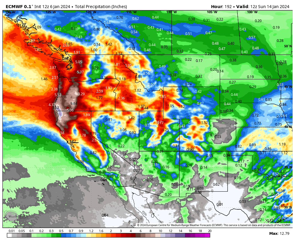
Below: Map is from Monday January 8 to Sunday January 14.
24 hour precipitation totals with the day/date in the upper right corner. You can see heavy periods of 24 hour moisture totals in the PNW, western BC, Sierra, Northern Idaho, northern Montana, Sierra, with weakened but strong leftovers aimed at portions of the Rockies. The latter period towards the end of next week shows a stronger system taking a bit of a more southerly path over the Sierra.

Bottom Line: Several waves of moisture which will = lots of snow with the cold temps (High snow ratios). This is a big week so get ready!
Below: Very cold air moving over the PNW and Rockies early to mid next week with the next storm. When you look at the temps and amount of water aimed at the west this could end up bringing 5-7 or more feet to some locations in the PNW.
Some areas of the Rockies could end up with 30-40 inches from Sunday to Friday (Multiple events late this weekend, midweek and late week).. The Sierra will also score big totals.

Meanwhile in the East the next storm is going to bring near or above freezing temps to the coastal areas with snow totals in excess of 10 inches for the southern regions.
Below: Short term high resolution models showing the best chases might be western MA, Southern Vermont, and near Gunstock in the Lakes region of NH. Sunday River might eke out some decent totals also albeit less than the extreme south. This storm definitely will favor southern regions with 9-12 inches of snow and 4-7 inches possible further north in VT, NH.

Help us out!
If you want to chase powder with Powderchasers sign up for the concierge package for the deepest resorts to chase to and 1:1 custom forecasting with our staff. Also, if you have read this far, please donate to continue receiving these free forecasts. We appreciate the community support. You won't regret chasing with our custom forecasts. We have new swag on the Powderchasers storefront and all larger donations include it.
This post is sponsored by Selkirk Powder Guides in Idaho who offers remote Cat Skiing. They are about to nab some deep snow!
Follow us on Instagram and Facebook @powderchasers
Enjoy the powder everyone!
Powderchaser Steve @powderchasersteve - Instagram


