The start of 2022 has been good to us powder lovers. There's plenty of snow to be found at many ski areas thanks to an abundance of snow as of late. For some, the snow has slowed down though. For other, not so much.
Powderchasers has logged over 200 inches of powder in the last 9 days (Sierra, Wasatch, PNW, Tetons). If you want to chase powder to the best locations and need custom information not found in our posts join our Concierge program. Or simply donate to Powderchasers if you simply like reading our forecasts. We are a small group of 4.5.

Looking at the interpolated 72-hour snowfall analysis, the Cascades and the northern Rockies have seen some great snow. Utah and Colorado have seen a decent amount as well with over a foot being reported in the last 24-hours in many areas.

Unfortunately a warm front has pushed out the colder air in most of the PNW (Mountain passes are closed due to extreme avalanche danger), and even the Rockies (Rain-snow mix in Jackson). In Colorado very cold temps and high quality snow exist near or east of the Divide with denser snow west of the Divide. Our suggestion for the next chases are to stay as far north as possible in the PNW or Rockies. Cooling will begin in many areas by Friday.
Looking over the Northern Pacific, a small chunk of energy floating about with be sucked into the main flow. This is our next system to watch starting Thursday. Initial snow will start falling in the Washington Cascades by and British Columbia (where some snow is already falling). Snow will move slightly south into northern Oregon but mainly will have a easterly component to it. So northern Idaho and Montana will set up nicely here will some favorable wind directions. The same could be said for the Washington Cascades which will see the bulk of this moisture.
Snow will make it down to California, Utah and Colorado with this storm but nothing to get too excited about - although even a little bit of fresh powder is still powder. After this storm pushes east by Sunday, the forecast looks a little not-so-great. A ridge looks to be setting up shop over the western US starting next week so we could be in for a dry, snowless forecast for several days. Hopefully, it'll break down quickly but I'll say I'm not too optimistic about that based on how intense our swings from snowy to snowless to snowy to snowless we've been this season. I'm just happy our recent snowy period was as good as it was.
I digress, here's what you came for. Snow totals.
PNW

Snow beings today and ends Saturday for the PNW. Areas like Mt. Baker and Stevens Pass should have some pretty amazing and deep powder for Friday and Saturday (Dense heavy snow initially improving on Friday). Over 3 feet of snow could fall there. The Oregon Cascades are looking at less but still decent powder by Saturday. Around a half-foot of snow is expected for Mt. Bachelor and Mt. Hood. Inland areas will see some good snow as well with northern Idaho looking deep.
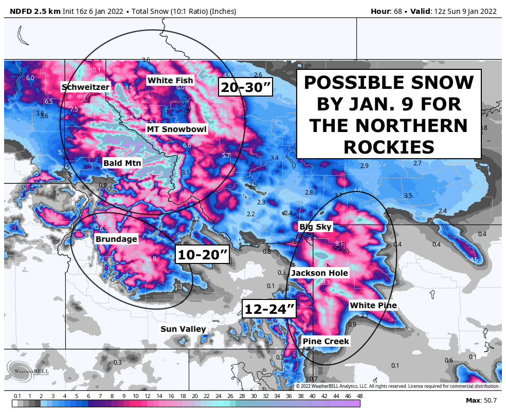
NORTHERN ROCKIES

Northern Idaho (Selkirk Powder Guides) may have some gnarly surprises with this storm. Up to 3-feet is possible in some locations but a bit more is not out of the question for some favored western slopes. Temps and wind might provide some delays or quality (50/50 chance). Wyoming will have a nice showing of deep powder to play in with 1-2 feet expected Thursday to Saturday from Pine Creek to Jackson Hole (initially wet and dense, slowly cooling on Friday). Montana will grab a good storm for Whitefish (Cooler temps) and perhaps Montana Snowbowl just outside Missoula. If you are near Montana check out these resorts.
CALIFORNIA

California, this is not a storm for you but areas in northern California will see a few fluffy inches of snow by Saturday. This storm is not dropping very far south so the further south you go, the less snow you get.
UTAH and COLORADO

Utah and Colorado are in the midst of one exiting storm today. That will drop a couple more inches of snow by tonight. Out next round of snow moves in Friday and lasts through Saturday. As is with California, the further south you go the less snow you get. The northern Utah and northern Colorado ski areas will be the best places to be for the deepest powder. Although it's not looking to be more than 6\" in any given area.
Enjoy the snow!
Powderchaser Andy
Twitter | Instagram | Facebook | YouTube | Tik Tok


