Summary:
As New England dries out this week, the west grabs a cold front, and some moderate to heavy snow possible for the central panhandle of Idaho and the interior of Montana next week. Northern Washington might also be chase-worthy by Sunday. Hopefully you realized that our post yesterday was our annual April 1st awakening. Did anyone actually book flights?
Forecast:
New England grabbed up to 8 inches from the departing storm with Jay Peak on top and Whiteface only reporting 4-5 inches (We thought they would see higher amounts). Further south including New Hampshire resorts only a few inches fell at some of the Ski Areas.
The bulk of the moisture in the short term will focus on British Columbia where an unsettled pattern continues into the weekend. This will favor western sections of BC where temps are cold enough for all snow at most resorts. Further inland temps are warmer and snowfall amounts will be less, with the exception of perhaps resorts north of Revelstoke. Most of the snow for Canada will occur midday Saturday to Sunday evening (Many resorts are closed so be sure to check before heading out).
Check out the lowest pre season IKON rates above . We depend on multiple passes for chasing powder every season and often renew early.
Late Saturday or Sunday snow will drop further south over the Cascade Ranges of Washington. Models currently depict some decent amounts are possible near Mt Baker with lighter amounts further south. The timing is good with most of the snow falling after the lifts close on Saturday. Colder air is depicted over Bellingham on the models with a warming trend as you move further inland. I am not sure what this will ultimately mean for the Ski Area. It's possible the warm air on the models is hung up on the eastern side of Cascades. More on snow quality in a future post.
Below: Total snowfall for BC through midday Sunday. Heaviest amounts on the western side with some moderate amounts noted in the central Interior (Revy or north). Some of this snow will trickle south over the northern Cascades of Washington for Sunday morning.

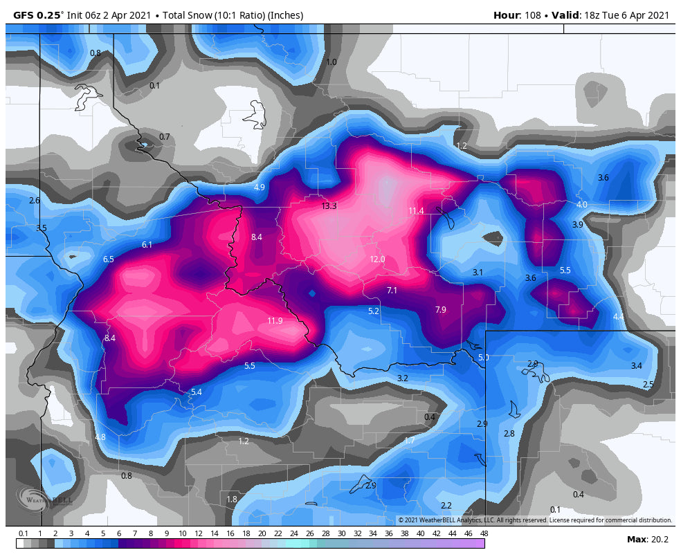
Models are showing a decent cold front moving over central Idaho next week. There will be a very rapid cool down and some moderate to heavy bands of snow possible. Currently, areas to watch are the McCall area mountains for Monday afternoon into Tuesday (Moderate snow). Snow will be falling, perhaps heavy at times for the central panhandle of Idaho (Just south of Lookout Pass) into central Montana. Models show heavy snow is possible for areas east and south of Missoula. This might include Great Divide Ski Area, Showdown, and even Discovery. Further north towards the Montana Snowbowl lighter amounts is possible. We need to watch the models as we get closer. The GFS is the most bullish, while the European is less so.
Further south some snow will also be falling in the Tetons early next week, however, amounts might be on the light or moderate side.
Below: Sharp cold front approaching the Tetons Monday night kicking off snow showers. Moderate snow is also possible for Bridger and Big Sky.

Below: Total snowfall through Tuesday mid-morning focusing on central Idaho (Just west of McCall), and especially interior Montana east or south of Missoula (4.9 on the map is Missoula). It's possible that Bridger Bowl and even Big Sky score some moderate amounts during this period. The Tetons will see lower amounts but with colder temps there could be some outlying surprises.

Enjoy the powder everyone!
Powderchaser Steve


