SUMMARY:
Last night saw storm #2, for the PNW, slightly stronger than the Monday event with another one on its heels for Friday. That system will bring another moderate event for Friday morning POW. The Rockies stay warm and dry getting teased late this weekend. The Sierra has mixed models showing snow likely for Saturday/Sunday. Nothing looks overly deep with the exception of perhaps the PNW or Whistler for Friday morning. Week #2 shows some hope.
FORECAST:
Storm #2 produced moderate snow for the Cascades for Wednesday morning with 7-8 inches at Stevens Pass as of 7 AM (Overnight). Light snow will continue this morning albeit weakening and dropping south towards I-90 under a non-impressive convergence zone. Additional accumulations of 1-3 inches are possible.
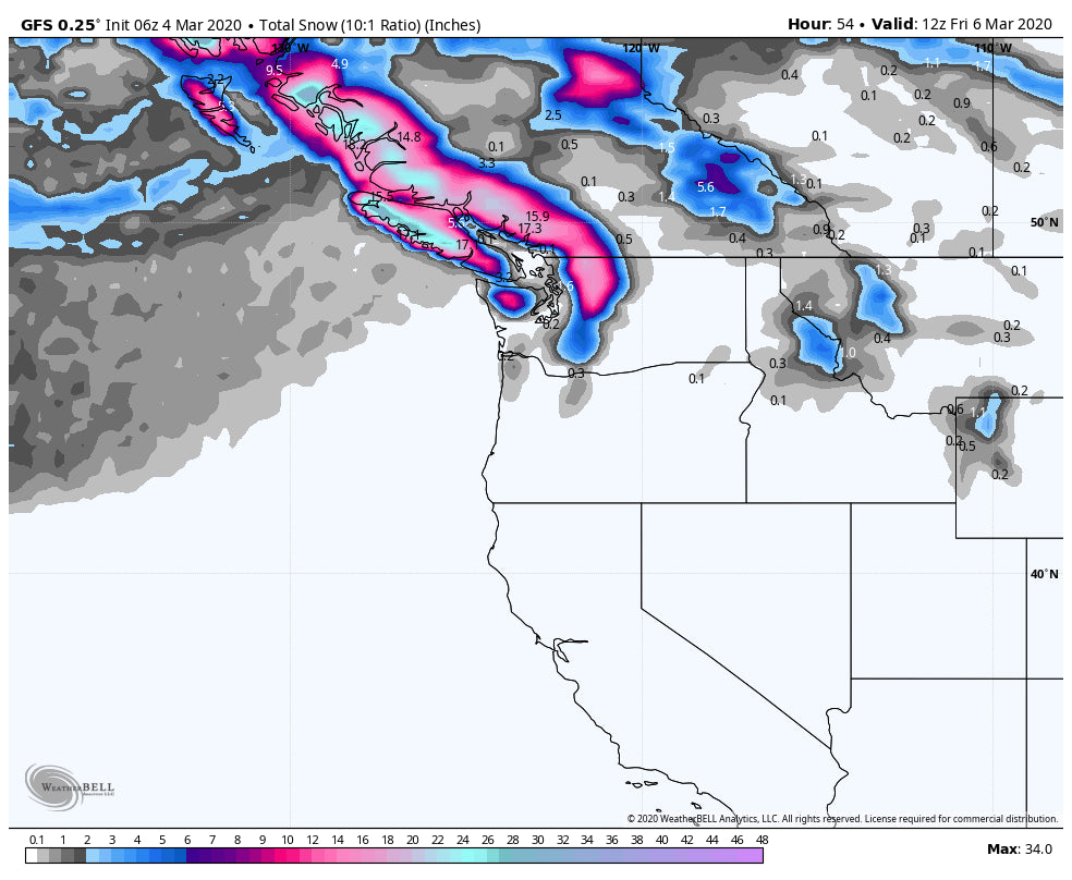
The next system will move ashore Thursday morning in BC (Light snow likely) and produce 6-10 inches for the upper summits of Whistler, Mount Baker, and perhaps Stevens Pass. The bulk of Precip at Whistler should occur Thursday late AM to late Evening (Storm ski last chairs and grab 1st chair Friday). For the Cascade range timing is primarily overnight (Bonus). The GFS models bring decent amounts from Baker to the I-90 Corridor (Alpental, Stevens), however, the Euro keeps the most significant amounts north of Stevens. The 12KM NAM also shows the bulk of precipitation staying further north. Plan on being in position for the PNW for Friday morning from I-90 or north. Whistler would also be a good chase for Thursday PM and AM Friday.
Below: Overview of the Pacific Northwest through late Friday showing the highest amounts in western portions from Whistler south to perhaps I-90 (Wildcard). It looks like Vancouver Island could get hammered (Mount Washington).

The system in the Northwest drops south into the Sierra by Saturday and should land some storm skiing for many resorts favoring the north. The models are showing mixed reviews, with the GFS at 10 inches and the Euro in the 4-7 inch range. The Canadian has even less. Confidence is high for storm skiing on Saturday in the north/central ranges of the Sierra but amounts are still unclear (3-10 inches).
Below: Total snowfall per the GFS solution for the Sierra by late Saturday. The central or northern sections of the Lake are favored versus the southern Sierra near Mammoth. This is a pretty optimistic model with the EURO Showing less (4-8).

EXTENDED:
The Rockies grab weakening leftovers late Saturday into Sunday. The bulk of moisture for the Rockies is likely to favor northern portions toward the Tetons or even Big Sky but amounts appear moderate at best. Utah and Colorado will be wildcards for Sunday morning but amounts are likely to be sub chase criteria (3-5).
The long-range operational models are hinting at an increase of moisture for the Rockies beginning Monday of next week. The GFS is bullish for some moderate or heavy amounts for the Wasatch, while the Euro less. The Ensembles which are relied on more heavily long term are not buying off on that solution just yet. For now, it's possible that several waves of light to moderate energy begin to impact the West next week but it's going to have to wait for some new model runs for me to sign off on it. The operational and Ensemble runs are in full disagreement. At least there are hints of some decent amounts in the Rockies.
Enjoy the powder everyone! Remember to support us by joining Powder Concierge for custom chase forecasts.
Powderchaser Steve


