SUMMARY
Its Super Bowl Sunday! In looking at multiple models this morning there are many locations to chase powder this Monday/Tuesday. Very warm and windy conditions over much of the Rocky Mountain Region Sunday will transition to sharply colder temps and snow for Monday/Tuesday. You can chase from Utah, Montana, Wyoming to Colorado and score 2 powder days. Midweek will bring storm #2 into the Rockies by Wednesday. Northern areas in the extended might be your best chase.
Rockies Forecast:
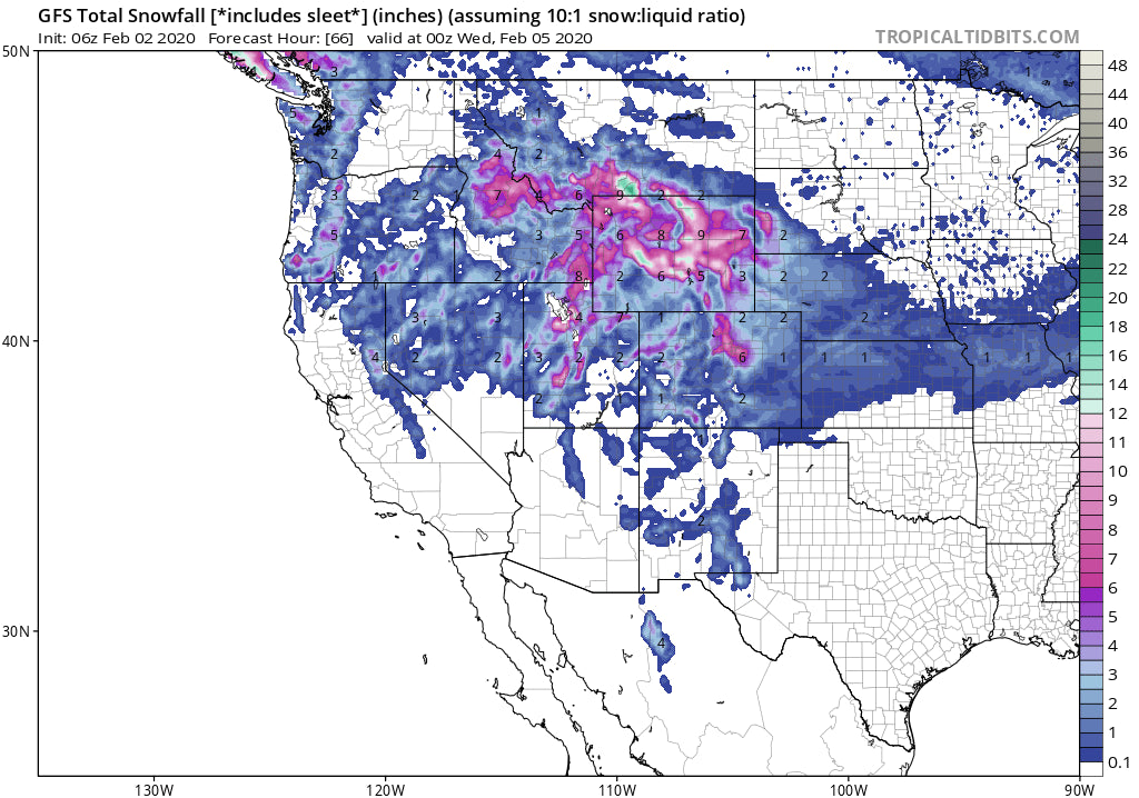
Very cold air will kick off snow from north to south through Sunday/Monday in Montana, Wyoming, Utah and eventually Colorado. Unlike other storms this winter most everyone in the northern Rockies will reap decent rewards by Monday or Tuesday. Snow will be falling by Sunday late AM in Montana and eventually reach the Tetons during the Super Bowl kick off before heading into Utah during the evening. Models are in good agreement with 8-12 inches for the Tetons by Monday morning and 5-10 inches for southern Montana including Bid Sky and Bridger. Red Lodge Mountain further east in Montana is likely to score higher amounts. Its great to be talking about Montana again! More snow will fall midweek.
The models diverge just a bit in the Wasatch with heavy snow falling late Sunday evening (Peaking just after midnight) into Monday. Heavy Valley snow is likely for the Monday morning commute perhaps 4-7 on the benches and lower elevations of Salt Lake by mid morning. Models are shifting the heaviest mountain snow into the northern Wasatch (I-80 north) with lighter amounts along I-80. Park City is likely to see 4-8 inches while Powder Mountain might grab 7-12. Snowbasin is a wildcard for heavy snow. The Canyons side of PCMR is favored with the NW wind direction. Deer Valley will see less. The Cottonwoods are likely to be in the 7-14 inch range by midday Monday. Orographics and NW winds behind the front will keep snow showers falling south of Salt Lake Monday night (Lake Effect). The Cottonwoods might grab another 3-6 inches during that period into Tuesday. There is more disagreement on the positioning of the deepest snow for Utah on the models. Its possible the Valley picks up more snow than the higher summits. The models show a chance for higher totals north of the Salt Lake Valley towards Powder or Snowbasin.
Below: University of Utah averages of all models showing a fair amount of discrepancy on totals for Alta in the 6-16 inch range. It's likely the 8-16 inch range will be met eventually by late Monday or early Tuesday (4-8 overnight Sunday). There is large discrepancy on the models, some showing the most snow further north of Salt Lake, much less in Summit County and the Cottonwoods. The HRR is not bullish but the NAM is bullish for the Cottonwoods.

Below: University of Utah averages of all models showing 6-10 inches for Powder Mountain by early Monday.

Colorado scores powder mid morning Monday to Tuesday. Models are in good agreement for the heaviest snow to fall along the Continental Divide north of I-70 (Berthoud Pass, Loveland, Winter Park, Eldora, RNP). These are areas are likely to see 7-11 inches by Tuesday morning (Last chair Monday may also deliver). Further West into Summit County expect 4-9 inches. A-Basin and Keystone may report higher amounts. The I-70 corridor west of Summit should be in the 3-7 inch range. The San Juans including Silverton and Telluride may score earlier on Monday in the 4-7 inch range. Wolf Creek will eek out 3-6 for Monday and higher amounts on the East side of the pass.
The Chase: Southern Montana, Tetons, Wasatch, Colorado (E. areas or SW Wildcard). Midweek storm on the extended pushes me further north initially (MT, WY) followed by Colorado on Friday (Wildcard).
EXTENDED
The extended brings another similar round of snowfall, perhaps deeper to the northern Rockies by Wednesday. The models are in synch for another moderate to perhaps heavy snowfall for Montana (This one will impact northern and southern zones) Wednesday filtering into Wyoming, Utah and Colorado for Thursday and Friday. The models diverge significantly on Colorado with the EURO showing 12 inches or more for many mountain locations and the GFS pushing only moderate moisture into the northern sections of the State for Thursday/Friday. Usually the GFS is overdone and the Euro the pessimist.
Below: Pessimistic GFS showing moderate snow for northern Colorado by Friday morning (24 hour total).

Below: The optimistic EURO showing heavy snow for most of N/Central Colorado ending Friday (24 hour total)

Bottom line: High confidence on 12 plus inches for Montana, Wyoming (Utah wildcard) Wednesday/Thursday. Moderate confidence on 12 inches or more for Colorado. If the EURO proves correct, Thursday and Friday will be deep powder days for most of Colorado.
For those of you looking for the fastest way to clean your car off from deep snow here's a discount code for the trusted snoshark that we personally use.
Enjoy the Powder everyone!
Powderchaser Steve


