
High-Level Summary
The warm stretch holds through Friday, then the pattern flips this weekend with more moisture and stronger winds pushing in from the Pacific. The Pacific Northwest gets the first meaningful snowfall, with the best totals focused on the northern higher Cascade resorts. Expect dense, heavier snow at the start, then a gradual improvement in quality as colder air lowers snow levels late Sunday into Monday. Amounts will be light aside from perhaps 5-9 at the upper elevations of Whistler
Early next week, the signal shifts south and inland. The Sierra looks lined up for a more powder-friendly refresh Monday night into Wednesday as temperatures drop and snow ratios climb.
Utah follows with its best window Tuesday night into Wednesday, though totals carry more spread there. Confidence is highest in the timing of the weekend change and the overall cooling trend, while the placement of the heaviest bands and how long the midweek snow hangs on remains the main variable.
Higher totals will stack up beyond mid next week in the extended
Resort Snowfall Totals (Feb 7-11)
-
Grand Targhee: 4-8inches
- Mt Baker: 4-7 inches
* Crystal: 5-10 inches
-
Mt Bachelor: 4-8 inches
-
Kirkwood: 6-12 inches
-
Mammoth: 7-13 inches
-
Solitude: 7-13 inches
-
Snowbird: 7-11 inches
-
Brundage: 8-11 inches
-
Brighton: 7-10 inches
-
Alta: 7-11 inches
-
Timberline: 8-10 inches (Upper elevations)
Storm Timing and Discussion

Farther north in the Washington Cascades, totals depend more on band placement and timing of the colder air. The GFS leans wetter in spots, while the ECMWF and the ICON come in lighter, so the spread stays meaningful even with decent agreement on the general setup. Crystal Mountain still looks set for a solid refresh at 7-11 inches Saturday through Monday, with the cleanest window Sunday night into Monday when snow levels are lowest, and wind impacts are less consistent. The AIFS generally splits the difference, and the GDPS keeps some upside alive if the better forcing hangs on a bit longer than expected.
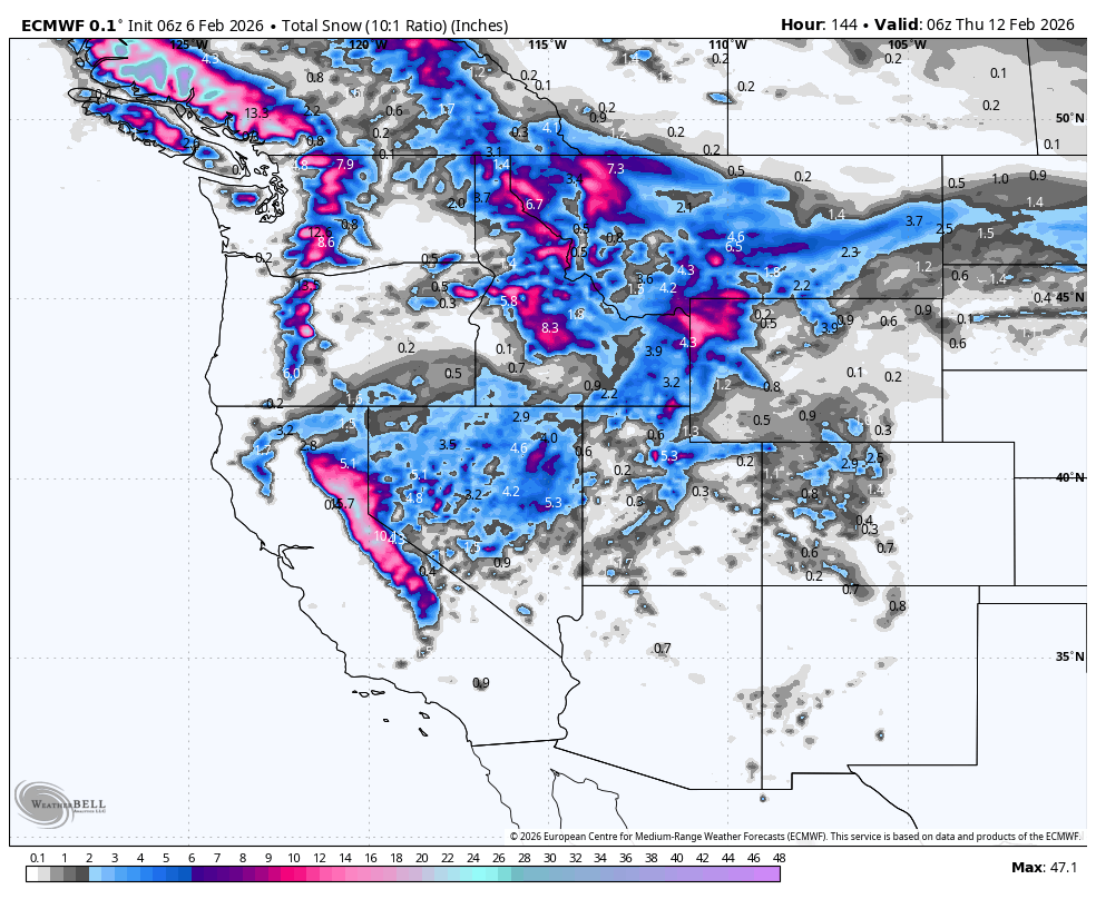
Below: Sierra snow through Wednesday night 2-12

By Monday night, attention shifts to California and the interior West, and snow quality improves. All models support a Sierra event Monday night into Wednesday, with snow levels dropping into the 4000-5000 foot range and ratios mostly 12-17 for moderate to fluffy snow. Mammoth leads that push at 7-13 inches, with Kirkwood close behind at 6-12 inches, and winds are more manageable than the weekend Cascades. Utah’s midweek storm builds Monday through Wednesday, peaking Tuesday night into Wednesday. Alta, Snowbird, Brighton, and Solitude sit in the 7-11 inch range, and the ICON and the GDPS trend higher than the ECMWF and the AIFS, which keeps the ceiling higher but the range wider.
Daily Chase Recommendations
Each day’s snowfall range combines the previous night (4 pm–8 am) and that day (8 am–4 pm).
-
Sunday (02/08): Chase the summits of Baker (3-5) or higher totals mid or upper elevations of Whistler.
-
Monday (02/09): Chase Brundage, Whitefish, or the panhandle of Idaho for 7-11 inches of heavy snow trending drier as temperatures fall, with Timberline still delivering 7-11 inches and deeper storm totals overall despite continued strong ridge winds.
-
Tuesday (02/10): Chase Mammoth for 5-9 inches of moderate to fluffy snow with lighter winds and a cooling trend, with Kirkwood close behind at 3-6 inches of similar quality. Some Sierra resorts are likley to see double-digit storm totals!
-
Wednesday (02/11): Chase Solitude for 5-10 inches of moderate snow with gusts near 40 mph, with Brighton as the alternate at 6-11 inches, where gusts near 50 mph may push the best skiing into sheltered aspects.
Extended Outlook

The pattern stays more active beyond midweek, with a continued signal for cooler temperatures along the West and recurring chances for precipitation across the coastal ranges and interior mountains. Late-week details carry lower confidence, so the next best target region can shift with shortwave timing and snow-level swings. The broader setup supports more mountain snow opportunities, and the best quality will line up with colder phases and lighter wind.
Below: The period from late next week into the following week (2/14 to 2/18) looks very active in the West. This map shows 24-hour incremental snow totals in the west through the period. Let's hope these models hold up, as we are still outside the window of confidence. The Sierra may end with totals in the 2-3 foot range or higher by February 18th.

HELP US OUT- Please support your love of powder and our free forecasts with a donation here, or join our concierge program. We have merch on the website.
We appreciate the support.

Forecaster: Clay Marlot


