
Quick Update- 4:30 PM MST- Sunday
Heavy snow fell all day from about 4AM to 4PM favoring the Teton Range in Wyoming. At 4AM there was only 2-3 inches of new overnight snow at Grand Targhee and JHMR. The snow reports showed 4-5 overnight at 6-AM. The Firehose turned on from 6AM to 4PM with 3-4 inches per hour at the summits to close the day out with 21 inches of fresh powder in the Tetons
My clue at 5-AM was the radar and snow telemetry that showed an excess of 1 inch per hour at the summits. The chase took me to JHMR where I missed 1st tram but narrowly caught the 2nd driving from Idaho Falls this morning (Staging area). It was a close call between Targhee and JHMR. JHMR can often score more snow with W or SW wind direction. Targhee does better with NW winds. It was a gamble that proved correct. Models show another 2-4 inches possible for the Tetons Sunday night as temps cool and most of the moisture weans after 6PM. Its possible some higher amounts occur especially at the summits.
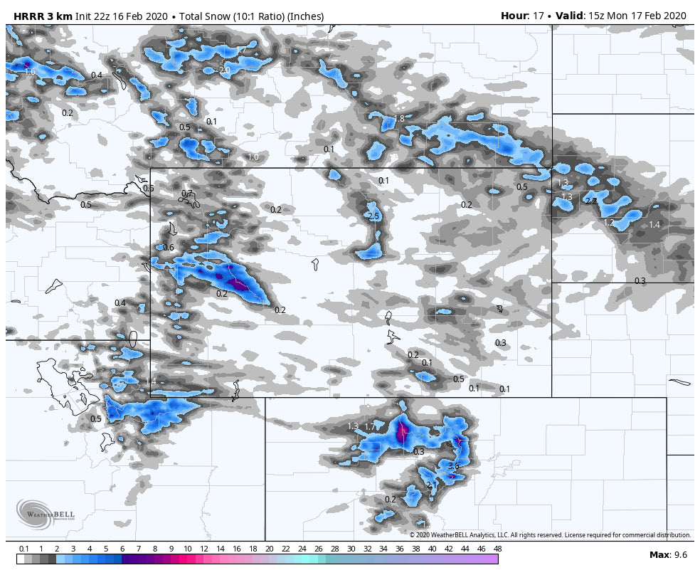
In Colorado a band of snow spread 3-6 inches amidst most ski resorts along I-70 and north early Sunday. The notable exception was Winter Park who's snow camera is near 12 inches seen below. Can someone verify this?

The Wasatch kicked in shortly after the Tetons with warmer temperatures and 8 inches of snow during Sunday (Upside down as temps warmed during the day). One exception might be the Northern Wasatch who stayed cooler during the day with Powder Mountain showing lower temps and 8 inches of snow on Sunday. Park City had 8 inches on the Canyons Side. Its likely the Cottonwoods reap another 5-9 inches Sunday night into Monday with an outside chance of higher amounts above 8000 feet favoring LLC.
In looking for the best options to chase, northern Colorado will likely report the highest totals as of Monday morning. Ride north of I-70 towards Rabbit Ears Pass, Steamboat, and perhaps the northern sections of Rocky Mountain National Park. Models show 6-12 inches for this region and 3-6 along the I-70 corridor. I have high confidence in this occurrence. The only thing pushing me back slightly is that the radar shows decent precipitation further south in the Rifle area, just edging into Aspen as of 4 PM Sunday. This may also move east over the I-70 in the next few hours increasing amounts in some areas (2-5 is my forecast). Snow just increased in the Vail Valley as well.
The other winner to close out the holiday weekend will be the central Cascades of Washington. Cold air and westerly flow will bring 12-15 inches to Alpental, Stevens, Snoqualmie Pass from Sunday night to early Monday. Mountains to the south or north will see lower amounts.
The pattern shifts to high pressure next week with the chance of another storm midweek teasing NM. Beyond that, low pressure returns late next weekend with a chance of snow returning to the Cascades and eventually the Rockies early the following week. The Sierra may also get into the action finally but confidence remains low on amounts.
Below: Ensembles for February 23rd (Sunday) showing relatively deep trough entering the PNW by Sunday. There may also be a teaser for the Sierra mid next week?

Enjoy the Powder everyone! \"See you on first chair- but that did not happen today\"
Powderchaser Steve


