SUMMARY
High Pressure is taking hold this week in the West with the next low pressure pattern setting up over the BC Coast and Cascades by Saturday night. Decent snowfall is likely for the Cascades late this weekend and early next week with reasonably low snow levels (3000) that eventually plummet to 200 Feet by Monday morning. That system will favor many areas of Idaho (North and central Panhandle), west central Montana, and eventually the Tetons and perhaps Colorado in the extended forecast. Another storm might impact Colorado favoring the southern or central mountains on Saturday night.
FORECAST
The past 4 days brought a chase that NET me 46 inches of powder by starting in Washington State (Stevens Pass- 17 inches overnight), hitting the Tetons (21 inches at Jackson), and finishing in Utah (10 inches overnight at Snowbird- 18 inch storm total). What a score! 3 states in 4 days and all very high quality.
The forecast was on track with early predictions of 11-18 inches for the Tetons Sunday (Over performed), 12 for Steamboat (Reported 10), and 11-18 inches for the Wasatch (18 at Snowbird). The only dud in the forecast was much less snow at Stevens Monday morning where only 5 inches had fallen. The southern Cascades also came up short with generally teasers of 3-5 inches each day towards Crystal. There were no single deep dumps other than the 17, I scored at Stevens Pass last week and some of the northern Oregon resorts that nabbed double digits last weekend. Bachelor saw 9 inches where Timberline further North nabbed 26 inches. The resorts along Interstate 90 (Alpental and Snoqualmie) also did well.
The upcoming week takes a break in the action with no significant storms in the models for the West. The Denver Front Range should see some light snow with North/NE winds impacting primarily the metro areas Tuesday night into Wednesday. Some very light snow may graze Eldora or the Winter Park with a light freshening at best for Wednesday morning.
There is a storm that sneaks up from the South on Saturday night that could bring some decent snow totals to the San Juan Range of Colorado by Sunday morning. Moderate snow is also possible for the central mountains of Colorado Sunday morning.
Below:A storm edges into the southern and central mountains of Colorado by Sunday morning. Telluride is in the deeper reds (6.9 is the airport) on the left side of the map time stamped 5AM Sunday. The I-70 corridor will see moderate snow with higher amounts to the south.

The Extended brings a return of unsettled weather to the West favoring the Pacific Northwest and Rockies. The East might also get into the action late this month into early March.
EXTENDED:
Low pressure approaches Vancouver Island late Saturday. Coastal BC and the Pacific Northwest should all see snowfall beginning late Saturday night or early Sunday morning (North to South). Snow levels appear reasonable (Not cold, nor too warm) for a decent event Sunday/Monday for many areas of the Cascades (Washington and Oregon). NW winds might favor central or southern areas. Much colder temps move into the PNW Sunday night and Monday crashing snow levels to 500 feet above sea level. Significant snow is possible under convergence zones over Washington State along I-90 or north to Stevens for Monday morning. Confidence is still in the moderate category due to this storm being 5-6 days out.
Below: Low pressure trough approaching the PNW by Sunday morning.

That system moves into the Idaho Panhandle (North and central areas are favored) late Sunday to Monday. The track might favor the Tetons, northern Wasatch and Colorado by Monday and Tuesday next week. The model runs are showing some enhanced precipitation totals for the northern San Juan Range (Telluride) and even the southern San Juans (Lower confidence).
Below: Low pressure moves over the Rockies by Monday next week.

While this far out, confidence is high for the PNW this weekend and moderate odds of a dump for the northern Rockies by Monday. The track beyond Monday needs to be watched for both Utah and Colorado. Some models edge the highest amounts north of Utah and extend into west or southern Colorado by Tuesday. That is something that will be watched closely in the next several days.
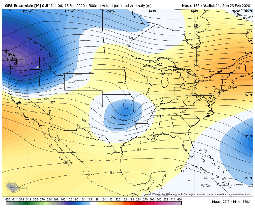
In looking at the longer range models, its likely that low pressure focuses on the Midwest and East Coast with a return of snow towards the end of February and early March timeframe.
Below: End of February might bring higher odds of low pressure for the Northeast or Midwest that could extend into early March.

Enjoy the Powder stashes or break in the action this week before the next storms roll in next week. Please support Powderchasers by joining the Concierge program (Custom forecasting). Don't forget to check out our sponsors for items that we endorse for your chases.
Powderchaser Steve


