
SUMMARY:
Tricky temperatures, high winds will make chases risky this weekend in the Sierra. The Rockies score deep snow above 7,000 feet, especially the northern Tetons, Yellowstone with some wildcard bets for the Wasatch and isolated areas of Colorado on Sunday. The extended looks decent for the PNW and the northern Rockies.
Sierra chases
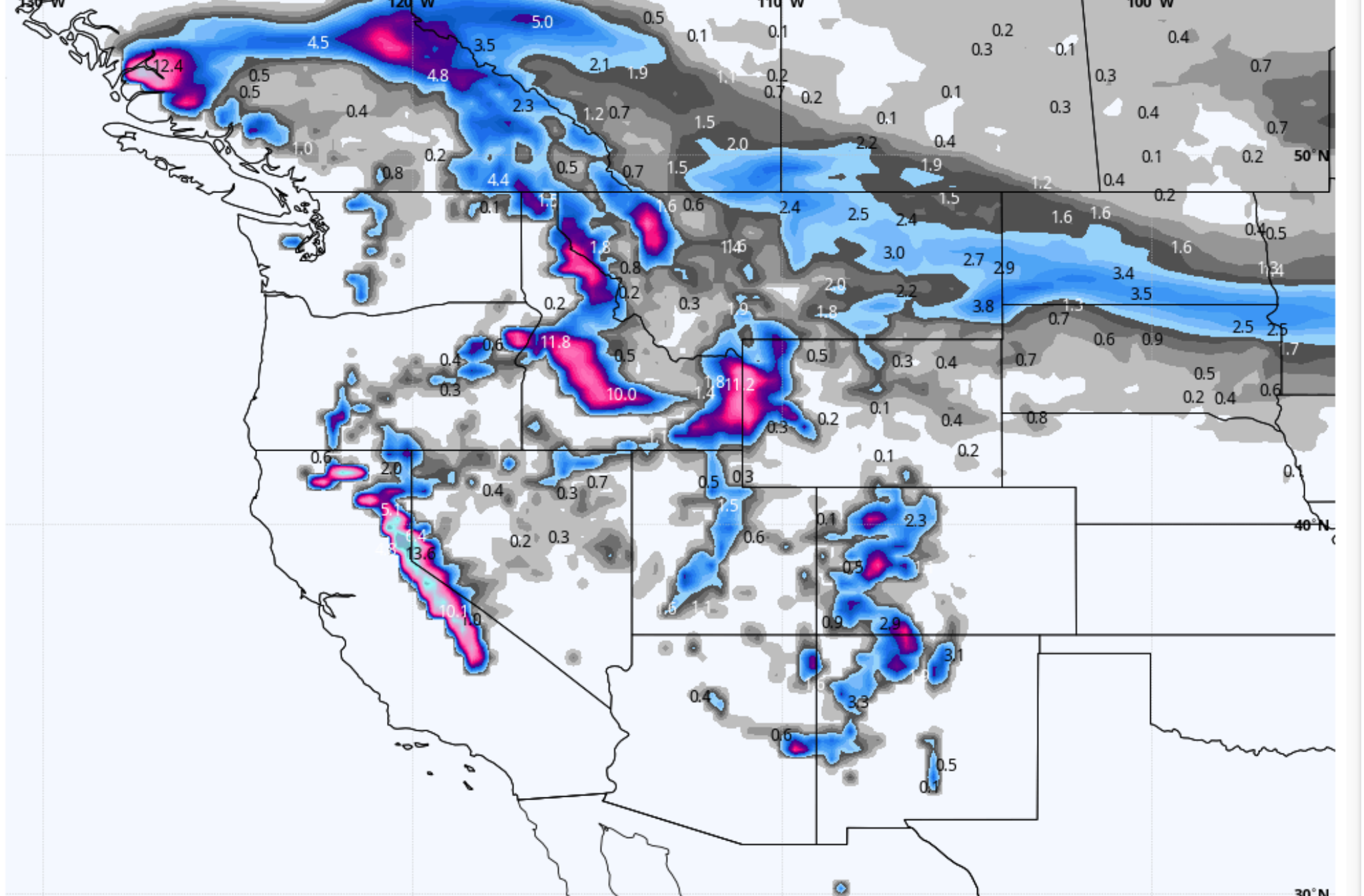
It's snowing in the Sierra this morning above 8,000 feet. Snow telemetry shows 8 inches at the Squaw automated stake fell since 9 PM Friday night. 0 snow appears to have fallen at 6500 feet. It may be raining at the bases of many ski areas this morning. Colder air will arrive Saturday night driving levels lower and some snow likely to all base areas. Stick to the higher elevation resorts. Mammoth will likely see all snow during the next 24-48 hours. Winds will be very strong Saturday so all chases have some risks with upper terrain likely on wind hold. Perhaps aim for Sunday or Monday (New terrain openings from what may be closed on Saturday). Storm totals will be in the 2-3 foot range at upper elevations through Sunday. The northern Sierra may be favored slightly over the south.
Rockies chases
Decent leftovers under SW flow will set up over Idaho late Saturday/Sunday favoring the northern Wood River Basin (Sun Valley) with the highest amounts near Stanley. I also think that most central Idaho resorts can do with this pattern. Most of the heavier snow totals will be confined to the mid or upper mountain.
That system drags into the Tetons late Saturday night into Sunday. The GFS remains bullish for the Tetons for 4-8 inches overnight Saturday and another 4-8 inches for Sunday. Totals should range from 8-16 inches by the last chair on Sunday. There may be some higher amounts at the summits. The Euro shows less snow for the ski areas (6-11) and higher amounts confined to the northern Tetons and Yellowstone. SW winds Saturday night might favor JHMR over Targhee initially. Winds shift to the West Sunday that could be decent for both resorts. NW flow dominates late Sunday as moisture begins to decrease and favors Targhee.
For Utah and Colorado, there are wildcard picks. Generally, the models are not overly impressive. My forecast is going with 4-8 inches for resorts in Utah. The GFS downtrended further for the Wasatch while the 3KM NAM (Overdone often) still shows 10-20 inches for the Cottonwoods. The ensembles still show a lack of confidence in amounts. The northern Wasatch (Snowbasin and north) may benefit initially on Sunday morning with SW wind direction. Winds switch to the West, NW late AM or early PM Sunday that will increase intensities for the Cottonwoods. Cold air is lacking initially Sunday morning with the highest moisture (Not overly impressive intensities). Colder air mid-morning or early PM Sunday with W/NW winds should increase amounts into Sunday evening. The Bottom Line: General forecast of 4-8 inches for most of the Wasatch resorts with an outlier chance of 8-12 for the Cottonwoods. Ride Sunday (Snowing) and look for some snow to continue into the evening making Monday a solid wildcard.
In Colorado SW winds initially on Sunday (Snowing) will favor the southern San Juan range. Early morning snow reports are likely to report light amounts initially for areas south of I-70. Snow picks up during the day Sunday with the winds shifting to the West/NW in the afternoon. The models have been consistent for the highest amounts falling in the central mountains near Crested Butte, perhaps Monarch, extending north into the Aspen Valley (Wildcard). 6-12 inches are possible in these areas. Further north or east and along I-70 generally 4-8 inches are likely (Including Telluride). Western areas of I-70 towards Beaver Creek (West winds are best here) and Vail (NW winds) may end up with higher amounts. Steamboat is a good wildcard also.
Whew! Good confidence in snow for many areas. Models are not overly consistent in some areas (Utah especially) but higher confidence for the northern Tetons (let's hope the ski areas both score). Colorado is a sure bet for some powder especially Mid-morning Sunday to Monday with someone scoring a foot of pow in the central mountains.
Below: Total snowfall for Colorado through Monday.

EXTENDED POW:
The trend in the extended forecast is for moisture to start impacting the Pacific Northwest mid to late week. These systems will be colder and are likely to drag over the northern Rockies in the latter portion of next week. Some decent amounts of better quality pow are possible. You might want to start planning for some chases late in the week for the northern Rockies. The PNW will finally start to base build.
Powderchaser Steve


