
This winter is teaching the same blunt lesson across the country: precipitation only becomes ski season if the atmosphere is cold enough, long enough, at the elevations that matter. In much of the West, storms have shown up with plenty of moisture but a frustratingly high rain-snow line. Farther inland and north, the same storm conveyor has been just cold enough to translate into real snow-water and a developing base. In the East, cold has been widespread, so snow cover is extensive.'
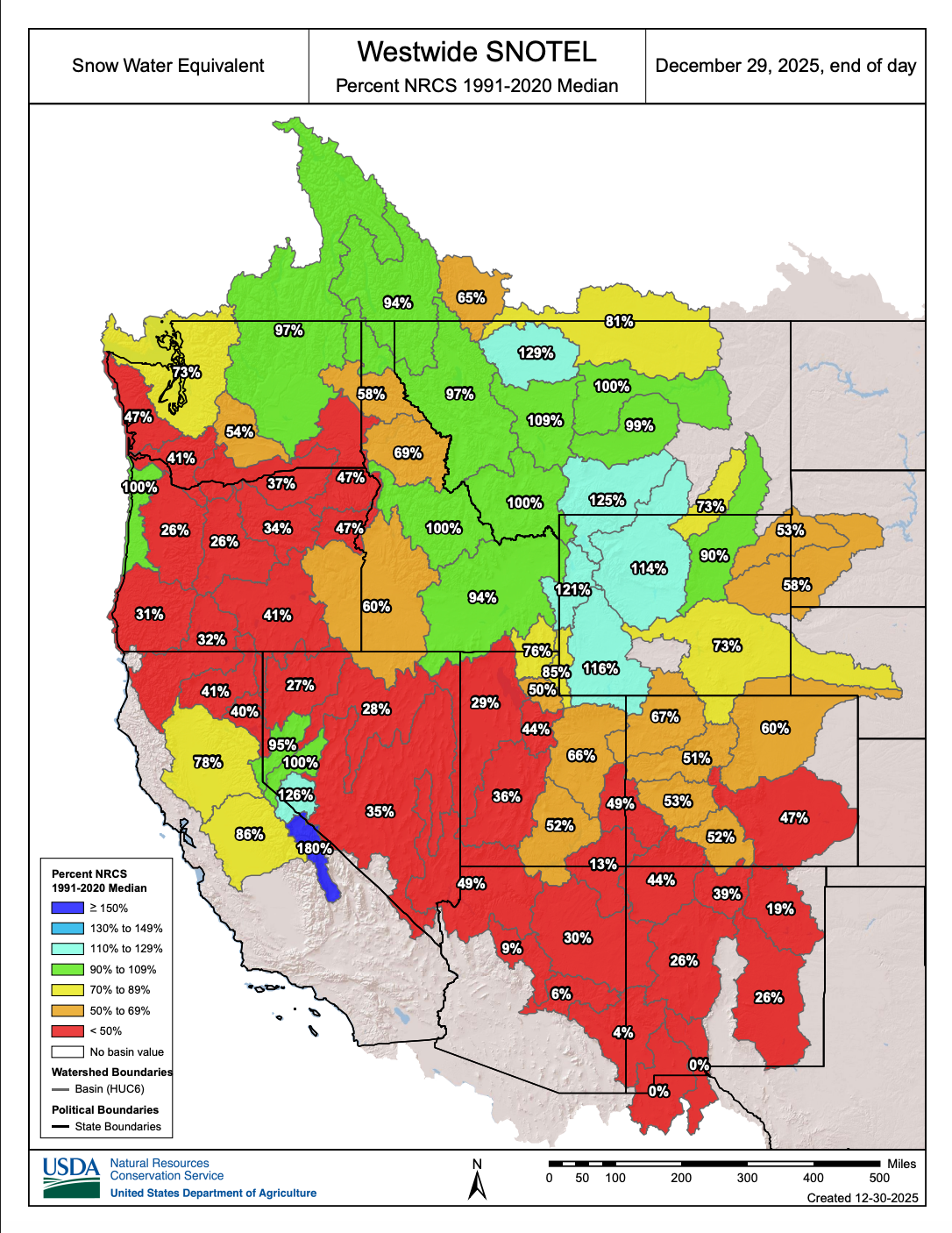
Below: Snow water equivalent (melted snow in the current snowpack). Some of the higher numbers on this chart reflect higher elevations in the northern Rockies with lower averages at the bases. Not surprisingly, most basins are well below normal. Keep reading for the water totals.
 Below: Water averages in the west are near or above average in many areas.

The background signal is La Niña. Niño 3.4 is running roughly -0.7°C, with the most recent ONI (Sep–Nov 2025) near -0.6°C, and La Niña is favored to hold into early 2026 before trending toward neutral later in winter. That nudges the jet stream and storm track toward the northern tier often enough to matter, but the lived experience for skiers so far has been dominated by a second ingredient: repeated warm profiles over the West that keep lifting the freezing level during otherwise productive storms. Early December’s western snow cover was exceptionally low for the time of year, a classic snow-drought setup where it can be wet and still not accumulate efficiently.
Below is a region-by-region breakdown of what we've seen so far this season.
Pacific Northwest: wet storms, shallow snowpack

In the core Cascade watersheds that mirror Oregon resort country, SWE is shockingly low: the Willamette basin sits near 26% of median, the Hood/Sandy/Lower Deschutes zone near 29%, and the Upper Deschutes/Crooked near 27%. Precipitation is not the main problem; in the Hood/Sandy/Lower Deschutes grouping it’s about 120% of median. That mismatch is what warm storms look like on a snow chart: the water arrives, but too much of it falls as rain in the elevation band that normally builds early-season coverage, and what does fall as snow settles hard.

Washington is more nuanced, and the nuance matters if you’re choosing where to drive. The north Cascades are hanging on to winter, with North Puget Sound around 104% of median SWE. Slide south and conditions fall off fast: South Puget Sound is near 47%, Central Puget Sound near 53%, and the Upper Yakima, relevant to the I-90 crest and south-central Washington terrain, is also around 47%. Yet precipitation in those same basins commonly runs in the 140–150% of median range. This is not a dry pattern. It’s a warm pattern, where storms deliver a lot of liquid and the rain-snow line does the damage.
The meteorology is straightforward in skier terms. A maritime storm can be a powder producer when the thermal profile is cold. When the larger-scale pattern leans warm over the West, those same storms bring mild Pacific air inland and the freezing level climbs into mid-mountain elevations. Resorts can still score on the upper third of their vertical, but continuity suffers because each warm phase erodes the base you need for tree skiing and natural terrain to become reliable.
California: late-December saved the snow, not fully the water content

California flipped from anxious to optimistic in a matter of days, but the snowpack is still playing catch-up. Statewide Sierra snowpack is about 71% of average for the date. At the same point last season it was closer to 115% of average, so this is not a deep-start year even after the Christmas storms. The internal distribution is uneven: the northern Sierra is around 50% of normal to date while the central Sierra sits in the upper 70s and the southern Sierra in the mid 90s.
That pattern matches what skiers have felt on the ground. Tahoe improved sharply, and the numbers in Tahoe-adjacent basins are near normal: Lake Tahoe sits around 91% of median SWE and Truckee around 96%. South and east along the crest, the Walker basin is even healthier near 127%, which helps explain why higher-elevation, southern-leaning zones have looked more winter-like.
The key caveat is that big snowfall totals do not always mean big water content when the snow arrives warm and dense, or arrives late and has little time to build layers. A late-December manual measurement at Phillips Station found about two feet of snow but only about half the typical water content for the location and time. That is the signature of a season that has been playing defense against warmth: fewer cold, low-snow-level events, more consolidation, and more vulnerability to the next warm intrusion.
Northern Rockies: the most winter-like zone in the country

In Montana, major headwater basins tied closely to resort terrain are at or above median: Flathead around 121% of median SWE, Gallatin about 113%, and the Upper Yellowstone around 125%. Wyoming’s western mountains are similarly strong: the Snake basin is about 123% of median SWE, Yellowstone headwaters roughly 143%, and Wind River around 124%.

Idaho shows a north-to-southeast improvement. The northern panhandle is below normal around 76%, but central and eastern Idaho look solid: Salmon near 100%, Big Wood around 111%, and the Snake above Palisades near 123%.
The “why” is largely thermodynamic. These interior ranges are cold enough, often enough, that storms do not need to be perfect to build a base. Pacific moisture arrives, it gets forced upward by terrain, and the temperature profile is more likely to keep precipitation as snow through the elevation band where accumulation matters. In a year when coastal zones are frequently wrestling with a high rain line, the northern Rockies have been cold enough to simply cash the checks.
Central and Southern Rockies: the season is behind where it usually is by New Year’s

In Utah, two key Wasatch-front basins are running near half of median SWE: Weber–Ogden around 49% and Provo–Utah Lake–Jordan around 47%. The Bear River is better near 82%, and the northeastern Uintas sit around 78%, which reinforces the theme that colder, higher, more interior terrain is doing better than lower and more marginal zones.

Colorado is broadly below normal, with only pockets approaching “okay.” Yampa and White are around 67% of median, South Platte about 62%, Upper Colorado near 51%, Gunnison about 53%, and Arkansas around 47%. Southern Colorado is especially telling: the San Juan-adjacent group (San Miguel, Dolores, Animas, San Juan) is around 49% of median SWE even with precipitation around 116% of median. That is the warm-storm fingerprint again: moisture shows up, but it is not efficiently turning into retained snow-water in the high country.
New Mexico is the harsh end of the gradient. Upper Rio Grande in New Mexico sits around 30% of median SWE, and the Sangre de Cristo basins around 35%, a level that forces resorts to rely heavily on snowmaking and leaves natural terrain waiting for a pattern change.
The atmospheric explanation is a blend of track and temperature. La Niña winters often tilt storms north, but this December’s bigger issue has been the recurring warmth-leaning height pattern over the West and adjacent interior. That tends to keep the jet core either north of Utah and Colorado or progressive and less moisture-rich when it does dip in, and it also makes marginal storms behave more like rain events at mid elevations.
Please help us out if you read our free forecasts by considering some of our high-quality merchandise in our powderchaser store.
HELP US OUT- Please support your love of powder and our free forecasts with a donation here, or join our concierge program. We have merch on the website.
We appreciate the support.
Forecaster: Powderchaser Steve @powderchasersteve (Insta).


